All Activity
- Past hour
-

December 2025 regional war/obs/disco thread
SouthCoastMA replied to Torch Tiger's topic in New England
If you haven't noticed, that has already started and may peak well before Christmas. -
Gefs continue with normal temps with ridge draped across the southern tier being pushed sw.
.thumb.png.f89609abbea0f7e45ed3d38c0ae475d9.png)
-
You’re not the only one
-
Finally above freezing, just in time for any precip. Funny how precip chasing warm always works out. 37F
-
We closed twice last year for cold, but never had enough snow to close for that
-
We are talking about possible light snow here on Friday and possible heavier event on Sunday... Keep up
-
Yeah. I'm really confused what were talking about here lol
-
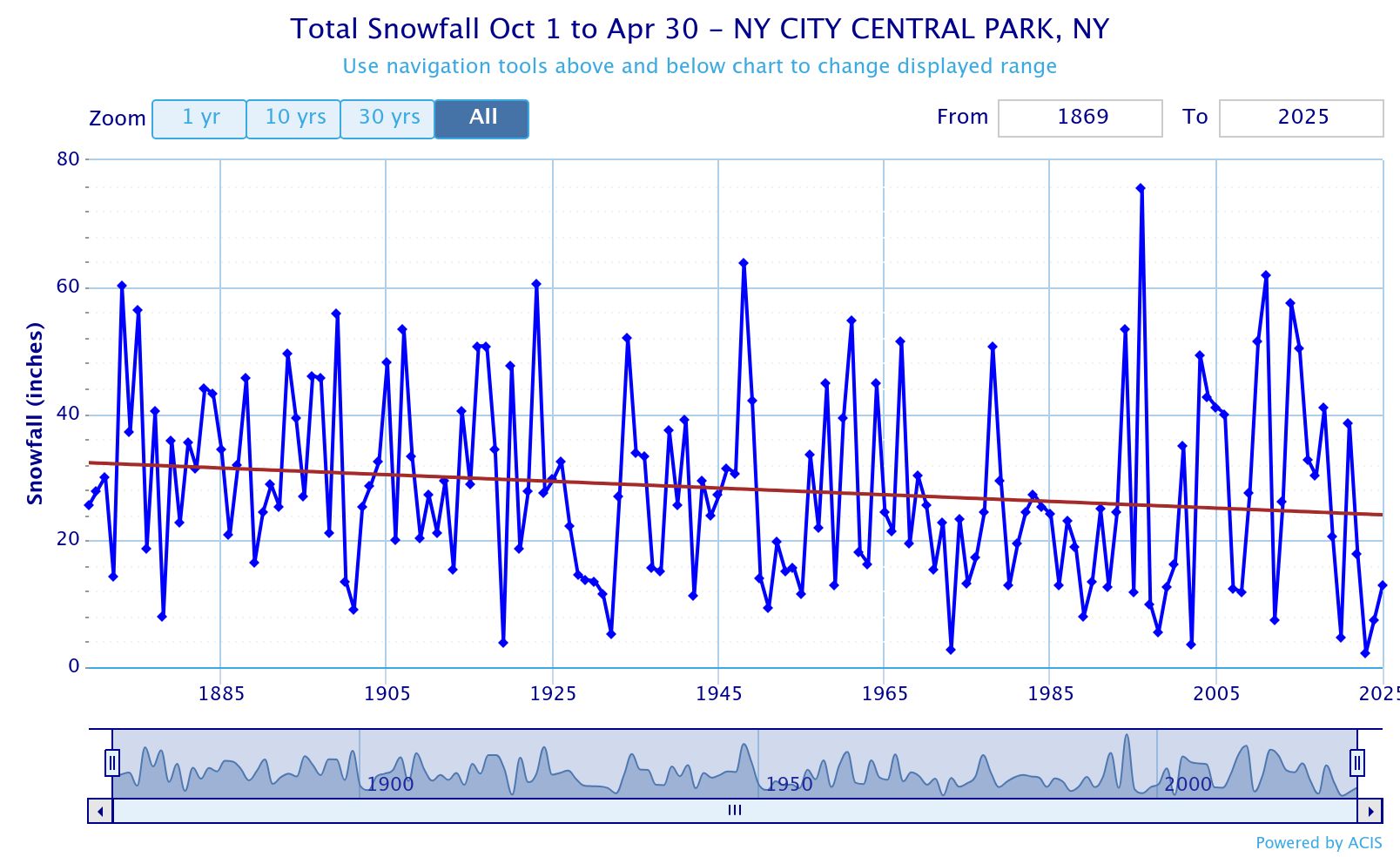
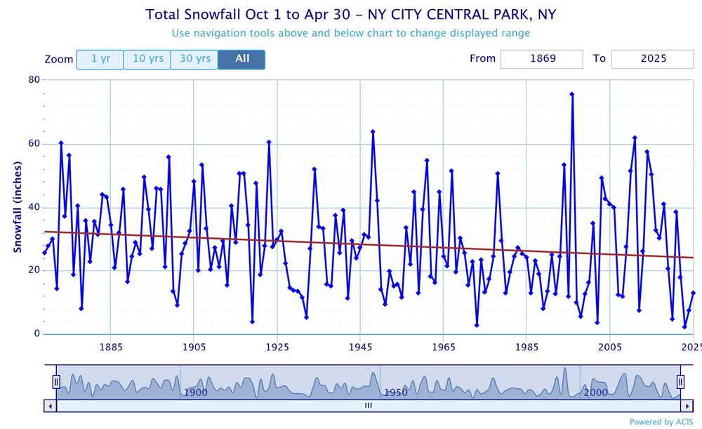
In a warming climate we can get larger snowstorms which is what happened during 2010 to 2018. The main caveat was that we needed the dominant storm track to be colder to our southeast in order to realize the higher snowfall potential. With the northwest and warmer shift to the storm tracks since 2018-2019, we have resumed the long term downward trend in the snowfall setting all-time 7 year record lows for snowfall.
-
What are we doing here? I mean i know, but I don’t. There are two different things and 4 scenarios with each thing and alternating jacks that switch places between both things.
-
I do not know if anyone knows... but the Beta version of Pivotal Weather now has the Euro 6z/18z for free.
-
I know Nam is out of its range but just looping to 84 makes you wonder how some one doesn't get a nice 2-4" storm
-

December 2025 regional war/obs/disco thread
weatherwiz replied to Torch Tiger's topic in New England
Sure does If you live in Bloomington, IL -

December 2025 Short/Medium Range Forecast Thread
Carvers Gap replied to John1122's topic in Tennessee Valley
Thanks for posting that. I could see that get expanded into W NC overnight. They almost meet the criteria. -
-
It's the NAM.but looks interesting at hr 84
-
3K was ugly here, 12z RAP was 2", That's what i see anyways, It's pretty borderline, I expect about 1-2" max of a mix, Looks like we don't sniff freezing at the surface anyways.
-
Blockbuster season out there:
-

-
It was RN/SN mix earlier this morning now its primarily snow. Not much accumulation with temps above freezing but the roads are slushy.
-
3k looks like 1”+ here. We both ride that ptype line though.
-
Don’t you think it’s more averages coming out of snowy 2000s and 2010s, and now less snowy 2020s? Cyclical + Warmer Background Temperatures? .
-
-
-
Some of the lousier runs try to spawn a norlun in the GOM. Exciting.
-
Records: Highs: EWR: 72 (1946) NYC: 70 (1946) LGA: 70 (1946) JFK: 59 (2015) Lows; EWR: 8 (1968) NYC: 3 (1876) LGA: 9 (1968) JFK: 9 (1968) Historical: 1699 - A severe ice storm hit Boston, MA, causing much damage to orchards. (The Weather Channel) 1904: 7.0 inches of snow occurred in in Washington, DC and 10.0 inches in Baltimore, MD. (Ref. Washington Weather Records - KDCA) 1919: Bend, Oregon: A new 24-hour snowfall record for the state is set when Bend records 28 inches. (Ref. WxDoctor) Cheyenne, WY reported the last of five straight days of snow. On this date, they set a daily record with 9.3 inches and 18.6 inches over the five days.Record low temperatures were set from the Plains to the West Coast including: Glasgow, MT: -32 °F, Waterloo, IA: -29 °F (broke previous record by 14 degrees), Havre, MT: -28 °F, Williston, ND: -27 °F, Bismarck, ND: -26 °F, Norfolk, NE: -26 °F, Duluth, MN: -23 °F, Scottsbluff, NE: -22 °F, Rochester, MN: -21 °F, Lander, WY: -21 °F: Tied, Great Falls, MT: -20 °F--- While Gainesville, FL set a record high with 83 °F. (Ref. Wilson - Additional Temperatures Listed On This Link) 1946 - The temperature at New York City soared to 70 degrees. (David Ludlum) 1946: High pressure along the southeast coast brought a south to southwesterly flow of unseasonably warm air to the east. Record high temperatures for the date included: Roanoke, VA: 73 °F, Newark, NJ: 72 °F, Harrisburg, PA: 71 °F, Baltimore, MD: 70 °F, Allentown, PA: 70 °F, New York (Central Park), NY: 70 °F, Lynchburg, VA: 69 °F-Tied, Atlantic City, NJ: 68 °F, Philadelphia, PA: 68 °F, Wilmington, DE: 67 °F, Hartford, CT: 67 °F. (Ref. Wilson - Additional Temperatures Listed On This Link) 1949 - The barometric pressure at Las Vegas, NV, reached a record low reading of 29.17 inches (987.8 millibars). (The Weather Channel) 1963: A winter storm moved across Oklahoma through the 11th. Freezing rain and sleet glazed highways, along with snow depths reaching two inches on top of the ice. 100 traffic accidents occurred at Oklahoma City alone during the evening rush hour the next day, and more than 14 injuries were reported due to falls on the ice. Ice accumulations on telephone lines knocked out service to parts of northwest Oklahoma. (Ref. Wilson Wx. History) 1967: During the overnight hours, a tornado struck Ft. Walton Beach, FL and Ocean City in Okaloosa County destroying 35 homes and nine businesses. One person was killed and 40 people injured. 33 businesses and 290 homes were damaged. An hour later, a tornado touched down briefly at Tyndall Air Force Base and again across the Bay in Parker and Callaway. One fatality occurred at Tyndall AFB as did most of the severe damage with 34 injuries. 39 homes at Tyndall were destroyed. A few hours later, a tornado destroyed four farmhouses and several barns in the rural area between Blountstown and Altha, FL. (Ref. Wilson Wx. History) 1971: A strong ridge across the Florida Straits brought unseasonably warm temperatures from the Great Lakes to the Southeast. Charleston, WV tied their record high for December with 80 °F. Other daily record highs for the date included: Orlando, FL: 85 °F, Montgomery, AL: 78 °F, Pensacola, FL: 78 °F, Huntington, WV: 76 °F, Bristol, TN: 76 °F, Nashville, TN: 74 °F, Beckley, WV: 73 °F, Knoxville, TN: 73 °F, Birmingham, AL: 72 °F-Tied, Columbus, OH: 72 °F, Elkins, WV: 72 °F, Lexington, KY: 72 °F, Paducah, KY: 72 °F, Louisville, KY: 71 °F, Oak Ridge, TN: 71 °F, Evansville, IN: 70 °F. (Ref. Wilson - Additional Temperatures Listed On This Link) 1972: A deep upper level trough extending from the Rockies to the West Coast continued to bring brutally record cold. Yosemite, CA reported their earliest sub-zero temperature on record with -1 °F. Las Vegas, NV recorded a high temperature of 32 °F. This was the coldest high temperature ever recorded in December. (Ref. Wilson - Many Additional Temperatures Listed On This Link) 1977: The eastern two-thirds of Iowa struggled with blizzards from the 8th ending on this date as 5 to 12 inches of snow fell. Locally heavier amounts fell over the northeast portion of the state. Bitterly cold temperatures of -10 degrees below zero combined with winds of 50 mph to produce wind chills of around -70 °F. Drifts piled up to 10 feet. The blizzard closed roads, stranded motorists and caused equipment to be brought in from western Iowa to help clear roads. The winds broke power lines shutting off heat and water for some residents. (Ref. Wilson Wx. History) 1987 - A cold front brought high winds to the eastern slopes of the Northern and Central Rockies. Winds gusted to 97 mph at Mines Peak CO. In Wyoming, up to a foot of snow blanketed the Teton Village Ski Resort, northwest of Jackson. Strong chinook winds in the Central High Plains Region, gusting to 61 mph at Scottsbluff NE, warmed temperatures to near 70 degrees. (Storm Data) (The National Weather Summary) 1988 - Squalls produced heavy snow in the Lower Great Lakes Region. Totals in northeastern Ohio ranged up to 14 inches at Harpersfield, and totals in western New York State ranged up to 14 inches at Sodus. In the snowbelt of Upper Michigan, the Ontonogon area reported two feet of snow in two days. (Storm Data) (The National Weather Summary) 1989 - Heavy snow fell across the northern and central mountains of Colorado, with 24 inches reported at Steamboat Springs. Six to twelve inches of snow fell in the Denver and Boulder area delaying plane flights and snarling traffic. Heavy snow also spread across the Central Plains into the Mississippi Valley. Winner SD received 11 inches of snow, and more than ten inches of snow was reported north of Sioux City IA. (The National Weather Summary) (Storm Data) 1989: Heavy snow fell across the northern and central mountains of Colorado, with 24 inches reported at Steamboat Springs. Six to twelve inches of snow fell in the Denver and Boulder area delaying plane flights and snarling traffic. Heavy snow also spread across the Central Plains into the Mississippi Valley. Winner, SD received 11 inches of snow, and more than ten inches of snow was reported north of Sioux City IA. (The National Weather Summary) (Storm Data) 1992 - A slow-moving Nor'easter storm batters the northeast U.S. coast killing 19 people. 1995: Intense lake effect snow squalls buried Buffalo, NY under 37.9 inches of snow in 24 hours, the city's greatest 24 hour snowfall and biggest snowstorm ever. Watertown, NY recorded 39 inches of snow in just 12 hours, and had 4 inches of snow an hour for 6 consecutive hours. (Ref. Wilson Wx. History) 1998: Santa Ana winds started on the 9th and ended on this day across southern California. Gusts reached 101 mph at Modjeska Canyon, 93 mph at Fremont Canyon, 83 mph at Ontario and 52 mph at Santa Ana. Trees and power lines were downed, vehicles overturned, and property damage was done to property. (Ref. Wilson Wx. History)

.png.c6f44fb5b119ba948b2294f6f61fe37c.png)


.thumb.jpg.ad3a2e31d30aff035044689b311a0540.jpg)