All Activity
- Past hour
-

Winter cancelled/uncancelled banter 25/26
WeatherGeek2025 replied to Rjay's topic in New York City Metro
got it thank you -

“Cory’s in LA! Let’s MECS!” Jan. 24-26 Disco
The 4 Seasons replied to TheSnowman's topic in New England
I agree it could certainly end up that way especially if it keeps ticking N a bit and its just a front end punch to slot, but right now there's also a lot of potential for much higher numbers - we're still 4 days out from 18Z ish. I don't think i've ever seen you not be conservative to very conservative for every storm we've had and ive been on here for over 10 years. That's your thing, sometimes it works out. -
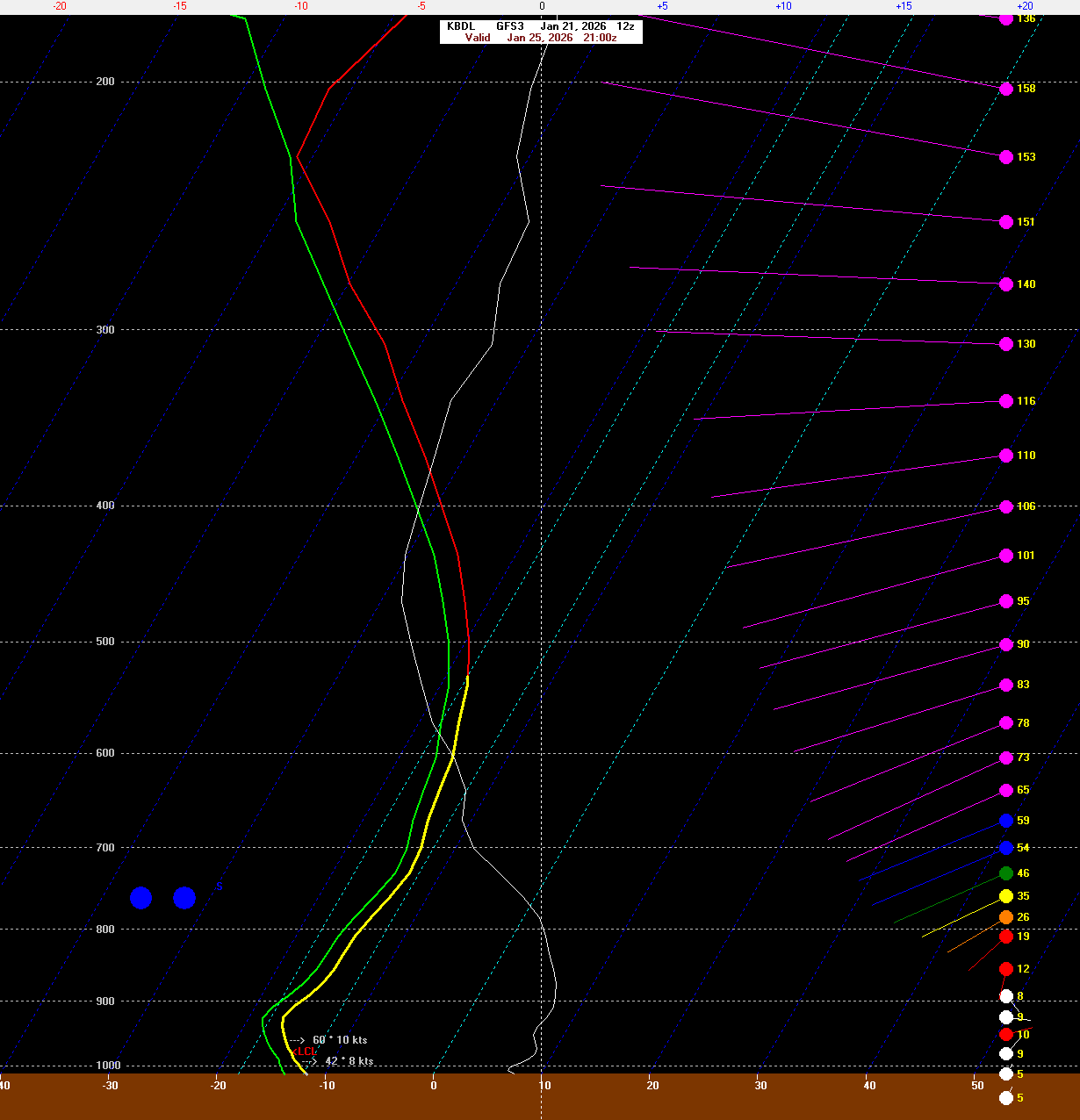
What am I missing on the map below? Thanks!
-
That's a deep DGZ lol
-
 If the low is as far north as CMC/Euro show then I think we are very lucky that we never get above freezing. If it's further south like the GFS then it would be colder.
 -
i'm suspicious that DC will test its all time low temp reading (-14F) that has stood since the late 19th Century.
-
Does the old BUFKIT site still work. I used to have it bookmarked on an old laptop. But cant find it anymore.
-
From what I have seen this morning both the Euro and the GFS do smash the upstate. An inch or 2 of snow, 2 or 3 inches of sleet (the combo of these 2 equates to approx just over an inch of liquid equivalent) with the balance being freezing rain (anywhere from 3/4 of an inch up to well over an inch).
-

January 25-26 Winter Storm Potential
Franklin0529 replied to Ralph Wiggum's topic in Philadelphia Region
Worst case I think would be the CMC. Heavy thump then sleet. I have a hard time seeing this being slop. Not with that cold air in place -
Do one of you fine folks have the time to please post the last 3 or 4 eps snowall means? I am trying to do a comparison. Thank you.
-
Hate to ask a question fully motivated out of my personal interest but where do you think the northern extent of this ice storm (.25+) probabilities lie? Personally I can handle synoptic analysis but thermals hurts my brain.
-
Too early to get into details but the DGZ is like sfc-500 for a time of the euro soundings. Definitely has potential to fluff totals up a bit.
-

January 25/26 Jimbo Back Surgery Storm
Blacksburg Coach replied to Jimbo!'s topic in Southeastern States
EPS -
that sounds nearly picture perfect what we are likely seeing this weekend. Downsloping may "save" the Eastern region.
-
This storm sucks.
-
Now see why Ucinelli have to go and say that today? Lol I mean he co-wrote THE book on these things so it makes you wonder...I mean that would be a massive modeling fail if it happens.
-
Yeah, though the closer you are to the mountains, the deeper the cold wedge is likely to be. Once we get close enough I can start posting some BUFKIT profiles for folks that want them.
-
 I don't see any models showing mixing issues until the main show is over so I don't agree that it's a big concern now but we need the primary low to stop trending north now, there's less wiggle room than there was 24 hours ago. Still a lot of solutions on the table/
 -
Thanks, Gemini.
-
Holy wow - I cannot believe this map because I've never seen temperatures like that around here. In my neck of the woods the lowest I've ever seen the temperature was 1 degree.
-
My wife has a Wal-mart pick up today. We should be good Milk and peanut butter.
-
Rutherford up to Wilkes look like ground zero for ZR with the way it trending. We gotta pray for sleet or we are dealing with serious powergrid issues.
-
Big takeaway is NWS is leaning on euro not handling shallow cold air well at all especially in the valley .
-
Tallied up the amount of storms that are too north, too south, and misses (under 6in across NOVA). 0z 5 Maxes to the south 14 Maxes to the North 3 Misses North; 1 Miss South 12z 5 Maxes to the South 15 Maxes to the North 9 Misses North Unfortunately the data pretty strongly reflects the assumption that the probability decrease is caused by mixing concerns. Lets hope for future runs that 9 misses north comes down.
-
https://apps.apple.com/us/app/crayon-style/id629860673