All Activity
- Past hour
-

3/16/26 Severe Weather Event Thread (Day 2 MOD Risk)
Imgoinhungry replied to Kmlwx's topic in Mid Atlantic
Looks like a bit of a later start per nam and hrrr recent runs? Hopefully no impact to school dismissal. . -

2026 Mid-Atlantic Severe Storm General Discussion
Eskimo Joe replied to Kmlwx's topic in Mid Atlantic
- 256 replies
-
- 1
-

-
- severe
- thunderstorms
- (and 7 more)
-
06z Euro is southeast with the heavy secondary defo band
-
Ready for 1" here and 7" in Harvard. This is RFDs chance to escape the sub 30 club
-
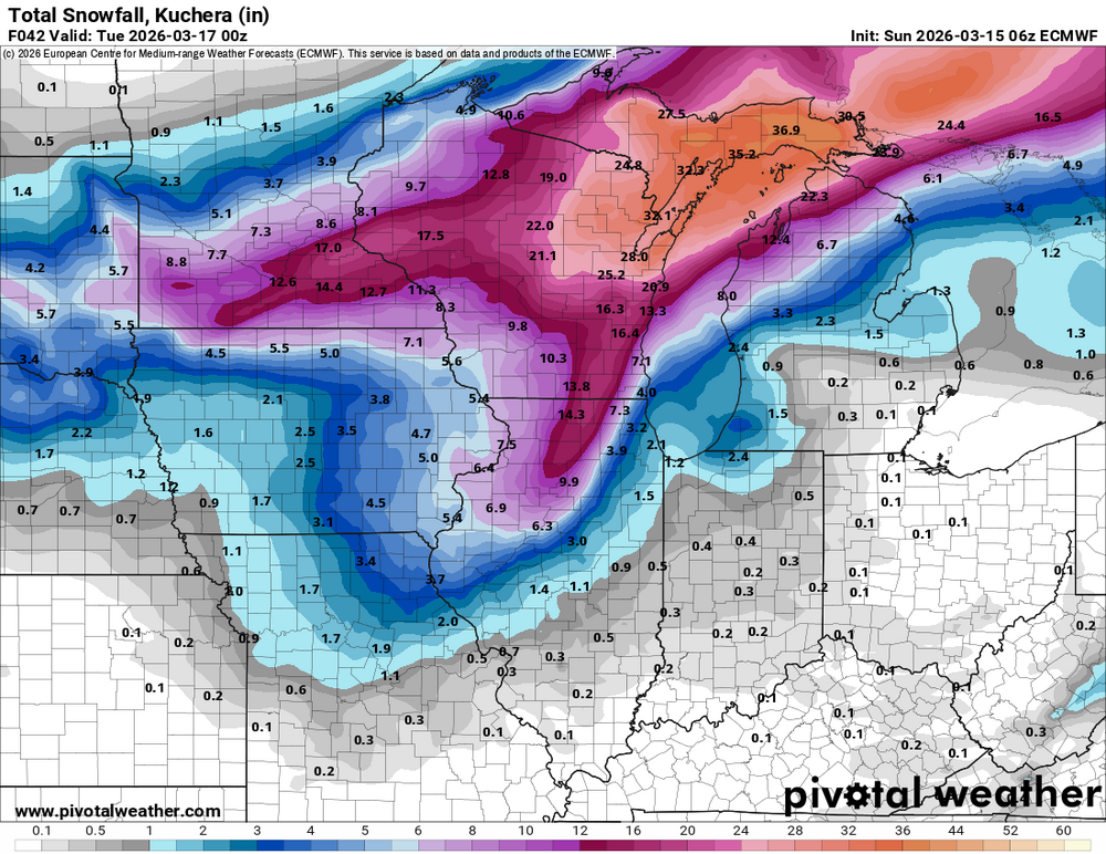
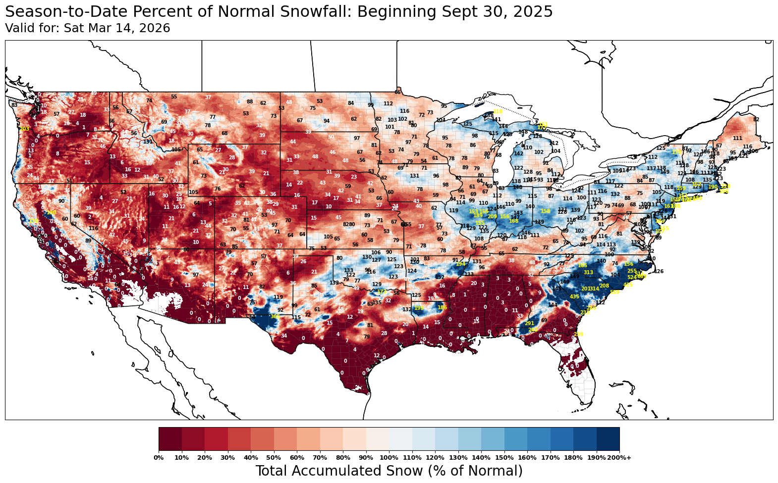
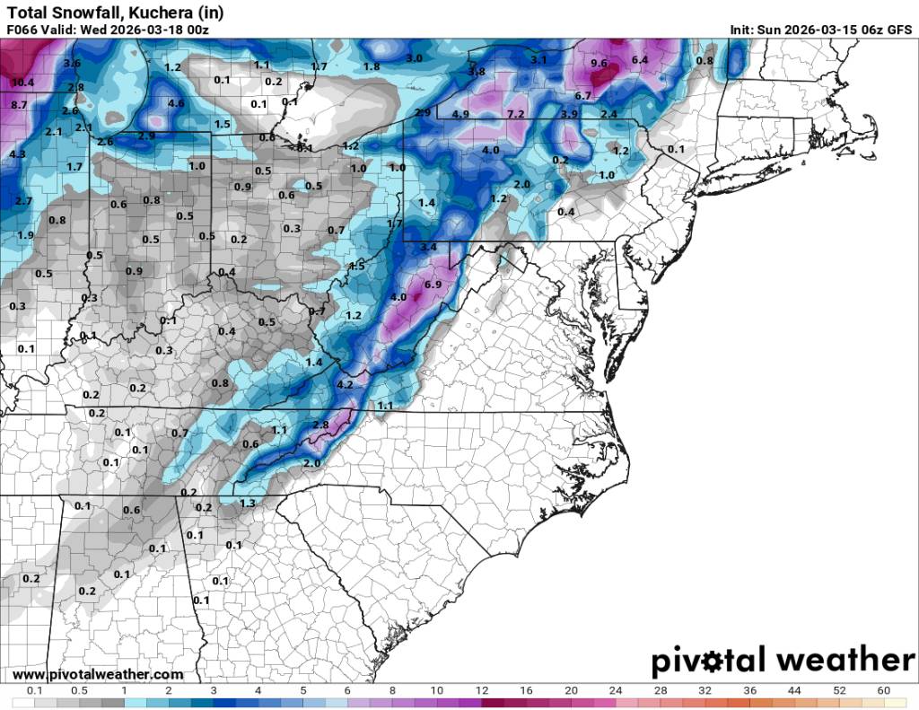
I mainly posted to show the continuing snow hole near State College. It’s difficult for the map generating program to get the grids perfect with such a large gradient involved with the snowfall. This map below has some added numerical percentages. But the resolution is always going to struggle unless you can create a more zoomed in map.

-

3/16/26 Severe Weather Event Thread (Day 2 MOD Risk)
George BM replied to Kmlwx's topic in Mid Atlantic
Well hello there pinned severe thread. First time we've done one since February 25, 2017 IIRC when Ian made one for that event (That event produced an EF-1 in La Plata IIRC). -
Going to be some back to back cold cold nights. Sent from my SM-G998U using Tapatalk
.thumb.jpg.34f6a8572c028dbaeeb0768f5c2a12a4.jpg)
.thumb.jpg.5ac50cc269ee8a9a4cf3ef9ba25ffd41.jpg)
-
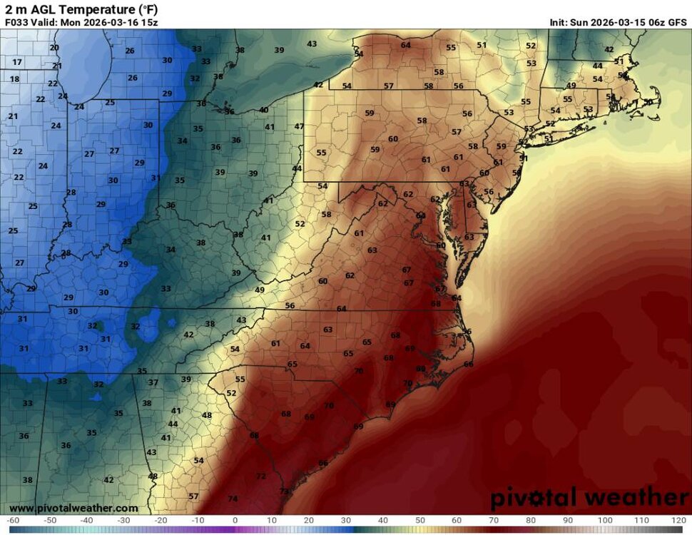
Going to be a huge temp crash tomorrow during the day. Sent from my SM-G998U using Tapatalk
.thumb.jpg.1326cfe19d6d6e19b24f9d6c0285e7b8.jpg)
.thumb.jpg.c7bd2219262c397c7cda8d7afd5e481e.jpg)
-
Looks decent Sent from my SM-G998U using Tapatalk
-
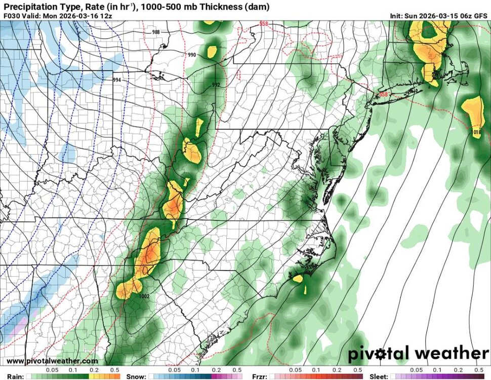
Latest on storms risk on Monday
-
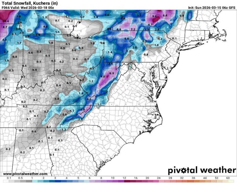
This is a more potent cold front and storm system coming in tonight and tomorrow. Again, we will go from heavy rainfall to snow on the backside, and it looks like we may see some flow snow into Tuesday now. Sent from my SM-G998U using Tapatalk
.thumb.jpg.d2126114b9b5f81b74effe55afe473be.jpg)
.thumb.jpg.f994f06e5e835ba0a6b15b34764ebc36.jpg)
.thumb.jpg.4cb669f2d0a32ddfe3354a7cb0bf0f5b.jpg)
.thumb.jpg.9853eb223d7be7bf344996e3da15a492.jpg)
-
Records: Highs: EWR: 79 (1990) NYC: 77 (1990) LGA: 74 (1990) JFK: 72 (2024) Lows: EWR: 14 (1993) NYC: 14 (1993) LGA: 14 (1993) JFK: 15 (1993) Historical: 1938: A tornado hit McPaul, Iowa, while moving from southeast to northwest. Another tornado raced through Batesville, Illinois, at 60 to 65 mph. Another tornado causing F4 damage killed 10 and injured 12 in St. Clair County, Missouri. This tornado was part of an outbreak that produced four different tornadoes and was responsible for 11 deaths and 42 injuries. 1941 - The most severe blizzard in modern history struck North Dakota and Minnesota. The blizzard hit on a Saturday night while many are traveling, and thus claimed 71 lives. Winds gusted to 75 mph at Duluth MN, and reached 85 mph at Grand Forks ND. Snow drifts twelve feet high were reported in north central Minnesota. A cold front traveling 30 mph crossed Minnesota in just seven hours. (15th-16th) (David Ludlum) (The Weather Channel) 1987 - A winter storm in the western U.S. produced heavy snow in central Nevada, with 23 inches reported at Austin. High winds raked the desert areas of southern California and southern Arizona. Winds gusted to 59 mph at Douglas AZ. (The National Weather Summary) (Storm Data) 1988 - More than one hundred hours of continuous snow finally came to an end at Marquette MI, during which time the city was buried under 43 inches of snow. Unseasonably cold weather prevailed in the southeastern U.S., with forty-one cities reporting record low temperatures for the date. (The National Weather Summary) (Storm Data) 1989 - Afternoon and evening thunderstorms produced severe weather from Alabama to the Middle Atlantic Coast. Thunderstorm winds gusted to 80 at Virginia Beach VA. Low pressure in southeastern Ontario produced high winds in the northeastern U.S. Winds gusted to 70 mph at Saint Albins VT. (The National Weather Summary) (Storm Data) 1990 - Low pressure crossing the Upper Mississippi Valley produced high winds from the Northern and Central Plains to the Great Lakes Region and Ohio Valley. Winds gusted to 73 mph at Iowa City IA, and wind gusts reached 79 mph at Waukesha WI. Winds of 75 mph were reported around Rapid City SD, with gusts to 100 mph. Up to a foot of snow was reported in western Iowa, western Minnesota, and extreme eastern North Dakota. Blizzard conditions were reported in northeastern North Dakota and northwestern Minnesota. (The National Weather Summary) (Storm Data) 1990: The maximum temperature for the date is 81 °F in Washingon, DC.(Ref. Washington Weather Records - KDCA) Cherry blossoms peak earliest ever around Tidal Basin (Bob Ryan's 2002 Almanac) 1992: Intense snow squalls that began 3 days earlier finally came to an end over Oswego and Onondaga counties in central New York. Palermo was buried under an incredible 85 inches of snow over the four day period. Parish checked in with 60 inches and Fulton recorded 51 inches. (Ref. Wilson Wx. History) 1993: Record low minimum temperature of 8°F for March recorded at Annandale-Barcroft Hills Station after the blizzard of March 13th. (Ref. Annandale Weather Records) The minimum temperature for the date is 15 °F in Washingon, DC. (Ref. Washington Weather Records - KDCA) New Orleans, LA dropped to 31° to break their old record by 9 degrees as cold air remained in place over the East in the wake of the "Superstorm". Fort Myers, FL dropped at 39°. (Ref. Wilson Wx. History) 1994: 9 inches of snow on this day brought the seasonal snowfall total at Binghamton, NY to 123.2 inches, the city's snowiest winter ever. (Ref. Wilson Wx. History) 1997: Marquette, MI established their record for greatest snow depth with 63 inches on the ground. (Ref. Wilson Wx. History) 1999: Billings, Montana: A record wind gust of 63 mph for March is recorded at Billings. The old record, 61 mph, occurred in 1956. (Ref. WxDoctor) 2004: Brownsville, Texas, breaks a century-old record for the most significant daily rainfall accumulation for March with 3.23 inches.
-
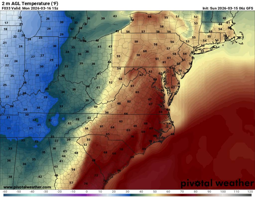
37 / 20 . Cloudy - stuck in the 40s. Lake cutting storm pumps southerly flow later tonight and tomorrow ahead of front. Pending on clouds and rain ahead of the main front, areas could get to 70. Strong storms Monday - heavy rai , winds gusts , further southwest enhanced to moderate risk w/ islolated tornadoes. Area wide 1 inch of rain between sun night and overnight mon - tue. Could see some power disruptions with winds/wet grounds etc. Colder : 3/17 -3/18. Overall near normal / slightly cooler 3/ 19 - 3/24 before moderation warmer overall but still a bit back and forth and uncertain extent of ridge / warmth.
-
North Georgia may see some flakes in the air. I wouldn't expect anything to lay down there this time of the year. But yeah some blowing snow sure.
-

3/16/26 Severe Weather Event Thread (Day 2 MOD Risk)
dailylurker replied to Kmlwx's topic in Mid Atlantic
Very impressive setup. Especially for March. Looks like a pretty exciting event. I still wish I was up in the UP for the blizzard. If I wasn't back to my busy season I would be up in Marquette right now. -
You might be closer to 45-50
-
2026 Mid-Atlantic Severe Storm General Discussion
Eskimo Joe replied to Kmlwx's topic in Mid Atlantic
SPC mentioning the potential for a long track tornado or two. Oh man. -
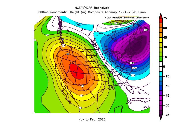
Our summer forecast will probably come down to how far east this ridge can expand since it has been stuck in place since November. This month we are getting dual ridges out West and in the East. Could be some very impressive summer warmth expanding across the CONUS if we get a similar linking up between the ridges like we have had this month. But the magnitude of the coming Western warmth will be higher than in the East even though several spots like NYC experienced their earliest 80° warmth on record.
-
Ours came out last week the first day of that warm spell. I heard it just a few the first day of the I'm warm spell... The next day it was like a symphony.
-
Was wondering if peepers would get going soon
-
Birds are now here in full effect. Also noticed the peepers a couple nights ago. only the largest snowbanks are left here. No ground cover.
-

3/16/26 Severe Weather Event Thread (Day 2 MOD Risk)
SomeguyfromTakomaPark replied to Kmlwx's topic in Mid Atlantic
Wow, haven’t seen this in a while. Maybe August 2023 was the last moderate risk day here? At least the QLCS holds off until after school dismissal and kids have a chance to get home. -
Well that was a swing and a miss for MSP. Idk what it’ll take to get a storm to live up to the hype around here. .
- Today
-
Happy to have nothing to do with this one on Selection Sunday March 15th is for 65 degrees and day drinking. Hard pass on any snow.
-
Very active Monday likely. If we get higher dews/temps and more sun than forecast then wind/tornado threat goes way up


.jpg.2600828088bfb137225aecca456ca9d4.jpg)
.jpg.f16e795eac6bd9d762c42fcc327f9ad4.jpg)
.jpg.8d79dd88ec4041e0674b41ecd6be1d47.jpg)
.jpg.e0713078267bf8fd67f6dc8536b67d75.jpg)


.jpg.2a3ff079b929b0c6e3a16d06ecf731f1.jpg)
.jpg.eb767b0de617b4fcd40175a60f9f0078.jpg)
.jpg.b18b52617949a54eae1f0230ac2a1ca5.jpg)
.jpg.69b34e63074e9b7fcc3da3e864e495de.jpg)


