All Activity
- Past hour
-
double the speed, 4x the kinetic energy and also 4x the drag force on objects.
-
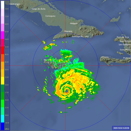
Pressure has dropped to 947 mb, so intensification has resumed.
-

Mid to long range discussion- 2025
WinstonSalemArlington replied to wncsnow's topic in Southeastern States
Cold AF -
IMO an ERC down the road wouldn’t be likely anyways. As it gets closer to the coast and higher terrain, the core is likely to tighten up with frictional convergence.
-
60 knot increase from 5AM EDT Saturday’s 60 knots to 5AM today’s 120 knots!
-
We can't underestimate the WDI. Sometimes it just happens. It's been several years since I've broken the 20" mark for a season. That's nuts where I'm located at the base of the Catoctins at over 750ft in elevation. Some were from just dreg winters and some was just bad luck. The WDI is running pretty high.
-
61 / 39 great fall day
-
DCA's heat island has kept increasing. Their last subfreezing temp in October was in 1992; before that you have to go back to the famously cold October 1976, the prequel to the brutal winter of 1977.
-
Was that an intensification of 50 kt to 120kt in 24 hours? Or am I wrong?
-

Spooky Season (October Disco Thread)
kdxken replied to Prismshine Productions's topic in New England
Add "thread the needle" and you know it's going to suck. -
That's what I'm thinking and why I think RI halted for now. This would be bad timing for EWRC because it would have time to intensify again before landfall and expand the wind field.
-
I think this would actually be bad timing for an ERC. If anything, you want it close enough to landfall that it can’t rebound from its peak. A cycle now would just expand the wind field and effectively give Melissa 24 hours to potentially RI again. Note how the 06z HAFS both intensify upon final approach.
-
Could be the start of an EWRC
-
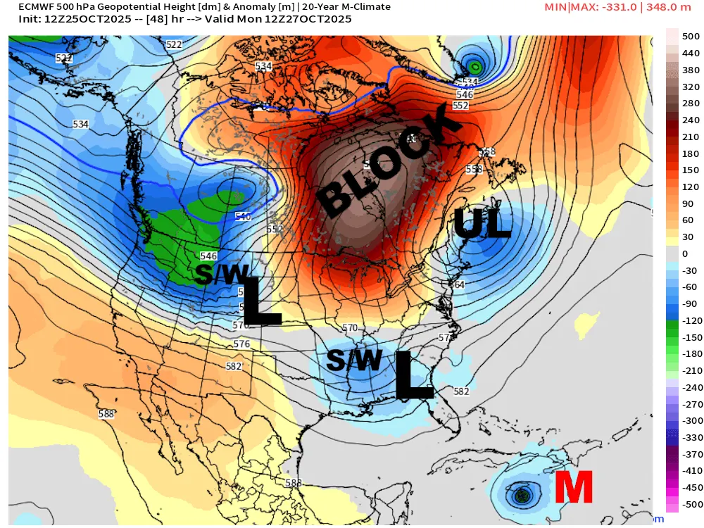
Bookmarking this for reference. Boy, what I'd give for this look in a couple months!
-
.thumb.png.4150b06c63a21f61052e47a612bf1818.png)
Spooky Season (October Disco Thread)
HIPPYVALLEY replied to Prismshine Productions's topic in New England
Yeah, I hate to see the “we need major changes” and “this run’s not going to get it done” posts in DJF. -
Spooky Season (October Disco Thread)
HIPPYVALLEY replied to Prismshine Productions's topic in New England
Mid 50s in the valley already. Even have the windows open while I vacuum. -
At a 40th party now but I will get a tracker thread going for Thursday-Friday. Moderate impact 12 hour event 1-3 inches, all the other parameters mentioned earlier today. I just need computer time at home to phrase carefully. Should see the thread at 6pm. Have seen 12z/26 gfs and cmc ops. remember this is D5. Lots can go awry so let’s be a little cautious on anticipating too much wind and rain.
-
We have seen Caleb Williams cry. Raven's defense needs to make him want to cry today. Let him be comfortable in the pocket, and he has the arm talent to make you pay.
- Today
-

Spooky Season (October Disco Thread)
CoastalWx replied to Prismshine Productions's topic in New England
0.0% chance of new england impacts. -
I believe in the WDI. The PDO? Eh, just hope for less hostility, which it seems to be trending towards. Kind of aligns historically- a weak cold ENSO should correlate to a weakly negative PDO. Bottom line is if we have periods with a +PNA and/or -EPO, and get a little help in the NA, we should have cold shots with storm chances. The rest is luck with timing waves, as always.
-
Wouldn't a scenario like that be more likely for Philly.to NE though? Hard to see us getting warning snowfall from a coastal in a nina. I mean the same dynamic is at play each time, isn't it?
-

Spooky Season (October Disco Thread)
WxWatcher007 replied to Prismshine Productions's topic in New England
I think I can speak for everyone when I say I’d rather have my Christmas tree and all the presents catch fire than watch @ORH_wxman chime in a tracking thread with “we need major changes”. -

Central PA Fall Discussions and Obs
Mount Joy Snowman replied to ChescoWx's topic in Upstate New York/Pennsylvania
Noticed that, interesting indeed. I think sometimes when the inversions are quite shallow that I sit juuuuust above them at my new location. I say “new” even though we’ve been here going on three years ha, but our last place sat about 100’ lower and I got noticeably colder lows over there. -
Lots of cooling near Japen of late.
.png.0e861007bbfffbf1a3daa3e0387c5221.png)
-

2025-2026 ENSO
donsutherland1 replied to 40/70 Benchmark's topic in Weather Forecasting and Discussion
Here's a link: www.jamstec.go.jp/virtualearth/general/en/graph_SINTEX.html#emi


