All Activity
- Past hour
-

The return of the elusive Nor'easter. Drought buster or bust?
dailylurker replied to dailylurker's topic in Mid Atlantic
It's clearing up out here alone the Blue Ridge. It might be a nice day out this way. Good job NAM lol -
I haven't been through there yet. Roundabouts are definitely something people need to get used to but they are much more effective at moving traffic, and safer once people get used to it as there are much less potential collision points. There are a number of other more effective and safer designs for intersections/interchanges that are finally startingto get implemented more these days. Unfortunately people don't like change and like to complain so many won't be happy unless they are sitting still at a red light in a tradition intersection.
-
Beginning to think it may not frost this month for our area.
-
Getting pretty breezy now..
-
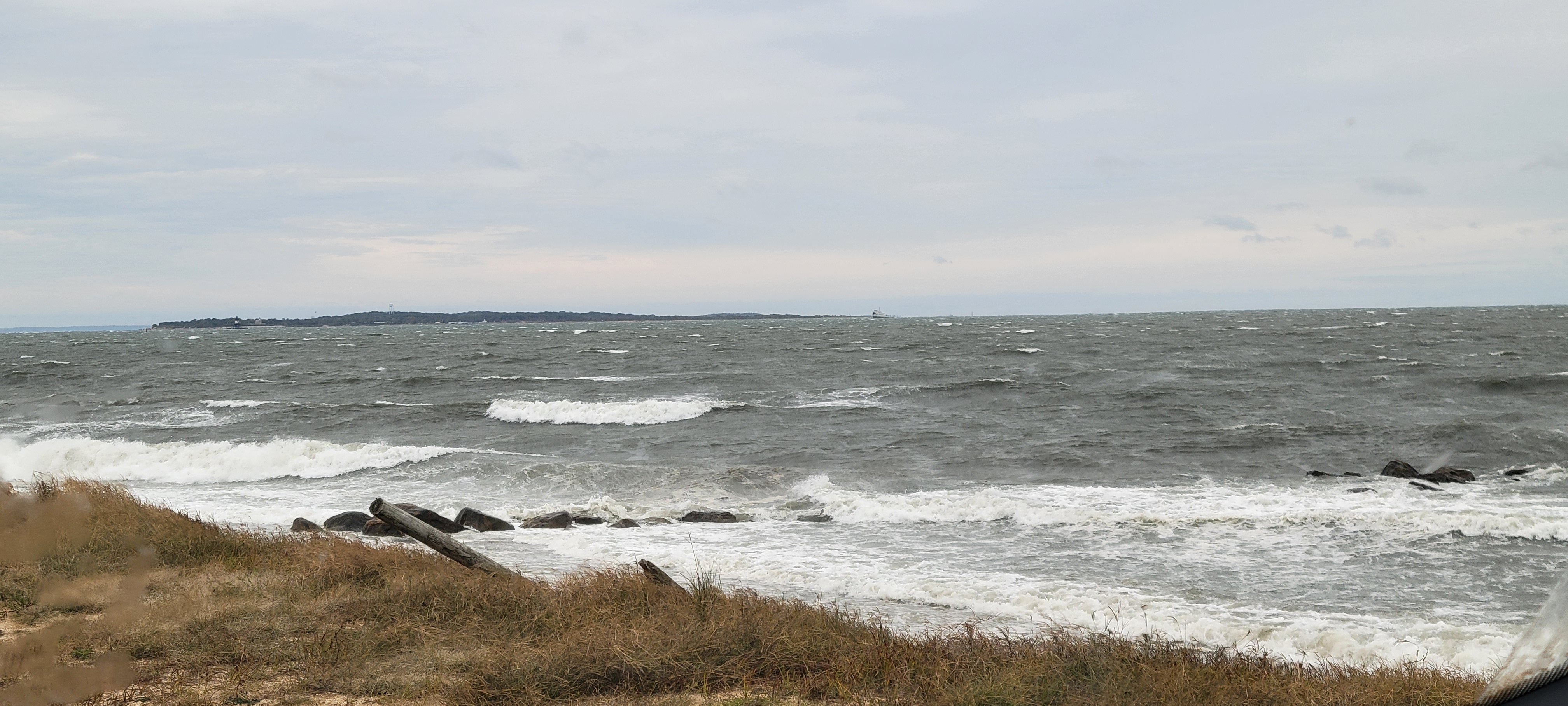
 33 mph gust so far, tides are running much higher versus all week so far low tide is now with first high tide about 3 pm today. Waves out here on the east end are quite impressive 2-4 feet( I'm very bad with guessing wave heights) plenty of white caps. Cross sound ferry to be London still running, for now but I expect them to cancel boats soon! Winds are deft increasing. The trees are screaming with all the leaves still on them.... Setup is deft there for decent power outages, especially areas that haven't had lines or poles upgraded since sandy. Let's not forget, prolonged dry/ drought on top of bugs or diseases will allow trees to be compromised/ weak.
 -

The return of the elusive Nor'easter. Drought buster or bust?
mappy replied to dailylurker's topic in Mid Atlantic
lol what happened? Thought it was going to be a rainy Sunday? -
I thought it weird that they did this whole big project but seemingly only raised the roadway a foot or so. The new configuration of the circle seems to be confusing a lot of drivers too.
-
Continuation of the warm ups being more impressive than the cold downs across the area.

-

Central PA Fall Discussions and Obs
mahantango#1 replied to ChescoWx's topic in Upstate New York/Pennsylvania
.34 for the event so far. -

Central PA Fall Discussions and Obs
canderson replied to ChescoWx's topic in Upstate New York/Pennsylvania
.11” yesterday evening - looks like I might not even double that for this event. -
Yeah. But at least it is mildly interesting. And we need the rain
-
Records: Highs: EWR: 88 (1954) NYC: 86 (1954) LGA: 86 (1954) JFK: 83 (1969) Lows: EWR: 35 (1996) NYC: 35 (1876) LGA: 41 (1964) JFK: 38 (1996) Historical: 1836 - A third early season storm produced heavy snow in the northeastern U.S. Bridgewater NY received 18 inches, a foot of snow fell at Madison NY, and for the third time all the mountains of the northeastern U.S. were whitened. (David Ludlum) 1906: Charlotte, NC recorded its' earliest freezing temperature with a morning low of 31°. (Ref. AccWeather Weather History) 1918 - Forest fires ravaged parts of Minnesota from the Duluth area northeastward, claiming the lives of 600 persons. Smoke with a smell of burnt wood spread to Albany NY and Washington D.C. in 24 hours. Smoke was noted at Charleston SC on the 14th, and by the 15th was reported in northeastern Texas. (David Ludlum) (The Weather Channel) 1918: On October 10, 1918, two men working near a railroad siding northwest of Cloquet, Minnesota, saw a passenger train pass by the siding, and soon after, that discovered a fire burning through grass and piles of wood. The fire could not be contained, and by October 12, fires had spread through northern Minnesota. At least 450 lives were lost, and 52,000 people were injured or displaced, 38 communities were destroyed, 250,000 acres were burned. 1942: A tropical storm moved in across eastern North Carolina into central Virginia on October 12, 1942. Torrential rains fell from October 12-16 in Northern Virginia and Maryland. It caused the worst river flood in the history of the Virginia and DC. The hardest hit was the mid portion of the Rappahannock River and the Shenandoah River. On the Rappahannock, damages came to $2.5 million (1942 dollars) and most of that was in Fredericksburg, where the river rose to 41 feet (27 feet above flood stage). On the Shenandoah River, a stage of almost 50 feet was reached at Riverton on the morning of the 16th. Flood stage is 22 feet and it broke the record set by the March 1936 flood by 12 feet! The Potomac at Washington reached 17.6 feet (flood stage is seven feet). Areas of Alexandria and Arlington were seriously flooded. The Anacostia River flooded as well as 6 feet of water was across the boulevard in Bladensburg. Ten to 12 inches of rain fell from Fredericksburg to Warrenton. Seventeen inches were recorded in Front Royal. In Shenandoah National Park, along Skyline Drive, rainfall totals reached 18 to 19 inches. To the south, Nelson County received 16 inches. Another maxima of 12 to 16 inches fell from near Paw Paw, West Virginia south along the Shenandoah Mountains to west of Harrisonburg. About 6 to 8 inches fell over much of central and western Maryland. Highways and bridges were washed away across the region. Over 1,300 people were left homeless in Albemarle, Spotsylvania, Stafford and Warren Counties in Virginia. About 750 people were displaced from homes in Maryland. Hundreds of homes were flooded in Georgetown. Miraculously, only one person died. Transportation was interrupted for three days. Severe damage occurred to crops: peanuts, cotton, sweet potatoes, soybeans, shocked corn and late hay. The heavy rains caused a million bushels of apples to drop before they were picked. 1942 Storm Track - Underground Weather 1962 - The "Columbus Day Big Blow" occurred in the Pacific Northwest. It was probably the most damaging windstorm of record west of the Cascade Mountains. Winds reached hurricane force, with gusts above 100 mph. More than 3.5 billion board feet of timber were blown down, and communications were severely disrupted due to downed power lines. The storm claimed 48 lives, and caused 210 million dollars damage. (David Ludlum) 1950: Charlotte, NC recorded their latest 90° reading ever. (Ref. Wilson Weather History) 1954: Boston, Massachusetts had a maximum temperature of 90 °F the highest temperature for October. They also had 90 °F on October 7th 1963. (Ref. NOAA Boston Weather Events) 1962: The Columbus Day Storm of 1962 was a Pacific Northwest windstorm that struck the West Coast of Canada and the Pacific Northwest Coast of the United States. It is considered the benchmark of extratropical wind storms. The storm ranks among the most intense to strike the region since at least 1948, likely since the January 9, 1880 "Great Gale" and snowstorm. Click HERE for more information from the University of Washington. 1979: The lowest barometric pressure ever recorded occurs in the center of Typhoon Tip on this day. A fly reconnaissance mission recorded the low pressure of 870 hPa or 25.69 inHg. Typhoon Tip was the most extensive tropical cyclone on record with a wind diameter of 1380 miles at its peak. 1981: Hurricane Norma crossed from the Pacific over Mexico and into Southwestern Texas. 25.00 inches of rain fell in the area around Gainesville and Bridgeport, TX. The elephant from the Gainesville Zoo reportedly survived the massive flooding by holding its trunk above the water. (Ref. Wilson Weather History) 1987 - Floyd, the only hurricane to make landfall the entire season, moved across the Florida Keys. Floyd produced wind gusts to 59 mph at Duck Key, and up to nine inches of rain in southern Florida. Sixteen cities in the Ohio Valley and the Middle Mississippi Valley reported record low temperatures for the date. Record lows included 27 degrees at Paducah KY, and 24 degrees at Rockford IL and Springfield IL. (The National Weather Summary) (Storm Data) 1988 - Twenty cities in the Upper Midwest reported record low temperatures for the date, including International Falls MN with a reading of 17 degrees. The town of Embarass MN reported a morning low of 8 degrees. Snow showers in the northeastern U.S. produced five inches at Corry PA. (The National Weather Summary) (Storm Data) 1989 - Temperatures again warmed into the 80s in the Central Plains Region and the Middle Mississippi Valley, with 90s in the south central U.S. Six cities reported record high temperatures for the date, including Fort Smith AR with a reading of 92 degrees. Strong winds along a cold front crossing the Great Lakes Region and the Ohio Valley gusted to 61 mph at Johnstown PA. (The National Weather Summary) 2005: On this date through the 14th, on its way to setting a local record for the month, Central Park in New York City received 8.5 inches of rain over the 3-day period. 16.73 inches fell during October to eclipse a 102-year record. (Ref. Wilson Weather History) 2006: With 0.3 inches of snow falling at O'Hare International Airport, giving Chicago its earliest measurable snowfall. The previous earliest date was 10/18/1972 and in 1989.Snow Trivia for Chicago - NWS (Ref. WxDoctor) 2008: Montana, Wyoming, and Idaho from the 10th to the 12th: A significant winter storm brings heavy snowfall to areas of Montana, Wyoming, and Idaho over three days. The city of Red Lodge, Montana records its highest 24-hour snowfall total with 42 inches of snow. Glasgow, Montana also sets a new October 12th record when 12.8 inches of snow falls. (Ref. WxDoctor)
-

Central PA Fall Discussions and Obs
Mount Joy Snowman replied to ChescoWx's topic in Upstate New York/Pennsylvania
Low of 56 with .16” of rain. Regardless of amounts, the grass will love these conditions. -

The return of the elusive Nor'easter. Drought buster or bust?
Weather Will replied to dailylurker's topic in Mid Atlantic
NWS should decommission the NAMs early. They are an embarrassment. -

2025 Atlantic Hurricane Season
LawdogGRNJ replied to BarryStantonGBP's topic in Tropical Headquarters
It gets worse...now there's evidence of Jerry meandering in the Atlantic. -
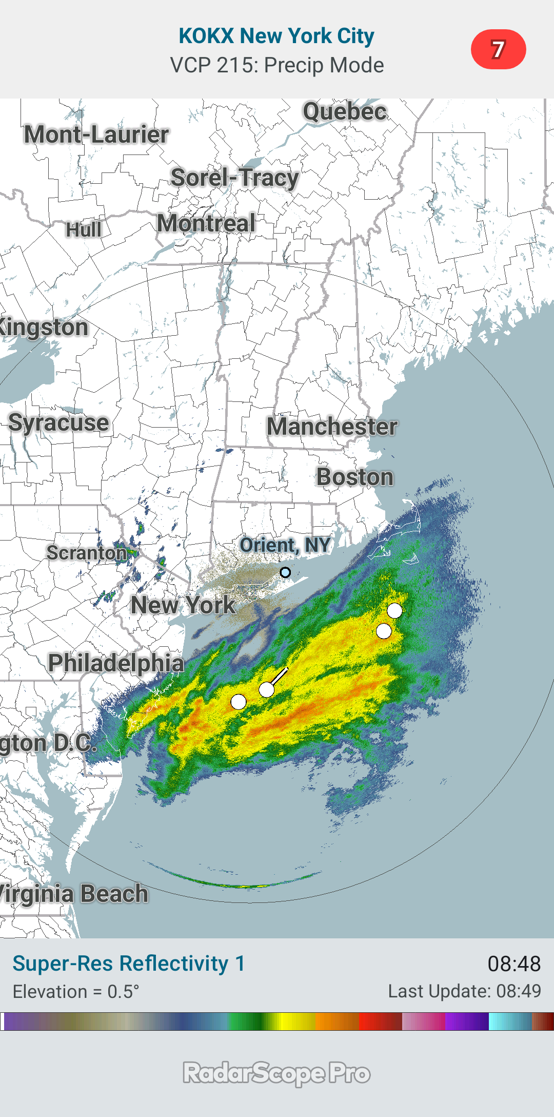
62 / 52 24 hours into the C+C (Cutoff / Coastal) cloud factory and 0.09 of rain. Much discussed long running storm to dump 1 - 3 inches of rain - more east. Clear out by later Tue evening. Dry much cooler Wed - Thu, perhaps some frost inland. Much warmer by next weekend and 70s look to return one or both weekend days 10/18-19. Overall near / slightly abovr normal beyond there.
-
 Two day total of 0.13" so far...
 -
Man it has been a boring stretch lately, I mean I guess the other shoe drops and we have an active winter but it has been quite a quiet run.
-
Through October 10th, 2025 has the 3rd warmest start to October globally on the ERA-5 dataset. The five warmest October 1-10 periods are: 1. 15.72°C, 2023 2. 15.59°C, 2024 3. 15.45°C, 2025 4. 15.38°, 2015 5. 15.30°C, 2020 With the warm global forecast (generally 0.8°C-1.0°C) on the ECMWF weeklies, there is a growing chance that 2025 could join 2023 and 2024 as the only years with an October mean temperature of 15.00°C or above.
-
somewhere on the south shore is getting 5-6"
-

The return of the elusive Nor'easter. Drought buster or bust?
BlizzardNole replied to dailylurker's topic in Mid Atlantic
Pretty much! But hey we get to practice our base state of clouds, drizzle and wind that we'll be treated to for five months starting soon -
The return of the elusive Nor'easter. Drought buster or bust?
dailylurker replied to dailylurker's topic in Mid Atlantic
I'm in an Airbnb at 1000' elevation on the western side of South Mountain. It's been pretty rainy here since last evening around 11 when the rain ran us inside and put out our fire. Rainy dreary morning here. It looks pretty dry everywhere else.