All Activity
- Past hour
-

Richmond Metro/Hampton Roads Area Discussion
migratingwx replied to RIC Airport's topic in Mid Atlantic
The problem is, it lags a cycle or so behind so it's using old data and still catching up. -

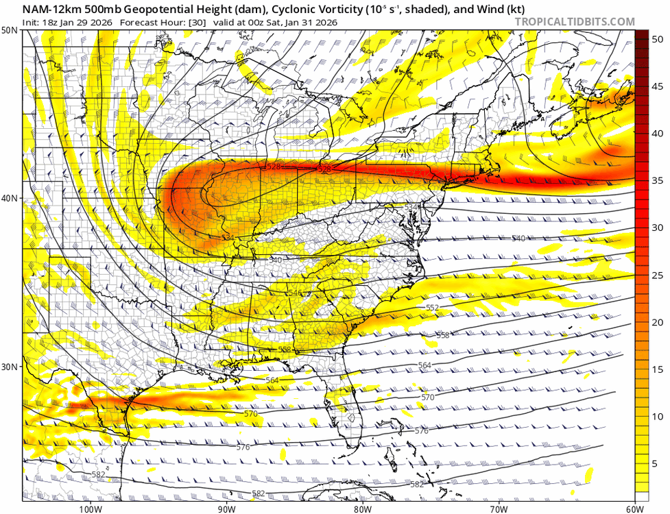
The Jan 31 Potential: Stormtracker Failure or 'Tracker Trouncing
Eskimo Joe replied to stormtracker's topic in Mid Atlantic
I'll bet my bottom dollar that gets upgraded to a Blizzard Warning. -

The “I bring the mojo” Jan 30-Feb 1 potential winter storm
Ravens94 replied to lilj4425's topic in Southeastern States
-
I don't think so, except maybe 2/6/1978. Or maybe they just got lucky then.
-

Possible coastal storm centered on Feb 1 2026.
HoarfrostHubb replied to Typhoon Tip's topic in New England
I’ve had some melting of the snow on my roof. Icicles starting and some ice forming on my front steps where it has dripped a bit. I also watched yesterday morning, once the sun rose, as the dusting of snow on my daughter’s car disappeared in about an hour (sublimation). it’s happening, just slowly -

Richmond Metro/Hampton Roads Area Discussion
Sernest14 replied to RIC Airport's topic in Mid Atlantic
Just ChatGPT’d the map and it basically downgraded everything the nbm shows for this area. Pretty interesting read. Asked it what ratios are used and why it shows so high compared to many models tha show 0-1” -
The “I bring the mojo” Jan 30-Feb 1 potential winter storm
Ravens94 replied to lilj4425's topic in Southeastern States
I agree should result in a more negative tilt since its held back/west we will see! -

The “I bring the mojo” Jan 30-Feb 1 potential winter storm
Upstate Tiger replied to lilj4425's topic in Southeastern States
Funny seeing the cliff diving for those not getting 10”. I’m 61 and followed winter weather since 1976. The only 10” storms I remember in the upstate were the PD 1 1979, March 1983, and January 1988. Point being, it’s a rare thing to get 10” of snow in the SE. -
Temp was tanking and then the wind picked up a bit went from 16 to 20.
-

Winter 2025-26 Medium/Long Range Discussion
RogueWaves replied to michsnowfreak's topic in Lakes/Ohio Valley
Those that are skilled in pattern recognition (I am not) plus the repeating winter pattern(s) are keying-in on the period from approximately February 10th and the two weeks after as a recurrence of the first half of December. Aka that nice CO Low that hammered IA, IL and some surrounding states followed by sustained BN temp regime. This season has seriously mimicked last winter in many ways and last season I had my biggest storms on 2/8 and again 2/12-13. The 2/15-16 sytem for which I was under a WATCH for one shift, ended-up sliding SE and nailing TOR. That box has already been checked this winter with last weekend's major. I would not snooze on this upcoming period, tho p'sure the bulk stay south of mby yet again. -

The “I bring the mojo” Jan 30-Feb 1 potential winter storm
Snowncanes replied to lilj4425's topic in Southeastern States
Speculation, but could let the southern energy round the bottom of the trough and beat the cutoff. Would help pull the low in closer -

Winter 2025-26 Medium/Long Range Discussion
Powerball replied to michsnowfreak's topic in Lakes/Ohio Valley
I see you ruffled some feathers with this questions and triggered an individual who's seeking attention (won't name names...). But that person's issues aside, people like what they like and hate what they hate. It is what it is I will say, warm weather states have been the fastest growing part of the US for over 4 decades with no signs of slowing down (many southern cities/metro have already or soon will surpass a lot of cold northern cities/metros in population) so there's actually a lot more people than yo think in the real world that can also do without "deep winter." Just have to remind yourself, weather forums can be a bit of an echo chamber that isn't always reflective of the majority opinion. -

1/30-1/31 Lake Effect Snow Threat - SE WI, NE IL, and NW IN
mimillman replied to A-L-E-K's topic in Lakes/Ohio Valley
Not hating these hi res trends for NE IL -

E PA/NJ/DE Winter 2025-26 Obs/Discussion
Kevin Reilly replied to LVblizzard's topic in Philadelphia Region
Gotta be broken right? -

The Jan 31 Potential: Stormtracker Failure or 'Tracker Trouncing
AlexD1990 replied to stormtracker's topic in Mid Atlantic
ratios are messed up on the NBM. also fuck this storm, its the meteorological equivalent of herpes. -
The “I bring the mojo” Jan 30-Feb 1 potential winter storm
Ravens94 replied to lilj4425's topic in Southeastern States
The block is even stronger in the NE so its essentially slowing the trough. This will be interesting to watch its definitely different at 500 -
Those monk Parakeets do fine up here in nj in the cold.
-
E PA/NJ/DE Winter 2025-26 Obs/Discussion
Kevin Reilly replied to LVblizzard's topic in Philadelphia Region
Slightly warmer tonight so far here currently 14f dew point 1f this time last night it was 8f dew point -4. It’s all relative at this point but this is the coldest I remember going back to the later 1980s. -

Possible coastal storm centered on Feb 1 2026.
CoastalWx replied to Typhoon Tip's topic in New England
Yah -

The “I bring the mojo” Jan 30-Feb 1 potential winter storm
HKY_WX replied to lilj4425's topic in Southeastern States
I might actually agree with this. I haven't really seen it oscillate at all, with regards to QPF location. Just up/down with amounts. -
How about the parrots.
-
Possible coastal storm centered on Feb 1 2026.
CoastalWx replied to Typhoon Tip's topic in New England
That dude is in northern ORH county lol. -
The “I bring the mojo” Jan 30-Feb 1 potential winter storm
Snowncanes replied to lilj4425's topic in Southeastern States
Yeah thats a big change for 12hr… wonder how it changes downstream. Must’ve had some recon ingested. -
The “I bring the mojo” Jan 30-Feb 1 potential winter storm
Aleksey replied to lilj4425's topic in Southeastern States
I agree with the Atlanta and metro area, but not out towards winded. 0.3” QPF with 15:1 to 20:1 ratios. Athens will most definitely be getting hit hard with 3-6”. West of Barrow county is where QPF will be super low and around 0.1”. Athens looks to be at 0.3”-0.4” of QPF which would easily lay down 3-6”. The cutoff is west of Barrow into mid Gwinnett. . -

E PA/NJ/DE Winter 2025-26 Obs/Discussion
Birds~69 replied to LVblizzard's topic in Philadelphia Region
I would take that in a heartbeat...


