All Activity
- Past hour
-
A few re-edits and new shots from the other night and following morning:
-
(002).thumb.png.6e3d9d46bca5fe41aab7a74871dd8af8.png)
E PA/NJ/DE Winter 2025-26 Obs/Discussion
ChescoWx replied to LVblizzard's topic in Philadelphia Region
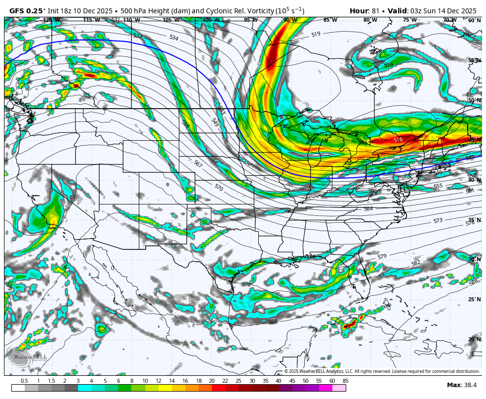
GFS did move north a bit from it's 6z run...but still south of some of the other models.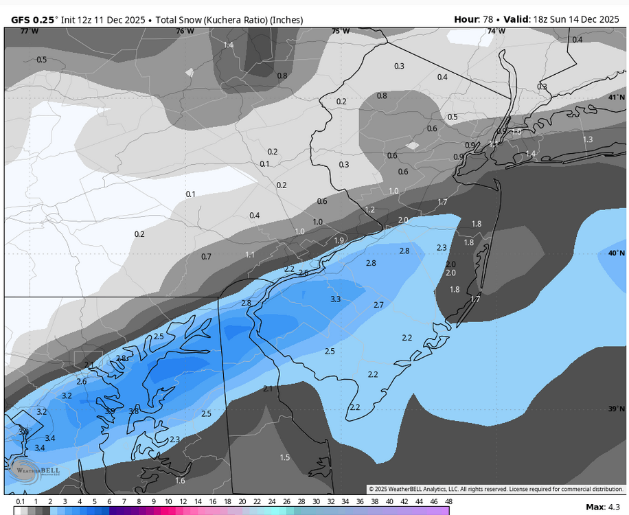
-

December 2025 regional war/obs/disco thread
Sey-Mour Snow replied to Torch Tiger's topic in New England
Tick tick tick
-
I’d like to know what snow gods we pissed off. It feels like we are going for the golden sombero at this pace.
-
That's the worst penis i have ever seen.
-
Seems like we got NAM/Rgem the most north, gfs the most south and euro and icon in between
-

December 2025 regional war/obs/disco thread
40/70 Benchmark replied to Torch Tiger's topic in New England
Is the GFS as interested in SNE snow as the Sox were in Alonso? -
The few events we've had favored areas that cash in on a NW wind direction. The Bentleyville/Solon area seems to be ground zero. Payback for all the events that have a due westerly wind we miss out on
-
Man... the GFS has been rock solid
-
Yeah. This is tough to even get too excited about yet. Basically a Nowcast of where that thing even sets up.
-

Minor snow possible sunday 12/14/25
snowman19 replied to WeatherGeek2025's topic in New York City Metro
The RGEM pivotal map I linked was 10:1 ratios -
Mostly a south coast and cape scraper on GFS but another bump would make it pretty decent if we can get that trend going rather than just oscillating between scrapers and whiffs on this model.
-
Snowfall is rapidly decreasing, except for high latitudes.
-

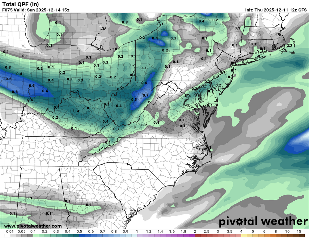
12/14: Sunday funday? Will the south win again?
NorthArlington101 replied to TSSN+'s topic in Mid Atlantic
GFS pretty steady - very slight tick north but it's got such a tight band every tick matters I guess. ninja'd x2 -
Develops over the region on the GFS.
-

Central PA Winter 25/26 Discussion and Obs
Itstrainingtime replied to MAG5035's topic in Upstate New York/Pennsylvania
Loving all of the wintry scenes being posted. So far I'm living vicariously through them. -
GFS slightly more north. 2-3” dc-Philly. Horrible cutoff nw tho. After rgem and nam, something tells me this isn’t done shifting north, for better or worse.
-

Minor snow possible sunday 12/14/25
RU848789 replied to WeatherGeek2025's topic in New York City Metro
That's why I almost always post the 10:1 maps, as those give you easy-to-calculate QPF too and to do one's own ratio adjustments, as Kuchera generally sucks as a snow prediction algorithm. -

NNE Cold Season Thread 2025-2026
backedgeapproaching replied to Boston Bulldog's topic in New England
100% agree and same for down here, speaking mainly for my experience with W/NW orographic /upslope snow. The good producers are almost always at night here. Maybe places like Stowe or Jay it is more even, but I can say for down here there is a stark difference. I feel this has been talked about at some point maybe years ago, I just cant remember that reason. I think one of the possible reasons was during the day with the Sun it can make them more convective in nature vs at night more stratiform without the daytime heating (relative). I may be completely off on that though...lol. -

Central PA Winter 25/26 Discussion and Obs
canderson replied to MAG5035's topic in Upstate New York/Pennsylvania
Winds are howling. Continuous steady 33 mph winds. -

December 2025 regional war/obs/disco thread
SouthCoastMA replied to Torch Tiger's topic in New England
It's trending favorably at 12z. huh -
I didn’t think this was totally unexpected. What would have been a surprise is a much longer stay in phase 8. I’ve been watching the MJO a lot lately, and the little rmm “loop” told us that some of the forcing would be pulled back from 8 to 6, resetting the 6>7>8 progression. Hollmovers showed this pretty clearly. I think we will see another incursion into 8 by years end into january. This may actually be part of a long term shift of the standing wave from 4-6 to 7-8, which will take a while but we may actually be seeing this play out.
-

December 2025 regional war/obs/disco thread
weathafella replied to Torch Tiger's topic in New England
I know and that’s why today is a critical moment for guidance. -
These winds are brutal. Was on 95 going to training. Over the hackensack river huge gust came through, watched every truck start moving thinking one was going to tip then my pickup got hit and was like wtf.
-
Don’t think it will be enough on GFS but def a good trend.