All Activity
- Past hour
-
Sunday, 12/14/25 Columbia IMBY: 2.1” snow 0.28” liquid
-

OBS and Totals-12/13-14 Snow Event
CPcantmeasuresnow replied to jm1220's topic in New York City Metro
An interesting Map. In close proximity Due north, south, east and west of Central Park we see 5.3 inches to the north, 6.5 to the south, 6.9 to the east and 6.6 to the west. "Hey Conservancy at Central Park, how much did you guys get"? "We weren't paying attention but put down 2.9 inches". NWS - "How did you guys get that total?" Conservancy "Well we recorded 1.1 inch at 7 am when a local news station went to the park at 7:30 and measured 3 inches. Then at 1PM after the snow had ended and compressed for a few hours we recorded 2.7 inches at 7PM, we recorded 2.7 again and then in the daily update at 1am we thought maybe it was 2.9 inches so put that down". NWS - "Thanks for your hard work everyone, very scientific". -
NWS Mt H
-

December 2025 regional war/obs/disco thread
WxWatcher007 replied to Torch Tiger's topic in New England
-
waiting until friday
-

December 2025 regional war/obs/disco thread
weatherwiz replied to Torch Tiger's topic in New England
The one thing I think everyone does best though is when there is a legit threat or when an event is ongoing...the discussion is generally pretty great and top notch. the occasional joke posts here and there but everyone puts on their game cap when needed. -
bam bam bam
-
I’m glad the models are fading the warmth around the holidays, but as long as the PNA is negative its an unfavorable setup for snow in the MA. Maybe we can sneak in a wintry mix event.
-
The problem is the overly optimistic and overly pessimistic drive each other crazy. Clowns to the left of me, jokers to the right…
-

Central PA Winter 25/26 Discussion and Obs
pasnownut replied to MAG5035's topic in Upstate New York/Pennsylvania
That is awesome. Good on Jon for looking after himself. Sometimes takes a health care to get us crackin. Couch is always easier, but not in the long run. -
December 2025 regional war/obs/disco thread
weatherwiz replied to Torch Tiger's topic in New England
Well stated, especially the having fun part. I know there are some who don't want to read the nonsense or care for it but some of the troll stuff when the weather is boring is downright hilarious. -
December 2025 regional war/obs/disco thread
WxWatcher007 replied to Torch Tiger's topic in New England
Back to the wx, there’s a legit signal for some type of storm right around that 23-26 time frame. That’s all you can ask for this far out. I really do think there’s enough of a cold press in place from SE Canada to crack the door open for some type of wintry event. We don’t need an ideal pattern to cash in. Just a window of opportunity. Aside from that I still think the overall central US ridging still looks west enough to prevent a full on torch Dec 24-25 throughout NE. -
Pattern reversal is pretty amazing
-

December 2025 Short/Medium Range Forecast Thread
Golf757075 replied to John1122's topic in Tennessee Valley
Each winter is different than other winters in some ways. That's the reality of it. The trough has been too far east for my area to see anything other than glancing blows of cold air. We definitely need a pattern reshuffle I believe. -
December 2025 regional war/obs/disco thread
WxWatcher007 replied to Torch Tiger's topic in New England
Just about everyone does olympic level mental gymnastics during the winter from southeast Canada to Georgia. People are overly pessimistic just as they are overly positive depending on where they sit and how desperate they are for snow. Like you said, that's the purpose of the board, and it's what makes it incredibly fun and incredibly frustrating all season long. Most people strike enough of a balance to fit in, but we have our positive and negative outliers--God love (most of) 'em, no doubt about it. My perspective has always been--just have fun. If you're negative, have fun with it. If you're a #faithinflakes kind of person, make it entertaining not obsessive. If you don't believe in fun, be educational at least. Life is far too short and serious to be miserable here. -
Well that’s quite the torch eh? That would make me drive to Greensboro Monday instead for my Xmas eve seafood. .
-
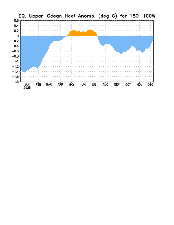
OHC has been rising sharply the last 30 days:
-
In the last 30 years at DCA there have been 12 below average Dec. In last 30 there have been four at -5 or colder:1995, 2000, 2005 2010. Notice how in blocks of five and perhaps again this year
-
Interesting stats! Obviously it has felt like the coldest start to winter in a number of years, but it's impressive that this prolonged snow cover is so rare for this early in the season. 2010-11 was quite a winter...
-
The car washes are gonna look like Walmart on black friday tomorrow.
-

Mid to long range discussion- 2025
WinstonSalemArlington replied to wncsnow's topic in Southeastern States
-
If we have a tanked PNA, that raises the likelihood the SE ridge will link up with any -NAO block which obviously is a disaster.
-
December 2025 regional war/obs/disco thread
weatherwiz replied to Torch Tiger's topic in New England
It's basically trying will things to happen which look bad. Trying to find ways in which it will work. 99% of forecast models could show a rain storm at D6 and one model showing potential for all snow...all the focus would be on how that one model "could verify" over what the actual situation is I mean...I'm not complaining about this, that's why we're all here and it's the purpose of the board...it's a discussion board lol. But it does I think yield in blending the line of fantasy versus reality at times. -
Great to have it during the lowest sun angle of the year too so we’re not losing much of it every day like in March.
-
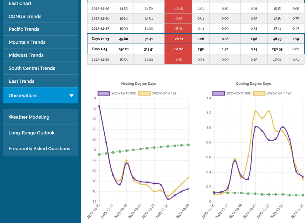
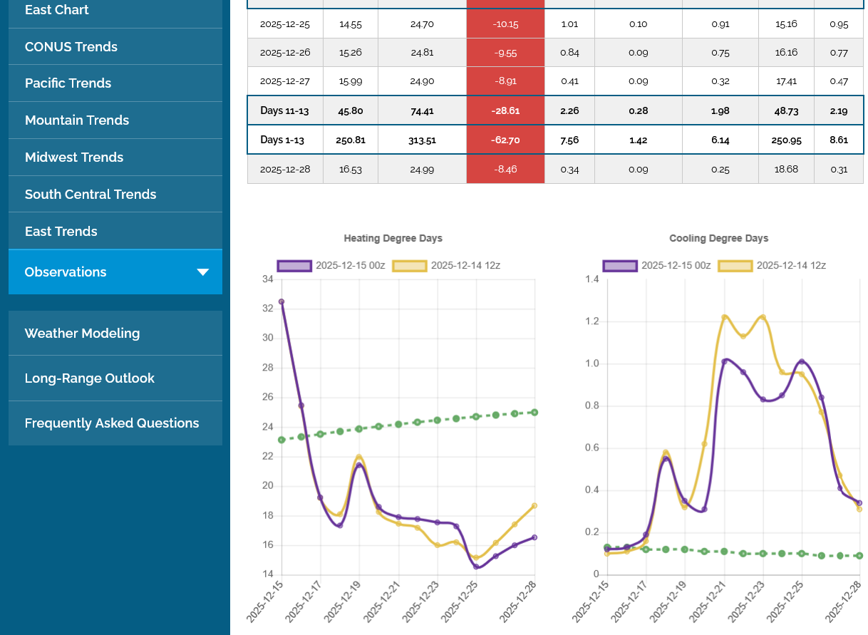
Yeah, unfortunately here’s the ugly truth for E US cold preferrers (NG is down another 1% today making it a whopping 26% drop from the peak 11 days ago): left graph has EPS HDD (latest out/0Z in purple); note the cliff dive it takes from today’s very cold 33 HDD, which is a whopping 10 above the normal of 23, to 12/18’s mild 18, which is 6 below the normal of 24! It later gets as low as 15 on 12/25, which is 10 below the normal of 25!