All Activity
- Past hour
-

July 2025 Discussion-OBS - seasonable summer variability
donsutherland1 replied to wdrag's topic in New York City Metro
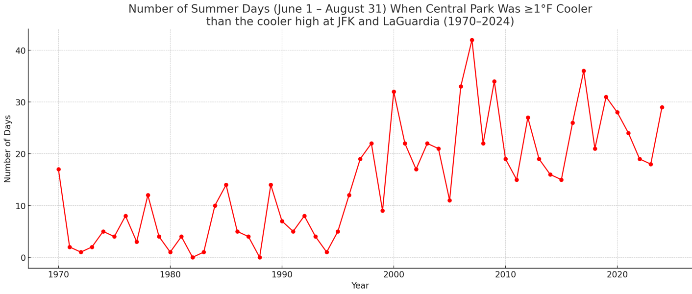
Another look at Central Park's summer temperature issue: During 1970-1995, there were 5.4 days per summer when Central Park's high temperature was 1° or more cooler than the cooler high at JFK Airport and LaGuardia Airport. During 1996-2024, that figure was 22.8 days. Since 2000, that figure has averaged 24.0 days. The change in those averages are even more dramatic for days when Central Park had a high temperature that was at least 2° cooler than the cooler high at JFK Airport or LaGuardia Airport: 1970-1995: 1.3 days per summer 1996-2024: 11.1 days per summer 2000-2024: 12.2 days per summer Not all of this change has to do with the trees, but most of it does. One has seen smaller changes in the same direction for January 1-March 31 and October 1-December 31. However, the summer change is biggest. Change in Days with Highs 1° or More Cooler than the Cooler High at JFK Airport and LaGuardia Airport: 1996-2000 vs. 1970-1995: January-March: +93%; June-August: +322%; October-December: +122% Change in Days with Highs 2° or More Cooler than the Cooler High at JFK Airport and LaGuardia Airport: 1996-2000 vs. 1970-1995: January-March: +59%; June-August: +754%; October-December: +135%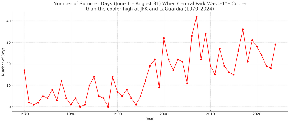
-
0z euro joined GGEM in bringing rain to the area Monday from TD3/Chantal. Euro gets rain to the 95 corridor while GGEM gets it back to the Blue Ridge.
-
Looks like it rebounded to a daily high of 93. Probably just a result of variable cloud cover.
-

July 2025 Discussion-OBS - seasonable summer variability
ForestHillWx replied to wdrag's topic in New York City Metro
Back to back morning lows of 57/58; very refreshing from the humidity of late. -

July 2025 Obs/Disco ... possible historic month for heat
Damage In Tolland replied to Typhoon Tip's topic in New England
Thankfully stayed in the 60’s at home . Avoided any terrible summer cool even if not there. -

July 2025 Obs/Disco ... possible historic month for heat
OceanStWx replied to Typhoon Tip's topic in New England
July morning of yore. -

July 2025 Discussion-OBS - seasonable summer variability
steve392 replied to wdrag's topic in New York City Metro
WOW, what an incredible morning coming to work. 60 degree's in Mahwah currently. -
Great temps this morning, but there is still visible smoke in the air from the festivities last night. Air quality is bad.
-

July 2025 Obs/Disco ... possible historic month for heat
dendrite replied to Typhoon Tip's topic in New England
Min 51.0° -
The WPAC SSTS up to this point are matching previous years that went on to see predominantly +WPO winters
-

July 2025 Obs/Disco ... possible historic month for heat
HoarfrostHubb replied to Typhoon Tip's topic in New England
Low of 51 here. Should add 30 degrees or so - Today
-

July 2025 Obs/Disco ... possible historic month for heat
ineedsnow replied to Typhoon Tip's topic in New England
49/49 -
July 2025 Obs/Disco ... possible historic month for heat
ineedsnow replied to Typhoon Tip's topic in New England
51/49 perfect out -
This is just terrible. The Guadalupe River rose at least 30 feet in a very short time in the middle of the night. https://apnews.com/article/thunderstorms-texas-deaths-camp-mystic-trees-hail-e8a4c85c77f714c9a974e50f3cd1fca1
-

July 2025 Discussion-OBS - seasonable summer variability
SACRUS replied to wdrag's topic in New York City Metro
-

July 2025 Obs/Disco ... possible historic month for heat
Snowedin replied to Typhoon Tip's topic in New England
Could care less about fireworks right now. We had enough of the natural stuff coming right from Thor himself yesterday to keep me satisfied for a few days. Now if only those damn kids would get off my lawn and quit ruining my piles of dried up doggy doo with their sparklers! -
July 2025 Discussion-OBS - seasonable summer variability
SACRUS replied to wdrag's topic in New York City Metro
Highs: EWR: 87 JFK: 87 ACY: 86 TEB: 85 PHL: 85 New Brnswck: 84 LGA: 84 BLM: 83 ISP: 83 NYC: 83 TTN: 82 -

E PA/NJ/DE Summer 2025 Obs/Discussion
RedSky replied to Hurricane Agnes's topic in Philadelphia Region
A depression rains would be depressing -

July 2025 Obs/Disco ... possible historic month for heat
DavisStraight replied to Typhoon Tip's topic in New England
We just blew some off at my friends, his Rotty sits right next to us and watched them without flinching. -
July 2025 Obs/Disco ... possible historic month for heat
DavisStraight replied to Typhoon Tip's topic in New England
60/56, great night for fireworks. -

July 2025 Obs/Disco ... possible historic month for heat
mreaves replied to Typhoon Tip's topic in New England
You’re pretty weak if you needed a sweatshirt today. -
BULLETIN Tropical Depression Three Advisory Number 2 NWS National Hurricane Center Miami FL AL032025 1100 PM EDT Fri Jul 04 2025 ...TROPICAL DEPRESSION FORECAST TO STRENGTHEN ON SATURDAY... SUMMARY OF 1100 PM EDT...0300 UTC...INFORMATION ----------------------------------------------- LOCATION...30.6N 78.9W ABOUT 165 MI...260 KM SSE OF CHARLESTON SOUTH CAROLINA ABOUT 255 MI...415 KM SSW OF WILMINGTON NORTH CAROLINA MAXIMUM SUSTAINED WINDS...35 MPH...55 KM/H PRESENT MOVEMENT...STATIONARY MINIMUM CENTRAL PRESSURE...1012 MB...29.89 INCHES Tropical Depression Three Discussion Number 2 NWS National Hurricane Center Miami FL AL032025 1100 PM EDT Fri Jul 04 2025 The depression is less organized on satellite imagery this evening, with a seemingly elongated low-level center near or just west of the deep convection. This structure is due to persistent southwesterly shear, with a mid-level circulation apparent east of the low-level center. The current intensity will remain 30 kt, consistent with data from the last Air Force reconnaissance mission and satellite trends. The system has been moving erratically recently, but a longer term motion is basically stationary. A slow north-northwestward motion is anticipated to begin on Saturday as the depression is steered on the northeast side of a developing mid- to upper-level low over the northeastern Gulf. After that time, the system should be steered to the north and northeast with a gradual increase in forward speed along the western periphery of the subtropical ridge. This motion should bring the center near or over the coast of South Carolina Sunday morning. The new NHC track forecast was nudged to the east, consistent with the latest guidance. The global models generally indicate that the current shear should lessen on Saturday, which could allow for some strengthening in combination with the warm waters of the Gulf Stream. There is plenty of dry air aloft, however, which will probably limit significant development, as well as the current disheveled structure. The bulk of the guidance indicates modest strengthening as the system approaches the coast, and the new forecast follows suit, near the latest model consensus. FORECAST POSITIONS AND MAX WINDS INIT 05/0300Z 30.6N 78.9W 30 KT 35 MPH 12H 05/1200Z 30.9N 79.1W 35 KT 40 MPH 24H 06/0000Z 31.7N 79.5W 40 KT 45 MPH 36H 06/1200Z 32.9N 79.8W 35 KT 40 MPH...INLAND 48H 07/0000Z 34.2N 79.6W 30 KT 35 MPH...POST-TROP/REMNT LOW 60H 07/1200Z 35.5N 78.5W 25 KT 30 MPH...POST-TROP/REMNT LOW 72H 08/0000Z...DISSIPATED $$ Forecaster Blake
-

July 2025 Obs/Disco ... possible historic month for heat
Torch Tiger replied to Typhoon Tip's topic in New England

-
July 2025 Obs/Disco ... possible historic month for heat
Torch Tiger replied to Typhoon Tip's topic in New England
Vis is 1 mi -
July 2025 Obs/Disco ... possible historic month for heat
Torch Tiger replied to Typhoon Tip's topic in New England
Nice smoke/haze. Lowell nasty;D