All Activity
- Past hour
-
High of 45.3°, lowest high of the season so far.
-
Today was better. A predicted high of 56 with a high of 55. The forecaster at Sterling needs to understand that with an approaching system, a warmfront in southwest Va. with CAD creates low values over N.W. Va.
-
What’s even wilder is there are some places in eastern N.C. that still haven’t hit freezing, and Florida got this cold
-
Lamar has an ankle injury now. After knee and hamstring. Dude is far from 100% clearly. Almost just say to rest this week against the Jets and let Snoop play and be ready for Thanksgiving.
-

Central PA Fall Discussions and Obs
Jns2183 replied to ChescoWx's topic in Upstate New York/Pennsylvania
Didn't places in the Dakotas go from 70's to feet of snow in 12 hours Sent from my SM-G970U1 using Tapatalk -
 Winter arriving in mid-December. As predictable as tides.
 -

Pittsburgh PA Fall 2025 Thread
Rd9108 replied to TheClimateChanger's topic in Upstate New York/Pennsylvania
Pattern looks to be shaping up for the coming weeks for below average temps. The risk for winter weather should increase. Just like the Pirates signing a notable free agent Ill believe it when it happens.
-
You don't see this that often so things can, and have, been worse.
-
As @WxUSAF said, we seem to be consistently trending cooler as we close on events.
-

November 2025 general discussions and probable topic derailings ...
CoastalWx replied to Typhoon Tip's topic in New England
Good for you. Get conditioned for heavy heavy hips n lips shoveling. -
Sadly, the trend today in models has been to dry it out for most of the area, with the precip focused further east. We'll get a little rain it appears, which is better than nothing, but still disappointing given the potential.
-

Mid to long range discussion- 2025
WinstonSalemArlington replied to wncsnow's topic in Southeastern States
We are so back! - Today
-
Interesting look.... FWIW. Something to maybe watch 10 days out...
-

December 2025 Short/Medium Range Forecast Thread
Carvers Gap replied to John1122's topic in Tennessee Valley
What is even wilder, a lot of higher elevation folks are already on the board. I am even on the board w/ 0.5" of snow already, and w/ a NW flow event to boot! -
December 2025 Short/Medium Range Forecast Thread
Carvers Gap replied to John1122's topic in Tennessee Valley
The mean doesn't have dump into Texas. In fact, it might have the trough too far to the East. Right now(and I know you know this...but this is for new folks), it is so tough to know the trough axis at this range - IDK at this point. Some modeling is just sending the cold straight to Texas. Some tends to send into the SE or NE and the MA. I would suggest the MJO is driving that along w/ the SSW. If that MJO stalls, we all will probably be just wanting it to warm-up. In my mind, I see a cold shot after Thanksgiving, a warm-up, another cold shot around the 3rd which means business....and the cold keeps on coming until about Christmas when the pattern moderates. The danger is that some modeling does not want to moderate after Christmas. There is a small camp of model runs which deepens the cold to enter January. In fact, seasonal cold is the warmest those runs get w/ well BN being the base pattern. Now, I hate even to mention that on a forum. If it doesn't happen, the disappointment is tough for some....and that hasn't happened since maybe 09-10 But it is worth noting. Those runs aren't quite outliers either. The MJO above would support some of those runs. The interesting thing is if the MJO were to loop back into the cold phases w/ no tour through the warm phases...we haven't seen that type of plot recently. Plus, there is the rare tour-de-warm MJO that never gets warm. This is IMHO is class -QBO territory in terms of analogs. -

Central PA Fall Discussions and Obs
Festus replied to ChescoWx's topic in Upstate New York/Pennsylvania
The Chinook is absolutely correct. The write up is as follows: "A downslope chinook wind event pushed the temperature at the town of Loma from -54°F at 9 am on January 14, 1972, to 49°F by 8 am on January 15th. The 103°F (57.2°C) rise is the greatest change in temperature ever officially measured on earth within a 24-hour period." Can you imagine? According to AI , the Lancaster daily range record is 57 degrees set on December 23, 2022. -
December 2025 Short/Medium Range Forecast Thread
Carvers Gap replied to John1122's topic in Tennessee Valley
Precip is AN on the mean and all over the place on the control. The control implies good precip for western areas of the forum(remember the boundary) and then again for coastal areas from Georgia to the MA late in December. E TN and W NC would be BN for precip if the control is correct. If the mean is correct, the entire forum is BN w/ temps and AN for precip. I think the cold is under modeled at this point - I didn't think that a few days ago and my mind can change on that again. If it is, the storm track is along the spine of the Apps. -

December 2025 Short/Medium Range Forecast Thread
Daniel Boone replied to John1122's topic in Tennessee Valley
I always hated to see a Trough dig deep into the SW. Without blocking that generally pumps the SER. With blocking you can get overunning or Waves eject Eastward that pay dividend's. However, with a -EPO you can sometimes get cold highs drop down east of that SW trough and get cold but, usually dry. The above Depictions Carver posted are showing good progression. Somewhat of a SER can be good for our Area as Carvers noted. Waves ride along that Boundary. Just my Antique 2 Cents worth. -
December 2025 Short/Medium Range Forecast Thread
Carvers Gap replied to John1122's topic in Tennessee Valley
For now(and famous last words as we have been fooled many times over the years by December cold on modeling which didn't verify in reality), there is a decent signal for a cold December. Will it be stormy? Well, we honestly maybe don't want the severity of cold shown, but the opportunity for NW flow events and for Gulf systems to attack the base of the trough are probably embedded in a pattern like that. -
.
-
Snowmap looks great for the east.
-
December 2025 Short/Medium Range Forecast Thread
Carvers Gap replied to John1122's topic in Tennessee Valley
Here is the Euro Weeklies 30 day map centered on December(the above is Dec3-Jan4). This one is Dec1-Dec31. I have also included the CFSv2 which ran at lunch. Where that EPO ridge sets up in the eastern Pac is important. HL blocking near Greenland is not as important in December as it is in Jan/Feb. But it would only accentuate potential for cold. As John noted, the real risk is cold/dry. The good thing is that models are showing some AN heights over FL. That would imply that rain/snow would run a path from say TX/LA to DC. Storm tracks could be the Ohio Valley if the pattern relaxes or the Piedmont if the cold presses. edit: the slight area of an heights over the Gulf states is not a bad thing. Overall, temps in our area are seasonable BN. The storm track will likely ride that boundary. I suspect(if the mean is correct), MUCH colder temps would head southward. That EPO ridge is nearly perfect for sever cold outbreaks. -
 He said he’s never interacting with you again on here
 -
Central PA Fall Discussions and Obs
Jns2183 replied to ChescoWx's topic in Upstate New York/Pennsylvania
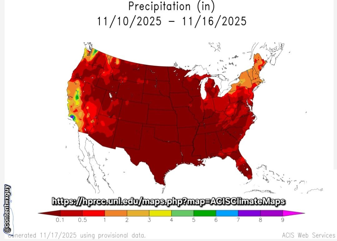
I believe last week we were discussing the lack of beneficial rain. My fear for this winter is us turning into a cold desert. Sent from my SM-G970U1 using Tapatalk
-
December 2025 Short/Medium Range Forecast Thread
Carvers Gap replied to John1122's topic in Tennessee Valley
I have like the Euro control of the weeklies. Meaning that if the ensemble and the control don't match, that is a problem as the control is often right. It spotted the push back on the colder temps for early December. It wasn't completely right, but there was a warm front embedded that the ensemble didn't see. This is this afternoons December map. I don't use these maps verbatim, but just to get a general sense of what is on the table if the 0z Euro was run past 16 days and all the way to Jan 4th! The ensemble shows this general depiction but MUCH more washed out - seasonably cold. It is also important to remember that seasonal cold at range...is probably colder in reality. -15F departures (relative to norms) is insane for a 30 day map. edit: To me, that is showing signs of the stratospheric warming as the latter part of that run is brutally cold in the lee of the Canadian Rockies. We see that often w/ strat warms. Cold dumps west and spreads east. The last week of this run is almost 40 BN in the Rockies. Notice those aren't reflected strongly on this map...it had to eras some warm departures in those places.