All Activity
- Past hour
-
28.0. First hard freeze. She’s dead, Jim
-

Central PA Fall Discussions and Obs
Mount Joy Snowman replied to ChescoWx's topic in Upstate New York/Pennsylvania
Low of 37. Quite the blustery day on tap for tomorrow. @Itstrainingtime still haven’t forgotten about your Grunk inquiry, just been super busy. At this point I think I’ll just take in today’s game before commenting ha. I do know this, it’s been nothing but heartbreak hotel for this team lately. They really deserve to have something good happen to them here down the stretch. -
you forgot the "PREPARE NOW"
-
that's a LOT better than i'd expect
-
Yes, nothing awful about MJO phase 6 in December so of course phase 7 would be even better. Phase 6, La Nina DEC
-

November 2025 general discussions and probable topic derailings ...
rimetree replied to Typhoon Tip's topic in New England
25.0 this morning...coldest so far. Not sure this winter will be much better than the last several but I do like that we've only been above 60F (61) once so far this month whereas last year we did that six times in the first half. Three of those were above 70F. Maybe a good sign? -
CFS Winter
-

Occasional Thoughts on Climate Change
donsutherland1 replied to donsutherland1's topic in Climate Change
Low-cost labor is only a part of China's advantage in renewables. It probably helped initiate things, but China's advantage now goes far beyond labor costs. The combination of its comparative advantage in access to rare earth minerals, experience/learning benefits from aggressively advancing its renewable energy technologies, and economies of scale from its scaling production have given it a significant and sustainable competitive advantage. It's difficult to envision any other country being able to imitate what China is able to do in producing renewable energy technologies anytime soon. Moreover, China is beginning to deploy AI in its renewable energy technology development, which could give it another boost in its renewable energy leadership. In contrast, the U.S. has largely ceded this field. Moreover, its doubling down on energy of the past and its suppression of scientific research through policy/funding changes could essentially deprive it of a capacity to become competitive in renewable energy technology. -
 Only down to 29.8° this morning. No fake cold for me.
 -
Iowa at USC, 3:30pm EST, could be a fun watch.
-

E PA/NJ/DE Autumn 2025 Obs/Discussion
Albedoman replied to PhiEaglesfan712's topic in Philadelphia Region
the big pattern change is afoot- 4 corners lows constantly ejecting toward us for the next 3-4 weeks. One of them should be a minimal car topper event but still the GOM is not opened for business yet. We really need one of the 4 corner lows to go into the GOM and then run up the coast and stall as a Miller A. The PAC winds are just to strong right now and too progressive. Three more days of 40+ winds coming this week. I am so tired of dealing with dead ash trees falling with our public works dept. -

E PA/NJ/DE Autumn 2025 Obs/Discussion
LVblizzard replied to PhiEaglesfan712's topic in Philadelphia Region
A lot of the hi-res models have lake effect streamers making their way across PA tomorrow evening. Some of us could get a localized snow squall that whitens the ground. -

Central PA Fall Discussions and Obs
canderson replied to ChescoWx's topic in Upstate New York/Pennsylvania
Sunday is going to be rough. Advisory snow from lake bands in the north. Advisory level wind everywhere. White outs as far as as 81. And some gusts north of 55 mph. Pattern turns blustery behind the cold front late Saturday night through Sunday. Wind gusts 30-40+ mph are definitely in the cards with potential for advisory criteria. The increasingly strong west-northwest flow will develop across the Great Lakes and open up the potential for lake effect/upslope snow into the interior of CPA Sunday afternoon through Sunday night. Specifically, a multi-lake connected snowband or bands is trending more likely to probable based on the latest higher res model guidance extending from Lake Superior/Huron across Erie into northwest PA. Probabilities are at least 50/50 for advisory level snow accum especially in more persistent NW flow trajectory bands. There may also be an emerging signal for some squalls or very long fetch bands perhaps extending as far southeast as the I-81 corridor. We were keen to message the multitude of potential hazardous weather concerns over the weekend in ranked order of confidence (high to low): -strong (non-tstm) wind gusts >40mph -lake effect snow accumulation north of I-80 & west of US-219 -heavy snow bands or squalls -strong thunderstorm wind gusts >50 mph -
 oak Armageddon
 -

November 2025 general discussions and probable topic derailings ...
CoastalWx replied to Typhoon Tip's topic in New England
Inches of leaves on my yard. It’s like a KU of leaves. -
From the latest ENSO PPT (backloaded winter vibes?)... La Niña conditions are present.* Equatorial sea surface temperatures (SSTs) are below average across the central and east-central Pacific Ocean. Atmospheric anomalies over the tropical Pacific Ocean are consistent with La Niña. La Niña conditions are present and favored to persist through December 2025 - February 2026, with a transition to ENSO-neutral likely in January-March 2026 (55% chance).*
-
 One and ONLY leaf cleanup after lunch today. Temps climbing nicely after a low of 27.
 -
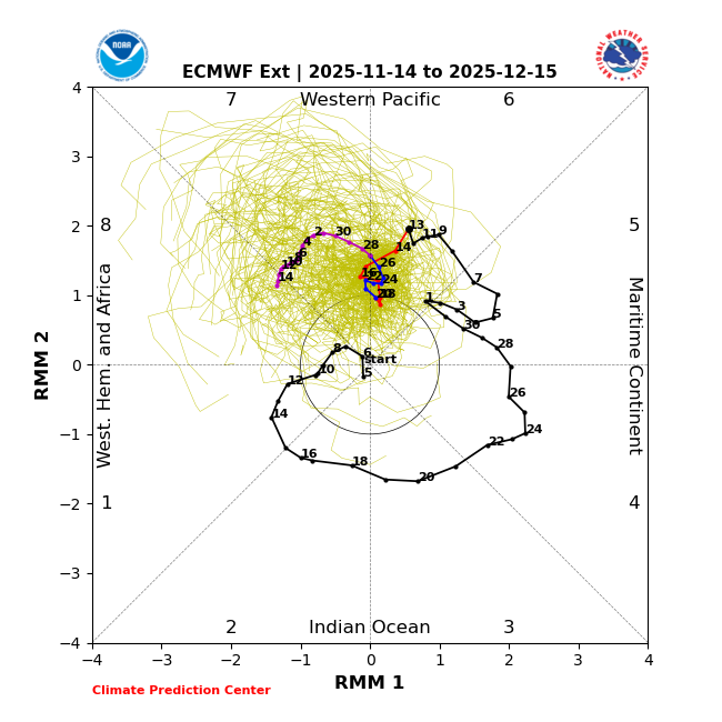
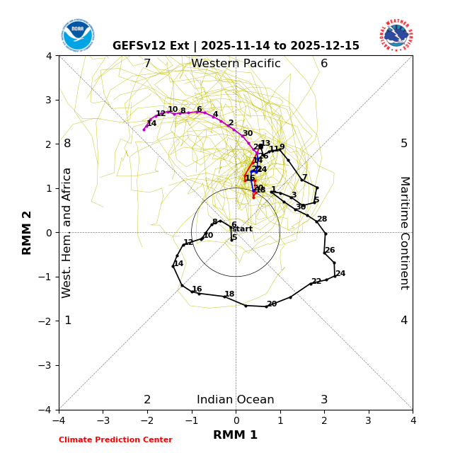
Latest EPS and GEFS extended MJO both head into Phase 7 by the end of the month after a long stall in warm Phase 6. Question: DT states 7 is still a warm phase in December while JB says 7 is ok in December. Anyone have data on this topic. If 7 is still warm we will wait until mid December for Phase 8.
-
November 2025 general discussions and probable topic derailings ...
CoastalWx replied to Typhoon Tip's topic in New England
They just showed this pic on Fox 25. You fooking weenie. -
Sounds like a cartopper, at least.
-
2025-2026 ENSO
donsutherland1 replied to 40/70 Benchmark's topic in Weather Forecasting and Discussion
Social media version of the ECMWF weekly forecast for December 1-8: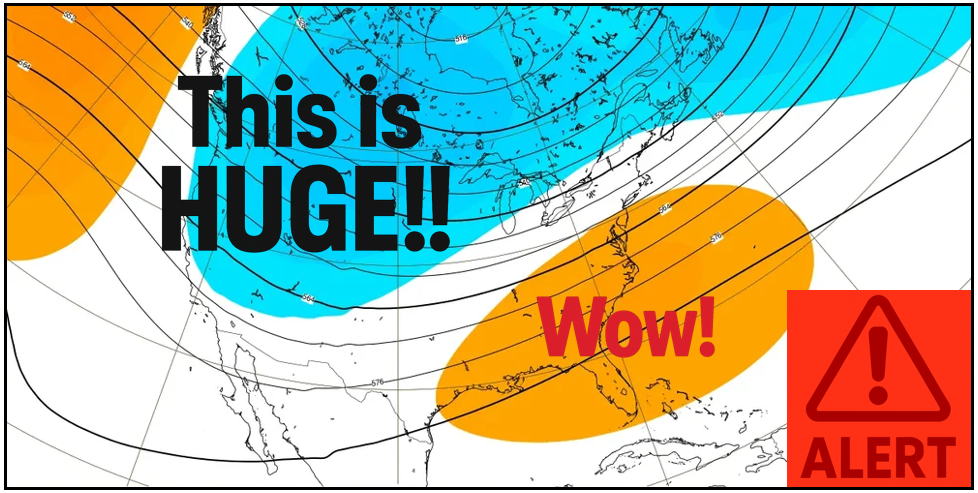
-
I had 30 seconds of heavy rain.
-
The slowdown has happened a few times in the past as it got closer. Sometimes models are too gungho in the long range just to tame it back.
-
It’s certainly possible that it goes into phase 8 in December. However, the earlier idea that it would propagate into phase 8 by the end of this month appears to be dead in the water right now. The progression has slowed considerably
-
Cloudy for 2 days, then a broken line of showers, and then partly sunny and windy for 2 days followed by 1.5 days of nice weather...rinse, repeat. If this is the base state satellite imagery this winter...then we're staring down the barrel of another steroidal La Nina pattern... https://www.star.nesdis.noaa.gov/GOES/conus_band.php?sat=G19&band=GEOCOLOR&length=24


