All Activity
- Past hour
-

Jan 24-26 Weekend Snow and Sleetfest Model Thread Part Tres
pazzo83 replied to H2O's topic in Mid Atlantic
17/-9 -
Big Rapids is already down to -20 at midnight. MBY is -15 with 8 more hours of darkness. Only high clouds could screw it up.
-

Jan 24-26 Weekend Snow and Sleetfest Model Thread Part Tres
NorthArlington101 replied to H2O's topic in Mid Atlantic
I think it struggles to mix out the sleet…. But more wintry precip all the same -

Jan 24-26 Weekend Snow and Sleetfest Model Thread Part Tres
bncho replied to H2O's topic in Mid Atlantic
About the Euro... I can say that it is wetter than 18z for most areas. I do not know about the thermals. -
Jan 24-26 Weekend Snow and Sleetfest Model Thread Part Tres
bncho replied to H2O's topic in Mid Atlantic
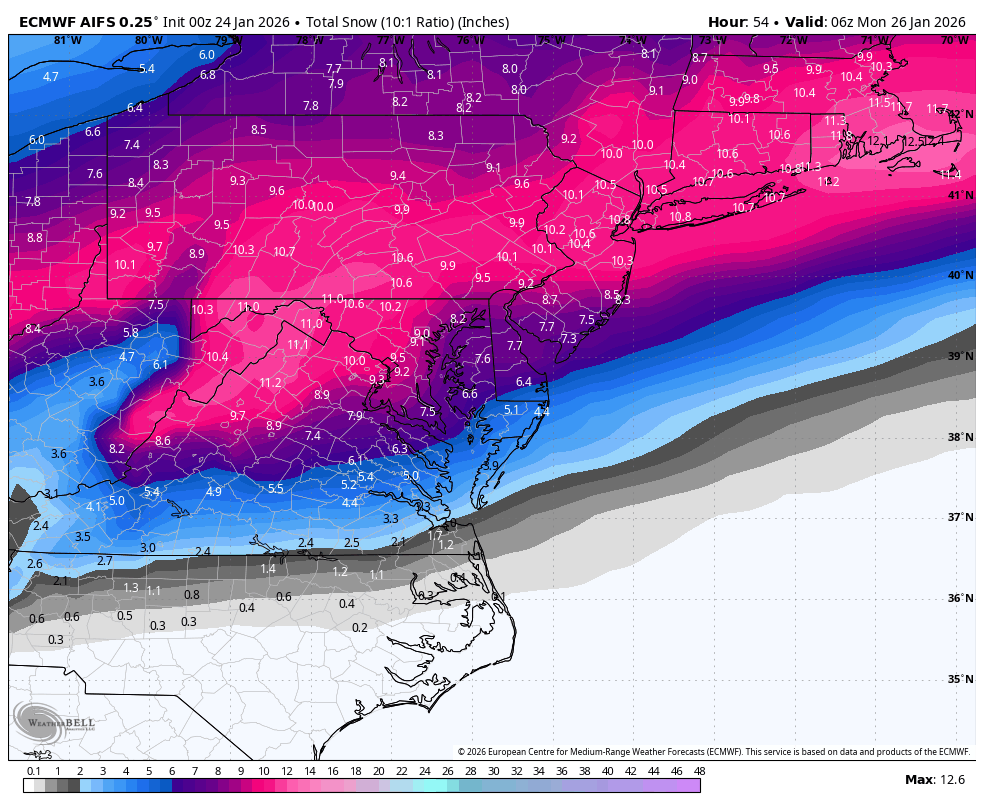
That's probably like 12" of snow in DC with the ratios -
Jan 24-26 Weekend Snow and Sleetfest Model Thread Part Tres
NorthArlington101 replied to H2O's topic in Mid Atlantic
AIFS (probably out of its best range) got a bit wetter.
-

Jan 24-26 Weekend Snow and Sleetfest Model Thread Part Tres
MillvilleWx replied to H2O's topic in Mid Atlantic
I’ll say this for the northwest crew, the models are really good out this way with these ratios. 18-20:1 is a good bet for the first 4-6 hrs of the storm before they slowly scale back, but even still, it’s probably 15:1 or better through 15z Sunday. After that, it’ll be a degrading column with the warm nose trying to approach, but flakes will be massive. Clumped aggregates that’ll still amount to 10-12:1 before a flip of any kind. -

Jan 24-26 Weekend Snow and Sleetfest Model Thread Part Tres
caviman2201 replied to H2O's topic in Mid Atlantic
https://x.com/RyanMaue/status/2014921199768240324?s=20 Maue is very big on the RRFS built-in ratio model which looks better than Kuchera for here Kuchera: RRFS Ratio: -

“Cory’s in LA! Let’s MECS!” Jan. 24-26 Disco
WxWatcher007 replied to TheSnowman's topic in New England
I'm just ready for it to get here. At some point, enough is enough. Of course, I'm up for the euro and tracking temps. -
Euro and GFS are nearly worthless right now… HRRR and NAM are what we should be paying attention to. Snow line is much more to the south than the NAM and HRRR have it .
-
It does seem all the models have went south about 2 counties. The front end thump of snow has also increased for Nashville proper. The worse of the ice for TN seems th bullseye is straight into Nashville. The GFS is not going down alone. Will the Euro jump on board with the GFS & other models?
-
No explosions yet but the night is young. -10.0/-16. Since this isn't a radiational cooling night I've been tracking close to KSLK. They're -11. Wind chill -28.
-

“Cory’s in LA! Let’s MECS!” Jan. 24-26 Disco
RUNNAWAYICEBERG replied to TheSnowman's topic in New England
UK is weak over here. Ema thieves… -
Jan 24-26 Weekend Snow and Sleetfest Model Thread Part Tres
bncho replied to H2O's topic in Mid Atlantic
Euro running -

Jan 24-26 Weekend Snow and Sleetfest Model Thread Part Tres
nj2va replied to H2O's topic in Mid Atlantic
If that carries eastward, it would remove the lone model that’s really punching the mid level warmth way quicker/north than others. I know I’ll flip but a few extra hours will make a big difference. -
Jan 24-26 Weekend Snow and Sleetfest Model Thread Part Tres
MillvilleWx replied to H2O's topic in Mid Atlantic
20/3 at my place currently 11/-7 where I’ll be for the storm This Arctic shot is no joke -

“Cory’s in LA! Let’s MECS!” Jan. 24-26 Disco
TauntonBlizzard2013 replied to TheSnowman's topic in New England
Definitely good to see the coastal assist creeping back into the picture tonight. That will be critical to follow tomorrow. Like I said earlier, probably the difference between 10-15 and 15-20 -

Pittsburgh/Western PA WINTER ‘25/‘26
SteelCity87 replied to Burghblizz's topic in Upstate New York/Pennsylvania
I've gotten very good at tempering expectations between snow and sports. I've been telling myself to expect 8-12" but I'll go with 12 imby -

Jan 24-26 Weekend Snow and Sleetfest Model Thread Part Tres
LVblizzard replied to H2O's topic in Mid Atlantic
That too…reflectivity is bright and CC shows a clear boundary from roughly Ada to McAlester. Still means the NAM was too warm which has me injecting some hopium. -
 Yeah, well, Scottie, this has always been the case. It has more visibility now than it used to....for every blizzard of 93 where it was forecast 5 days out to the March 2001 debacle in the northeast....such is living as a meteorologist. I burnt out on this stuff a while ago but I still enjoy watching the lead in. Most meteorologists add massive value to people's lives but only get called out when it goes wrong. Until they make a computer that can intake data from every point on the globe at every altitude all at once then model it, things won't change (i.e. won't happen in our life time) ...and if it does eventually happen, then it will be boring....
 -

Jan 24-26 Weekend Snow and Sleetfest Model Thread Part Tres
jayyy replied to H2O's topic in Mid Atlantic
12z Mesos tomorrow will be super interesting. Watch the RAP show 13” again -

Winter 2025-26 Medium/Long Range Discussion
frostfern replied to michsnowfreak's topic in Lakes/Ohio Valley
So you would be happy with 3 one inch dusters in December followed by two months of arctic CAD and maybe a duster or two to offset sublimation? Just keep a steady 3 inches with zero melting. Stay below 15F so no melting on roads or dirty looking snow. -

Jan 24-26 Weekend Snow and Sleetfest Model Thread Part Tres
EHoffman replied to H2O's topic in Mid Atlantic
I mean you can just take a look at the radar and it's obvious that's sleet falling all through southern OK. -

“Cory’s in LA! Let’s MECS!” Jan. 24-26 Disco
78Blizzard replied to TheSnowman's topic in New England
Yup. -

Jan 24-26 Weekend Snow and Sleetfest Model Thread Part Tres
HighStakes replied to H2O's topic in Mid Atlantic
9.