All Activity
- Past hour
-
Hard to think the cold up north will retreat that fast, but it's probably representative of a furthest north ensemble members.
-

Pittsburgh/Western PA WINTER ‘25/‘26
Rd9108 replied to Burghblizz's topic in Upstate New York/Pennsylvania
Cautiously optimistic about the next big chance. Its Ops vs AI models right now. Still a lot of time and details to hammer out -
Refreshing -8 outside. Lots of drifting overnight.
-
Correct me if I’m wrong, but the suppressed look on the GFS is less to do with anomalous strength of that high (it doesn’t seem that terribly strong) and more to do with the energy not ejecting from around the Baja. Definitely take your point regarding how the AI models may not “want” to reflect the more extreme potential in the atmosphere, though.
-

January 2026 regional war/obs/disco thread
George001 replied to Baroclinic Zone's topic in New England
Even non AI guidance has moved north. It’s still a whiff, but I like where we sit for this one. Btw how much snow did you end up getting? -

Rise of the Machines: January 18-19 Winter Storm Obs Thread
Damage In Tolland replied to WxWatcher007's topic in New England
Deep deep winter https://imgur.com/a/1IisTgl#uYRexFn https://imgur.com/a/1IisTgl#f4JBPIg -
What sucks: most AI guidance being an ice storm What doesn’t suck: Google DeepMind (#1 model), says WNC gets Dec 2018 redo
-
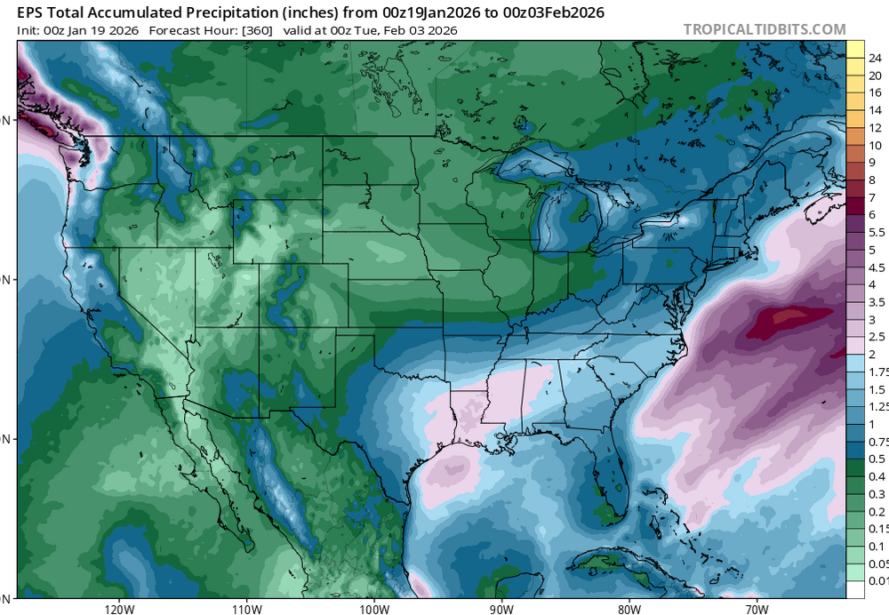
Both of these maps accurately depicts Chattanooga 95% of the time when there is a good snow in Tennessee. Not complaining, just stating facts. We have to have 100% perfect conditions for a good snow here. Sent from my SM-S916U using Tapatalk
-
I started at 7 years old.
-
Serious storm potential and we're only 5-6 days out!
-
I don't think it was meant for them to be successful, unless he's thinking his drought continues.
-
January 2026 regional war/obs/disco thread
Typhoon Tip replied to Baroclinic Zone's topic in New England
the differences are really easy to detect in the mid range. the AI versions have less cold exertion (less deep layer total mechanics therein), such that a vague S/stream wash runs up farther N as a wave/series/overrunning around the 25th. the standard versions preclude that from taking place because as they depict, an overbearing polar-arctic branch jams a confluence to an usually deep latitude across the conus ... utterly suppressive. Which is right? the AIs would get cold but seasonally so, then a durational ( which is hard to do in a fast footprint but given the flow orientation, about the only way to do it is this shallow azimuth rise coming E) multi regional winter event. the standard versions would plummet the NP/Lakes, with an somewhat attenuated eventual arrival here, but dry. -
If everyone (a reminder to myself as well) could try and put your posts in the context of a location that will help make the discussion clearer. What is good for southern VA is not necessarily good for northern GA
-

January 2026 Medium/Long Range Discussion
NorthArlington101 replied to snowfan's topic in Mid Atlantic
It’s on WxBell - don’t know if it’s available unpaid anywhere. This is prob the “money” frame but 850s are toasted. Surface is more than cold, though. -
January 2026 regional war/obs/disco thread
Go Kart Mozart replied to Baroclinic Zone's topic in New England
Apparently, there are some mets here who are having trouble letting go of the buggy whip models. -
Why congratulate 5 days before a Storm?
-
This is the most nerve racking part of the hobby, we’re at that day 6 range with a potential MECS in the cards. Been years since we had a potential event like this. Here, we, go .
-
It's on WxBELL.
-
Winter 2025-26 Medium/Long Range Discussion
A-L-E-K replied to michsnowfreak's topic in Lakes/Ohio Valley
p rough, most of the qpf over n il is the mid week duster so things about to get extra north dakota mode later this week -

Rise of the Machines: January 18-19 Winter Storm Obs Thread
moneypitmike replied to WxWatcher007's topic in New England
2.5 and still snowing at pit2 -
Where do we get it, if you have a link? Ty
-
Speaking through a NC lens mostly: I think at this point I feel pretty confident in verifying some sort of winter storm across the region this weekend but man are the red flags apparent. AI models have been outperforming the globals and to no surprise (or with our luck), of course they’re north with the coldest air and snow as the warm nose rages during the event. I’m not sold on that being the final solution, but if we get into tonight/tomorrow morning and it’s looking the same, we might be screwed. The AI models have been very locked in from day 4/5 on this winter. They have struggled a bit with a warm bias but generally, they nail the footprint in the medium-short range. I still think at worst, this is a sleet fest for most of the state. Last thought: for someone this will be an ice storm for the ages. Idc if the HP is over upstate NY, Ottawa, Iowa, whatever. It’s going to be somewhere in a favorable position and it’s going to be strong. This favors an abnormally large area of mixed precip and stupidly low temps being fed by a steady pump of cold, dry air. Remember, freezing rain is self limited if the cad is in-situ, but not when it’s an anchored HP to the north. Latent heat release can’t compete with that much caa. We’re talking nightmare type of stuff. Sometimes it helps if the precip is heavy, but in the mid 20s, that won’t matter either.
-
Gonna be a long week, ain’t it? 13F
-
This is what I’m worried about Buckeye. EPS and Canadian Emsembles are really hinting at this being a very good possibility with the American on an island that pushes the ridge out yielding colder upper levels. I would prefer no precipitation if a crippling ice storm were to hit large portions of the Carolinas.
-

Storm potential January 17th-18th
CPcantmeasuresnow replied to WeatherGeek2025's topic in New York City Metro
It's the same old story.


