All Activity
- Past hour
-

February 2026 Medium/ Long Range Discussion: Buckle Up!
mitchnick replied to Weather Will's topic in Mid Atlantic
?.thumb.png.2acbe2255d937b1ab021c2e073ad3514.png)
-

February 2026 Medium/ Long Range Discussion: Buckle Up!
GreyHat replied to Weather Will's topic in Mid Atlantic
6z ICON says OTS -
The tuesday/wednesday shortwave: Hmm.
-
Flurries 12⁰
-

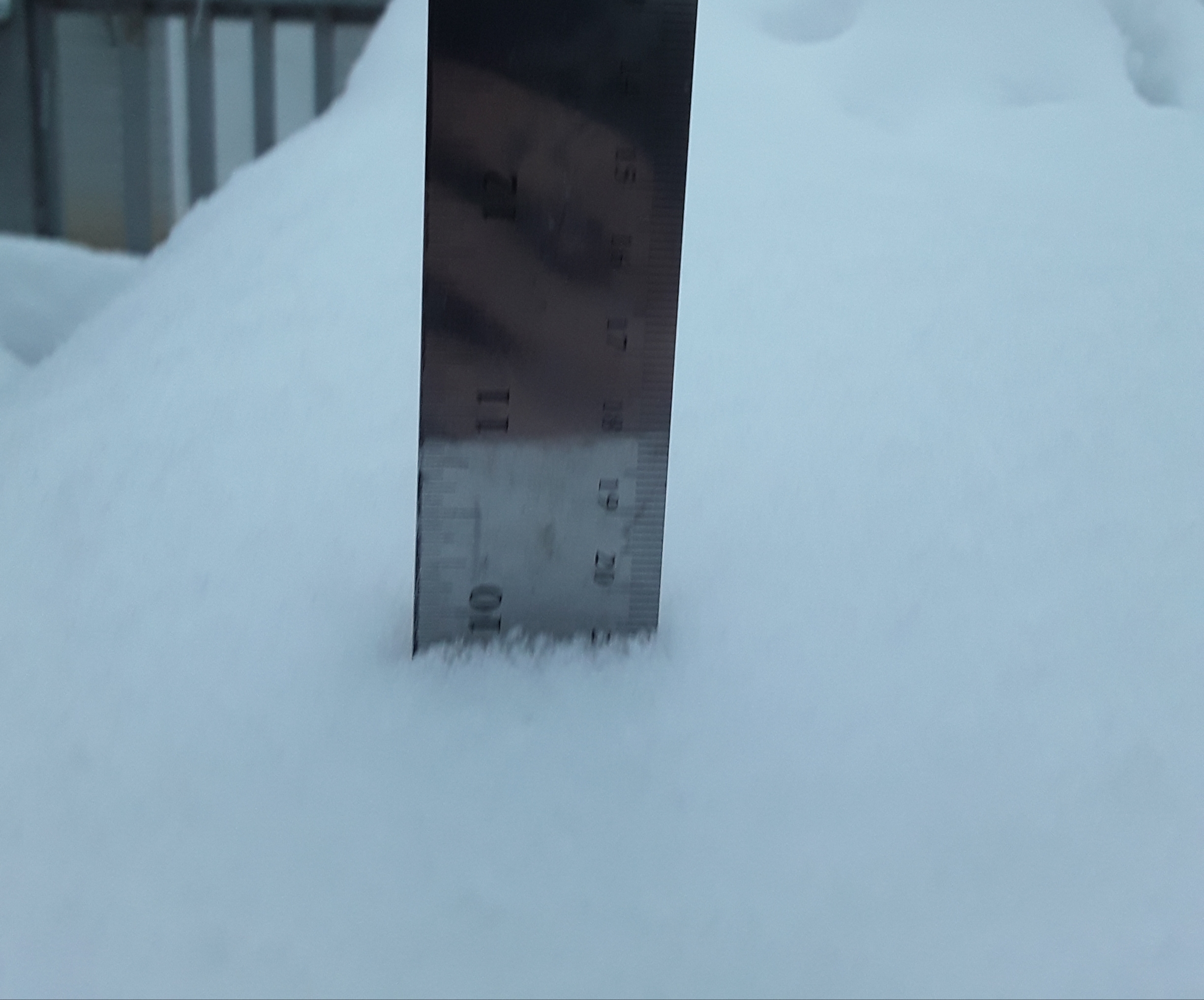
Central PA Winter 25/26 Discussion and Obs
Voyager replied to MAG5035's topic in Upstate New York/Pennsylvania
Recorded two of my higher gusts ever overnight. 18.6 mph last night, and 19.1 mph so far this morning. -
My Compact Total in PDII was 20”. 22” Total. Frustrating we didn’t hit 24. But the Piles were that of a Classic. And it a DC to Boston Bomb. NOT TO MENTION my Favorite Storm Ever, 2/7/03 of 14” was Mostly still there before the 22” of PDII came on top, AND all on Top of the 2” of concrete from the failed 12/25/02 storm that at least gave a historic base to a historically cold winter. 2002-2003 may have only had 84”, but it was a Great a winter as you could ever pray for. Better than the 120” 2004-2005 season that kept melting. My Compact Total in this was 13”. 18” Total. The photos I’m getting from Cumberland are Pretty good. But Certainly Not that Historic look of the Blizzard of 1996, AFD 1997, PDII, Blizzard of 2005, end of January 2011, Blizzard of 2013, or of Blizzard 2015. Sorry…. No Comparison.
-
12 degrees with flurries
-

Jan 30th-February 1st 2026 Arctic Blast/ULL Snow OBS Thread.
BlunderStorm replied to John1122's topic in Tennessee Valley
On the way home earlier this evening the shield of snow finally relented around 7:30. Roads were with little exception entirely white but kept traversable. Fortunately though, I didn't witness any crashes or spinouts. When I got back and went to measure snow depth was very variable anywhere from 5-9" with a mean around 6.5". Later after 10 snow showers returned and added a bit more atop. For the sake of records I will mark it as 7" although this is one of the shakiest all snow measurements I've done. As far as my memory serves this felt like the most impressive winter storm I've seen since maybe 2015. 8F and completely calm. Flurries falling. - Today
-

February 2026 Medium/ Long Range Discussion: Buckle Up!
nw baltimore wx replied to Weather Will's topic in Mid Atlantic
6z kind of nam’d us for Wednesday. -

February 2026 Medium/ Long Range Discussion: Buckle Up!
Ji replied to Weather Will's topic in Mid Atlantic
I hope the 6z Nam is right -

January 30th- Feb 1st ULL and coastal storm obs
donsutherland1 replied to JoshM's topic in Southeastern States
Charlotte picked up 11.0” of snow yesterday. That tied December 29, 1880 for the fourth highest daily figure on record. -

Richmond Metro/Hampton Roads Area Discussion
overcautionisbad replied to RIC Airport's topic in Mid Atlantic
Welp, got a feeling that's gg for Richmond this winter. Another winter with no major snow. Oh well. Not one flake today in Chesterfield. Just cold and very windy -

The “I bring the mojo” Jan 30-Feb 1 potential winter storm
Coach McGuirk replied to lilj4425's topic in Southeastern States
10. -
 Took this around 6 pm. Ended up with close to 11 inches here in Cornelius. She's a beaut, Clark!
-
The “I bring the mojo” Jan 30-Feb 1 potential winter storm
Coach McGuirk replied to lilj4425's topic in Southeastern States
I wish this thing would bomb out, NC stole my snow. Forecast was 5-8 inches and I have maybe an inch. -

The “I bring the mojo” Jan 30-Feb 1 potential winter storm
Roger Smith replied to lilj4425's topic in Southeastern States
2-3 hours more snow in eastern NC as 500 mb low is still back around SC coast and slowly catching up to the surface storm out in the ocean. The precip will likely become much lighter once the 500 mb low has passed to the east of given locations, but it won't necessarily end entirely right away. -
 Yeah bro...gonna be interesting to say the least...onslow...craven...Jones and Carteret co....woooo
 -
The “I bring the mojo” Jan 30-Feb 1 potential winter storm
Coach McGuirk replied to lilj4425's topic in Southeastern States
The slowest coastal low I have ever seen. We are talking 2 feet of snow in North Carolina. -
Brunswick co...Pender co..Onslow co...Carteret co and craven co...holy hell right now
-
Man...that low is taking its sweet time. Wilmington area getting in on it now. Central nc already has to have totals of like 20 inches??? Or more?
-
‘13-‘14 taught me that I have a limit with enjoying winter. Something I never would have thought possible up to that point. I “burnt out” after that season. Coincidently moved to Texas in early ‘14 summer. Not because of the weather, but certainly didn’t miss MW/GL winter the couple years I was there.
-
Ok smarty....still way less than what I want!!! Lol
-

The “I bring the mojo” Jan 30-Feb 1 potential winter storm
lilj4425 replied to lilj4425's topic in Southeastern States
That’s terrible. To the cliff diving thread. -
Damn it's still ripping in south wake!
-
Couple of weeks ago I was seeing maps that said AA temps for Feb. Shocker.
.png.e0db76434af62b073e40c73b247125c6.png)