All Activity
- Past hour
-
My comment was where Steve is and nothing to do with here. I’ve been saying for days this is not for me. Scooter knows, especially for his locale.
-

Nov 28-30th Post Turkey Day Wintry Potential
IWXwx replied to Chicago Storm's topic in Lakes/Ohio Valley
@Jackstraw Euro is doin' its thing to us.
-
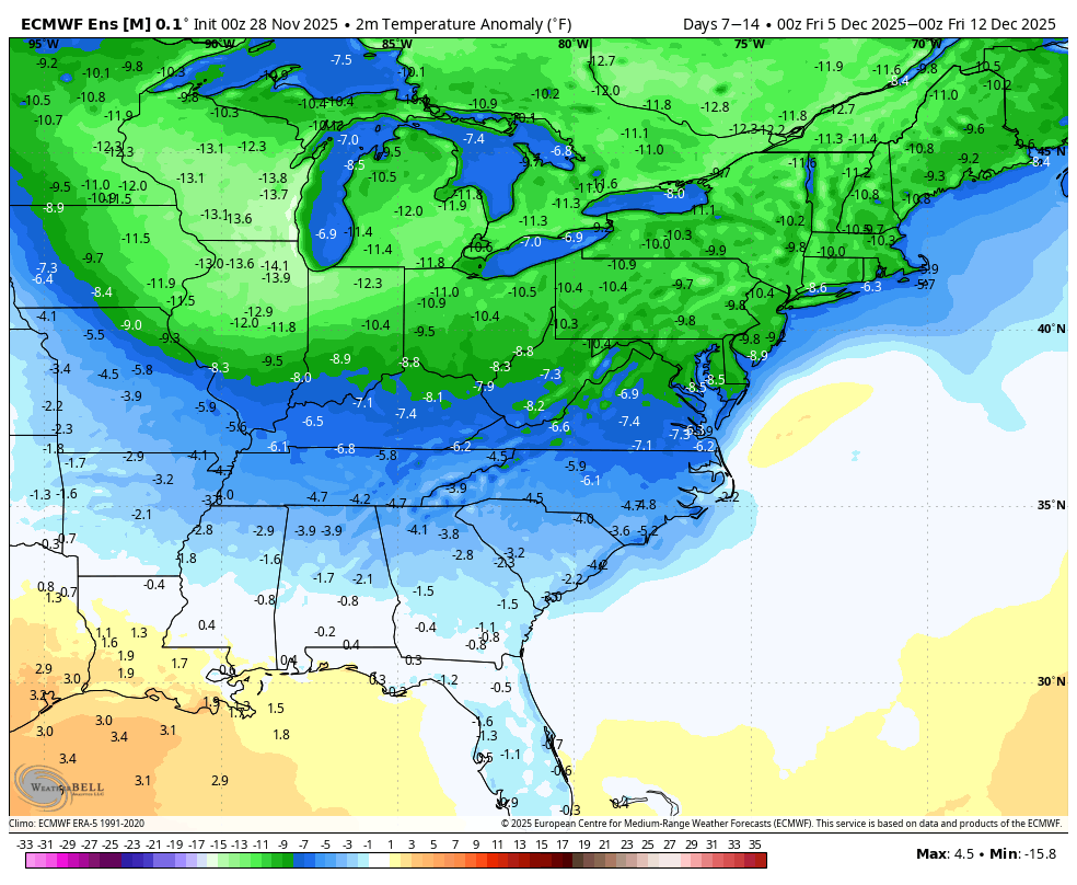
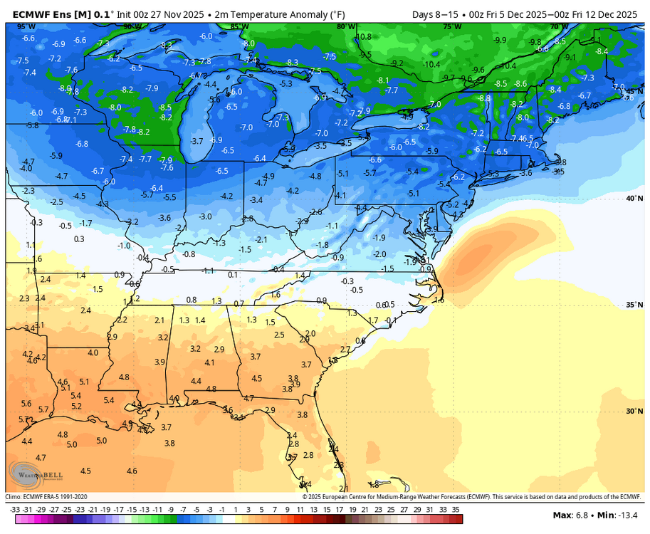
With the unfavorable changes in the MJO and AO/NAO, today’s 0Z GEFS is not surprisingly significantly warmer than yesterday’s run for the 2nd week in Dec. However, today’s 0Z EPS, which maintained its very long phase 8, is much colder than yesterday as well as the GEFS Yesterday’s 0Z EPS for 12/5-11 2m temps: Today’s 0Z EPS for 12/5-11: it’s pretty rare for a 7 day period of the EPS to have that much of a change within just 24 hours:

-

Nov 28-30th Post Turkey Day Wintry Potential
CheeselandSkies replied to Chicago Storm's topic in Lakes/Ohio Valley
I think you have to go all the way back to 2009 for the last true big dog (double digit totals) prior to December 10th in my memory. That one surely had some compaction involved, because it was low-ratio library paste, yet still flirted with or exceeded a foot in most parts of southern Wisconsin. -
Nice snow showers out here today. 35 degrees. Feels like a perfect winter day.
-
This is the kind of storm that I can imagine looking borderline for snow right down to the Bronx until the NAM sends the vortmax to Buffalo and torches 900mb to 8C... signaling the rest of guidance to rain to Albany. That said, synoptically, right now as modeled, it's pretty close for snow even in the City itself. The ICON and GFS have shifted slightly colder/south at 12z and 6z respectively, and ensembles (if you believe they are useful at this range) are south of their parent operational runs. The antecedent cold is marginally supportive. It wouldn't take a huge change in the shortwave structure aloft to lead to a snowier outcome further south. It's not what I would bet on, but there is still some reasonable chance... especially outside of concrete jungles.
-
Honestly, this isn't the first time this has happened with Monken....but this also happened under Roman too. There is one pretty significant similarity between the two and his initials are JH
-
.thumb.jpg.ad3a2e31d30aff035044689b311a0540.jpg)
Nov 28-30th Post Turkey Day Wintry Potential
nvck replied to Chicago Storm's topic in Lakes/Ohio Valley
Looking less likely we'll get much of anything down here in s Ohio, although the GFS and nam are stubbornly holding onto a couple inches before some rain. Looking forward to seeing 6-8 on the ground headed back north, tho. -
Nov 28-30th Post Turkey Day Wintry Potential
CheeselandSkies replied to Chicago Storm's topic in Lakes/Ohio Valley
Looks like Madison is actually riding the north edge of the double digit totals. NAM has gradually come down a bit, from 12.8" to about 10.8" However points in far southern Wisconsin such as Janesville still get in on 12-13." -

Nov 28-30th Post Turkey Day Wintry Potential
DocATL replied to Chicago Storm's topic in Lakes/Ohio Valley
Naperville eclipsing last season’s snow totals before this winter has officially even started has all the feels. -
Always got to keep them guessing!!! Pat Ricard 9 routes!! O-lineman jet sweeps!! Charlie Kolar in the wildcat!!
-

December 2025 regional war/obs/disco thread
Snowcrazed71 replied to Torch Tiger's topic in New England
So I'll give you this, where you're located, you are much closer to the ocean and it's influence at this point of the year and it still makes things much harder to get the cold air filtered down unless the storm was very strong and created its own cold air down to the surface. With that said, I still think there's a good shot that anyone I-84 and north and west has a good shot of at least staying wintry with the precipitation. Lord knows which model is right, but they're starting to come together in the sense of where the precipitation will be liquid and where it will be frozen. I just don't believe that the GFS is correct as I think it's too far north. By tomorrow afternoon or evening I think we'll have a clearer picture. As we all know, nothing's ever written in stone until a few days out. This is the way it's been over the last several years. -
Fight fight fight!
-

December 2025 regional war/obs/disco thread
40/70 Benchmark replied to Torch Tiger's topic in New England
Stay safe, friend. -

December 2025 regional war/obs/disco thread
Damage In Tolland replied to Torch Tiger's topic in New England
Not me . This has elevation written on it -
Its also early December. Be patient , the cold is coming.
-

December 2025 regional war/obs/disco thread
mahk_webstah replied to Torch Tiger's topic in New England
Getting quite a heavy snow shower here and the ground is coated. Windy so it looks pretty great outside. -
Nov 28-30th Post Turkey Day Wintry Potential
fluoronium replied to Chicago Storm's topic in Lakes/Ohio Valley
I worry about mixing too. Winds will have a southerly component here for the whole event and the low tracks to our NW. Even in January, that gives a rainer almost every time. We should at least get a good hit near the start though. -
December 2025 regional war/obs/disco thread
40/70 Benchmark replied to Torch Tiger's topic in New England
I'd rather be in Methuen than Tolland. -

Mid to long range discussion- 2025
WinstonSalemArlington replied to wncsnow's topic in Southeastern States
Early December worked last year for the Triad -
Yep, not even close to 06z run...


-
A bone chilling 17 today. Going to be another cold day of tap.
-
 Not home, but looks to be hammering pretty good from that lake band into SVT https://video.nest.com/clip/b21d5e083d6447f59b8e9ecb69b36a00.mp4
 -
Digital Snow/Ice Thread 2025-2026
WinstonSalemArlington replied to WinstonSalemArlington's topic in Southeastern States
-
BTW, if any of you use pivotal… The new beta site is way more friendly, especially mobile. Much more easier to use and not clunky like the legacy version.