All Activity
- Past hour
-
Parents have had 4.8” rain in 2 hours.
-
GFS vastly prefers Pennsylvania for the 3"+ amounts.
-
The GFS has joined the wet models for next week
-
It'd be fun to get a FRIGID late freeze, and for like a week or two. Or at least 40's day/20's night. ALL bees, spiders, most everything insect just goes dormant and/or dies. Has that ever happened besides like 1816 or what not?
-
Maue in a long game to sane wash chemtrail lunatics on Twitter as thoughtful critics of climate mitigation techniques lol. Which job is he gunning for? NWS administrator?
- Today
-
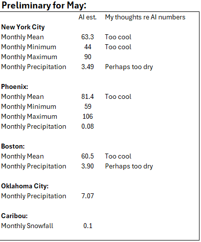
Some AI estimates for May: Final April numbers will be posted tomorrow.
-

E PA/NJ/DE Spring 2025 Obs/Discussion
KamuSnow replied to PhiEaglesfan712's topic in Philadelphia Region
Haha, just saw a lightning bug! First time seeing one in April. Sighting was confirmed by multiple flashes, and my wife saw it as well. Now if we could only get some aurora borealis here! -
@powderfreak wow, your dog is 10 now. Like Gene said, time does fly.
-
C-ya April. All in all not a bad one.
-
I'll take them over some contrarian pulling them straight from their ass.

-
Yep good call! Frost advisories out for Litchfield county. Spotty frost for Western Mass.
-
It will turn cooler tomorrow before warm air returns to the region ahead of an advancing cold front. The weekend will turn cooler again by Sunday. A wet pattern is likely Sunday through Wednesday. The ENSO Region 1+2 anomaly was -0.3°C and the Region 3.4 anomaly was 0.0°C for the week centered around April 23. For the past six weeks, the ENSO Region 1+2 anomaly has averaged +0.82°C and the ENSO Region 3.4 anomaly has averaged -0.05°C. Neutral ENSO conditions will likely continue through at least early summer. Early indications are that summer 2025 will be warmer than normal in the New York City and Philadelphia areas. The potential exists for a much warmer than normal summer (more than 1° above normal). The SOI was -6.71 today. The preliminary Arctic Oscillation (AO) was +1.619 today.
-

Spring 2025 Medium/Long Range Discussion
Jackstraw replied to Chicago Storm's topic in Lakes/Ohio Valley
Keep those 60 dewpoints south and I'm a happy camper. I know many like it hot but not me. I'll take 70's and 50's for as long as I can get them. Y'all will get your 80-90 degree days soon enough -
High of 74.5 here today. Can not ask for a more perfect day.
-
To my surprise ABC27 is calling for a similar event tomorrow evening, that we just experienced last evening.
-
Maybe slow gain, but slow decline as well get your Coppertone ready!
-
Roughly about 35 minutes remaining on sunrise gains and sunset gains. Slow gain on both between now and about June 21st. To @MJO812and @nycwinter hang in there !
-
looks frosty for the first morning of May here
-
What a shitty weather pattern coming up next week...ugh Sunday A chance of showers. Mostly cloudy, with a high near 63. Chance of precipitation is 40%. Sunday Night A chance of showers. Mostly cloudy, with a low around 45. Chance of precipitation is 40%. Monday A chance of showers. Mostly cloudy, with a high near 61. Chance of precipitation is 30%. Monday Night A chance of showers. Mostly cloudy, with a low around 45. Chance of precipitation is 40%. Tuesday A chance of showers. Mostly cloudy, with a high near 65. Chance of precipitation is 50%. Tuesday Night A chance of showers. Mostly cloudy, with a low around 52. Chance of precipitation is 40%. Wednesday A chance of showers. Mostly cloudy, with a high near 69. Chance of precipitation is 30%.
-
Weather apps?
- Yesterday
-
A couple showers for a week or two. No big deal.
-

2025 Spring/Summer Mountain Thread
Maggie Valley Steve replied to Maggie Valley Steve's topic in Southeastern States
We've had 3 showers with 2 that brought thunder across the Valley. Tomorrow looks even more active! Finished up putting down 90 bags of mulch this afternoon. Still need another 10 to 15 bags to complete that project before shifting to extensive pressure washing of decks. -
Wouldn’t be May without a week ruined by a cutoff.
-
They’ll be in the 60’s . The woodyard will be wet and Dewey
-
dews are fine its the heat dew combo that sucks


.thumb.png.e1f898d009b2415a204433df288e6f2a.png)


