All Activity
- Past hour
-

January 2026 regional war/obs/disco thread
CoastalWx replied to Baroclinic Zone's topic in New England
Like I said. It’s so satisfying to see these bums fall flat on their face. All the talk of storms and wild times….go eat shit. Love it. -
January 2026 regional war/obs/disco thread
CoastalWx replied to Baroclinic Zone's topic in New England
Your fault for buying those twitter idiots -
I'm becoming concerned about the cold push going west near the middle of the month. The West Atlantic Ridge is starting to pop up on globals
-
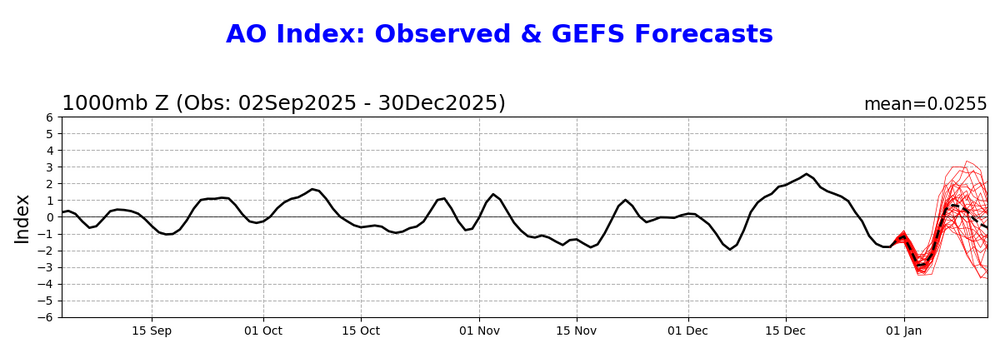
Natural gas, which usually drops when the high pop. centers of the NE US and Midwest look warmer in the 2 week forecast, is down >4%. The forecasted -EPO/+TNH cold pattern for the central US eventually looks great for cold domination prospects for the central US, much of the Midwest, and the N NE. But the biggest risk against sustainable cold is in the SE primarily and Mid-Atlantic secondarily, where the SE ridge may be too strong if the PNA in the means doesn’t go positive. This is very difficult to forecast this far out. Although I don’t like the warmer model developments of recent days for week 2 in the E US, my hope is still that the PNA in the means will flip for Jan averaged out to match the 100% of -ENSO -PNA Decs that went to a net +PNA for Jan. My other hope is that the 90 day -PNA bias of the GEFS/EPS/GEPS means that they’re currently off. The GEFS AO looks better for midmonth vs yesterday fwiw: Yesterday: Today:
-
t’s starting to look like a +TNH (-EPO) develops maybe just after we pass mid-January into late January. The caveat with +TNH patterns is that they are also correlated with +AO (+NAM), +NAO and a healthy SE ridge. So, while certainly arctic cold, it’s not going to be a “KU” pattern with ‘big dog’ snowstorms up the I-95 corridor, DC-BOS as some folks on twitter are saying. IF said +TNH pattern (-EPO/+AO/+NAO/SE ridge) develops just after mid-month into late January, it would argue for overrunning events and SWFEs. The question then becomes does it favor New England? Or PHL/NYC north into New England?
-
 DCA _ NYC _ BOS _ ORD _ ATL _ IAH _ DEN _ PHX _ SEA -1.9 -2.5 -2.4 -2.6 -0.8 +1.1 +0.7 +1.2 +0.4
 -
Historically, that's how we get a lot of our light to mod events.
-

January 2026 regional war/obs/disco thread
Typhoon Tip replied to Baroclinic Zone's topic in New England
I gotta warn y'all ... if this new paradigm as I just described to Brian, and is materialized with vivid coherence in all ensemble means, ends up as persistent as the previous N. Pacific ~ 4 week resonance we could end up observing some sort of partial or more analog to other notable -EPO --> +PNA hemispheres of the past. -
All the hype about big storms in early to mid January is gone. Models lost it.
-
Not getting digital blue on a 16 day ops run on Dec 31 is anti-ideal.
-
It would be so true to form for us to get a snowstorm sneak up on us at D5 while we lament the loss of a phantom at D10
-
January 2026 regional war/obs/disco thread
CoastalWx replied to Baroclinic Zone's topic in New England
To Kevin’s point, maybe we can get a little nrn stream involved Sunday -

January 2026 regional war/obs/disco thread
SJonesWX replied to Baroclinic Zone's topic in New England
before 2018, i averaged ~2 double digits storms per year. Since then i have had 5 in the last 8 years. 1/4/18, 12/17/20, 1/23/23, 3/4/23, 3/14/23 it's no coincidence that the winter of 2022-2023 was my only above-average snowfall season in that 8 years. -
^literally every model has trended towards: 1.) A storm 2.) More compact vort 3.) Closer to us
-

Central PA Winter 25/26 Discussion and Obs
canderson replied to MAG5035's topic in Upstate New York/Pennsylvania
It was nice to sleep last night. Thanks for calming down, wind. See you next week sometime. Hope we can get a coating to .5” with the squall tonight. Maybe we can time that and have two coatings! /badjpke -
Yes. 2” here in Perrysburg
-

January 2026 regional war/obs/disco thread
Baroclinic Zone replied to Baroclinic Zone's topic in New England
Yeah, how they go sometimes. I’m glad @The 4 Seasonsset up that archive, without it I’m lost as to my memories of storm dates. -
January 2026 regional war/obs/disco thread
Typhoon Tip replied to Baroclinic Zone's topic in New England
Nah the difference is that stubborn Date Line-ish -WPO hybrid stuck anomaly of the last 4 weeks is finally collapsing I explained all this yesterday, and at the risk of sounding like a dick ... it's right. When that leaves, the hemisphere is/was open in the guidance to establish a new "anchor" pattern - however transient or perm, notwithstanding. For awhile ...it appeared the +PNA might emerge, but then over 2 days ... that redrafted into this bono fide -EPO we see in all ens systems. Vivid coherence, too. I agree with Scott, that implies a warm up ... purely from climate inference. The magnitude of which, notwithstanding either. They can sometimes not manifest much N of 40 N ..for other popsicle headaches. However, highly correlated is a time lagged event whence cold starts to load into and eventually overcoming (or reinforcing either way) the native N/A circulation mode. This induces a +PNA 'drag' on the pattern, which then that takes over. I've seen this all take anywhere from 3 to 10+ days for the wholesale evolution to complete. Sometimes it is not a one and done wholesale show. 2015 was an extreme example of the -EPO --> +PNA relay, where it was pulsating. The EPO was negative for several weeks, and would dive additional 1.5 SD relative to the longer term bias; then recover, while the PNA would obey this time-lag and rise ...when it did, Logan put another 2 bits in the seasonal till. It was a perfect cold loader machinery at large synoptic scales. Other times it is all a more tepid and nuanced tale. Magnitude matters. I've seen these attempt in early April and it doesn't work out to well because the sun's annihilating the lower troposphere by then. etc. -

Winter 2025-26 Medium/Long Range Discussion
Frog Town replied to michsnowfreak's topic in Lakes/Ohio Valley
Just need to keep that -NAO in check so we don't end of CAD...In this pattern, a weaker -NAO(with all other things being equal) is a what we want. I know the east coasters hate this but what's good for them is not necessarily good for us. -NAO is good for us when it comes to maintaining a winter like pattern locally, but ideally after we have a deep snow pack. -
Yeah this is one of the things I point to for anyone that doesn't believe the planet is warming (e.g. people that try to use heat islands to explain away temperature increase measurements). This plus glacier loss makes it pretty incontrovertible.
-

January 2026 regional war/obs/disco thread
WinterWolf replied to Baroclinic Zone's topic in New England
WOR was the have nots in that one…only ended up with about 8” here of arctic sand with that one. A disappointment for sure. -
27 currently. Some blue skies breaking through.
-
New Years Day 2026 - 1st snows of the new year possible
CoastalWx replied to Baroclinic Zone's topic in New England
Ginxy area could do relatively well. Srly flow likes to dump moisture down his way. -
January 2026 regional war/obs/disco thread
WinterWolf replied to Baroclinic Zone's topic in New England
Yes. I think we(New England) will escape any real warmth. -
New Years Day 2026 - 1st snows of the new year possible
CoastalWx replied to Baroclinic Zone's topic in New England
They probably should.


