All Activity
- Past hour
-
For december, one would definitely want to be north of I-80. Even here, probably still dealing with rain from time to time.

-

November 2025 general discussions and probable topic derailings ...
ineedsnow replied to Typhoon Tip's topic in New England
Thats one of the places I eventually want to end up. Perfect for snow and cold with cooler Summers.. my area will do for now though -
Tanning oil out for TCC
-
 You can tell Tony is panicking because he keeps emphatically questioning anyone who isn't sold on a wintry December.
 -
86-87 was one of those years when the 45-“50” amounts went just to our south with the El Niño that year. Data for October 1, 1986 through April 30, 1987 Click column heading to sort ascending, click again to sort descending. SUSSEX 1 NW COOP 70.0 HIGH POINT PARK COOP 53.9 LAKEHURST NAS WBAN 53.3 ESTELL MANOR COOP 48.1 NEW BRUNSWICK 3 SE COOP 47.3 New Brunswick Area ThreadEx 47.3 POTTERSVILLE 2 NNW COOP 46.1 OAK RIDGE RESERVOIR COOP 45.5 INDIAN MILLS 2 W COOP 45.4 HIGHTSTOWN 2 W COOP 44.8
-
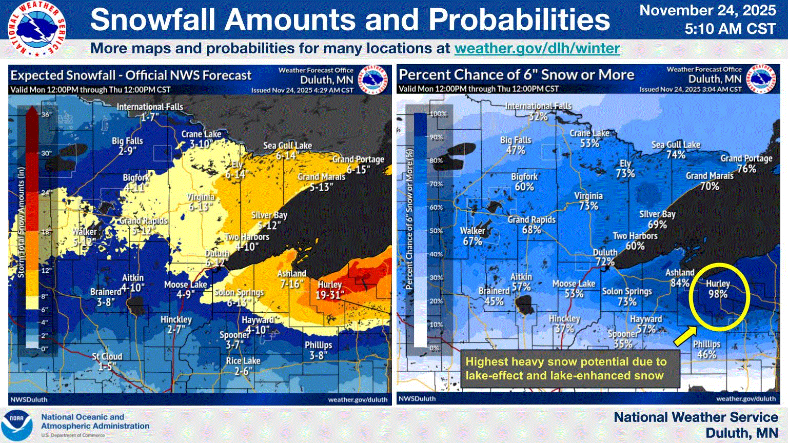
NWS Duluth getting frisky with this one. Here on the shoreline, expecting lower guidance 3-5". But the higher terrain could do well here. The bulk of the precip hitting at night when temps are a little cooler, coupled with colder air mixing in will help with this one. Ground will cool off fast, as well.

-

November 2025 general discussions and probable topic derailings ...
CoastalWx replied to Typhoon Tip's topic in New England
First week will be AN I think. Maybe after the 5th it cools off. We knew. -

Central PA Fall Discussions and Obs
pawatch replied to ChescoWx's topic in Upstate New York/Pennsylvania
Usually do 6-8 turkeys every year. Taking the year off this year. The wind really can make it difficult to smoke. Especially 30 mph wind gusts. -
This is amazing. Even putting the titles on each storm reference represents a lot of work, and is super helpful. High regards to all involved - great job!
-
 With a post like that.. what do you think lol
 -
Was the theme of the 80's as well despite some very cold snaps-storm track was either well out to sea or inland.
-
You guys need to smoke some weed
-
Also an emphasis on the name, "December LONG RANGE Discussion." A LOT can still change because we are in the LONG RANGE!! Especially when the pattern is so volatile and uncertain. People need to stop canceling winter so quickly
-
November 2025 general discussions and probable topic derailings ...
CoastalWx replied to Typhoon Tip's topic in New England
Useless since ensembles cover it. Flipped to what? -
I’m thinking not: Saturday A 30 percent chance of showers. Mostly sunny, with a high near 77.
-
I grew up hearing "north and west of the city" in the 90s for like literally every storm it felt like. Very frustrating for a kid who loved snow.
-
It seems as though the affected area is CPK/LGA through SNE. Eastern PA as well. I am in awe of how much snow the Delmarva region has been getting. I remember growing up it seemed to be always warm/wet cold/dry. I would watch the weather channel (before internet lol) and they would use the phrase "its just a cold SNAP for the northeast, temperatures will rebound nicely......". The delmarva area did extremely well back then also.
-

November 2025 general discussions and probable topic derailings ...
MJO812 replied to Typhoon Tip's topic in New England
Weeklies flipped for the 1st week of December. -
I’ll have to check it out. Thanks for posting this!
-
 Zzzzz
Zzzzz -
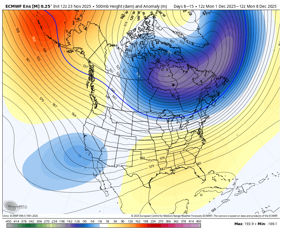
FWIW, 15 day changes
-

Fall 2025 Medium/Long Range Discussion
michsnowfreak replied to Chicago Storm's topic in Lakes/Ohio Valley
Who wants to start the Winter medium/long range thread? -
Chances of some snow around Thanksgiving are looking pretty good. SW to WNW wind. From Cle morning discussion "By late Wednesday evening into the early overnight hours, the cold front will have departed to the east, leaving much of the region under the influence of a surface trough. With 850mb temperatures quickly dropping into the -8 to -10C range, this will mark the beginning of an increasing threat of lake effect snow. Initially Wednesday night, a sustained southwest flow across Lake Erie should isolate the heaviest band north over Lake Erie and have minimal impacts to the snowbelt minus possibly along the immediate lakeshore. By Thursday morning however, the upper level trough axis shifts east of the area and overall flow across the lake gains a more WNW wind component. This is expected to result in lake effect snow gradually shifting inland across the primary snowbelt. As this happens, ample moisture combined with deepening EQL and moderate lake induced instability should result in areas of heavy lake effect snow through Thursday night. Overall structure of the lake effect should be multi-bands with embedded heavier bands. Confidence continues to increase that there will be accumulating snow across portions of the snowbelt through Thanksgiving, but exact snowfall totals, locations, and timing remain uncertain. Given the increased travel surrounding the holiday, please keep up to date with the latest forecast and plan accordingly"
-
2025-2026 ENSO
michsnowfreak replied to 40/70 Benchmark's topic in Weather Forecasting and Discussion
Good snowfall pattern stretching from the upper midwest and Great Lakes into new England, with poorer snow chances in the midatlantic and points south is, again, classic Nina December. -
I see the same thing. Most of my buddies simply rely on their weather app, and will be standing in the pouring rain with me insisting there is a zero percent chance of rain...


.thumb.png.991e09c19c25af7391ed569a205a5136.png)


