All Activity
- Past hour
-
 74 /68 mostly cloudy wtih some hazy smoke mixed in. Clouds and mainly - mostly dry outside a stray shower or drizzle/light rain the next 24 hours. Clearing tomorrow and setting the stage for a wonderful 3 day period (too bad it wasnt a 3 days holiday weekend) as it looks gorgeous for any beach , outdoor, bbq, pool etc. Sunny, warm - 80s Fri - Sun/ upper 80s by Sunday. Flow comes around and expanding heat by Monday which should get the areas back into a widespread 90s for and through Thu or Friday, perhaps some strong heat Tue/Wed (95+). Beyond there outside a day or two near / slightly below normal its an overall warm- hot / humid and turning wetter. With tropics systems activity looking to stay persistent.
 -
you get the feeling that idiosyncrasies are teaming up to dim summer though. Smoke this, correcting toward over top highs that ( which import too much E wind ). This week was not going to be BN in the guidance and only turned out that way because of mitigating factors very poorly or not represented a week ago. Meanwhile, lower Asia over to Japan is apparently breaking all kinds of staggering high heat records... We are exiting the solar max in under a week. The first couple of weeks of the solar transition season that begins then will still feature hot enough sun - so it's not an all or nothing environmental aspect, it's a 'turning down the dimmer switch' thing. But, smoke days, and/or poorly models purely chaotically emerged confluence causing over-the-top heavy with +PP, we can't really do that while losing solar potency and expect things to toast up. So, I wouldn't call it "breaking summer's back" ...but it's not a hot implication. It's not helping ( me personally ) that both the spatial layout and telecon, both, are pretty nominal for heat at the moment. The operational runs also deflated some of the geopotential medium along 40 N E of Chicago, so ... they may still be showing some heat in their 2-m temperature distributions and so forth, but -deltas in the overarching metric, while these reasons to not get warm keep happening ... that's not really sending much confidence in heat, either. Stop with the idiosyncratic mitigators would help... That all said, I don't see a significant cold front, nor any compelling reason when studying the recency of the mass fields and the numerics therefrom, that argue for that, either. Mostly, it all looks rather torpid and frankly kind of a boring mid month. Things can change. Again, I wouldn't 86 the outlook for remainder of summer, either. I'm not buying any of the TCs up the EC by the GFS, which does this every year as seemingly perfunctory seasonal error by that model. There's are certain and significant correlated climatologically based structures all but required in the larger flow scheme, that do not include what the GFS is attempting to do.
-
 Can we get just ONE non dud winter? Like a february 2021 repeat?
 -
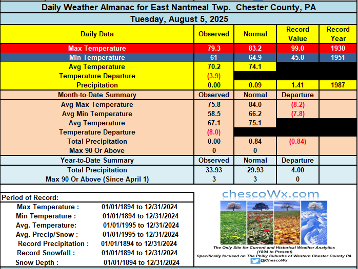
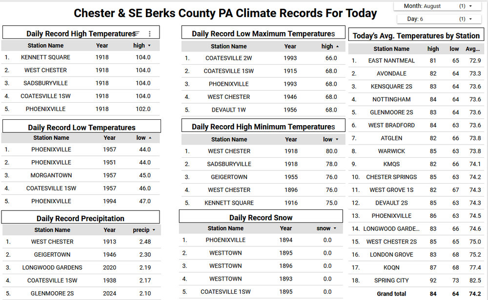
We have had 5 straight well below normal days in fact this is the 2nd chilliest start to August in my 22 years of records here in East Nantmeal behind only the start of August 2021. We should be closer to normal temperatures today before we fall back a few degrees below normal for Thursday through Saturday before we should start a nice warmup into the middle of next week. Cloudy with maybe some sprinkles today - otherwise sunny and dry for most of the next week.
-

E PA/NJ/DE Summer 2025 Obs/Discussion
ChescoWx replied to Hurricane Agnes's topic in Philadelphia Region
We have had 5 straight well below normal days in fact this is the 2nd chilliest start to August in my 22 years of records here in East Nantmeal behind only the start of August 2021. We should be closer to normal temperatures today before we fall back a few degrees below normal for Thursday through Saturday before we should start a nice warmup into the middle of next week. Cloudy with maybe some sprinkles today - otherwise sunny and dry for most of the next week.
-
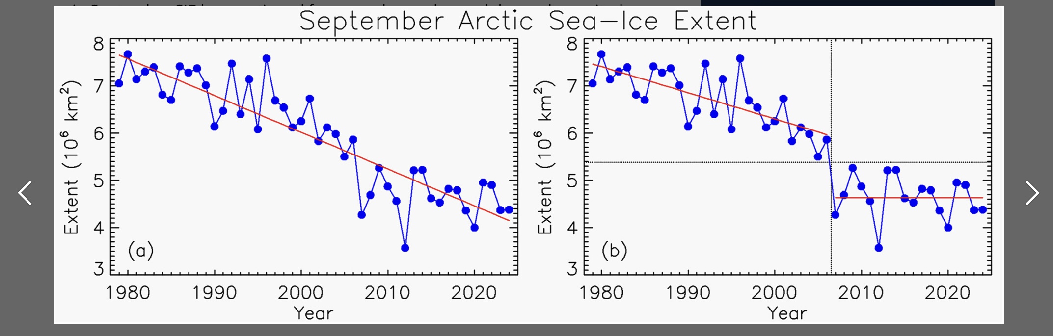
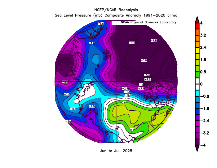
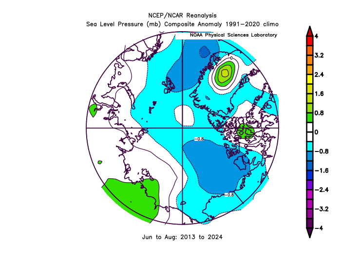
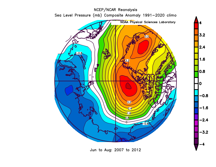
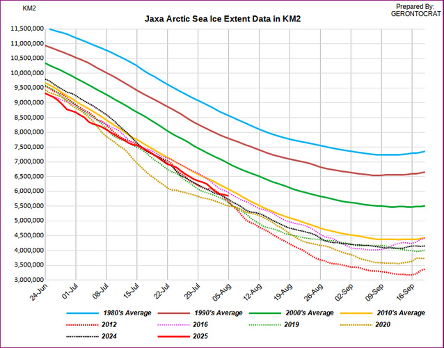
Right on cue the pace of Arctic sea ice loss has slowed behind the 2012 record drop experienced in early August 2012. That was at the end of an historic Arctic Dipole pattern from 2007-2012 leading to all the records over that 6 year period. This season so far has continued the much weaker Arctic Dipole pattern since 2013. So this changed summer Arctic circulation pattern since then has resulted in no sea ice trend since those steep declines. But the Arctic has seen increasing warmth over this period. So even with these more favorable conditions for Arctic sea ice retention, the sea ice thickness and extent has not returned to the pre 2007 state. Most Septembers finish between 4-5 million sq km over this period well below the major Arctic shift in 2007. I mentioned the melt pond data from early in the season which is one of the early indicators to look at. But this was the first year it hasn’t been published online. It probably would have shown something near the middle of the pack based on the lack of strong warmth this May. This was the opposite of the strong preconditioning in 2012 and 2020. 2012 was a perfect storm of a strong Arctic Dipole pattern following significant May preconditioning and the record Arctic cyclone in early August. These three features have not occurred in tandem since then. Special thanks to Gerontocrat from preparing the current extent which is in 6th place behind 2012. https://agupubs.onlinelibrary.wiley.com/doi/full/10.1029/2024GL114546

-
Summer 2025 The cloudy summer.
-
You never disprove the raw data you just say there must be some "kind of data issue" - or hey let's look instead at the COOP data since 2000 ... just moving the goalposts. Sure you can find altered adjusted data or conduct more faulty analysis that says otherwise, but that doesn't negate the findings from the high quality actual raw data.
-
oof check out how clueless the NAMs were on that midwest MCS lol. 6z run had his thing in Minnesota
-
I head we will lose on average about 2.5 minutes of daylight every day this month. .
-
Will be interesting to see if we get showers overspreading the region tonight. The 3km has been pretty consistent with this. It also I think kind of overdoes light precip but it (along with the HRRR) have that slug of precip. off NJ
-
Bit but The models won't be able to sniff it out until it's right in our backyard. You need to use the Moregarbage model to get ahead of it
-
 Central Tropical Atlantic: A tropical wave over the eastern tropical Atlantic continues to produce a broad area of disorganized showers and thunderstorms. Environmental conditions are forecast to be conducive for gradual development during the next few days, and a tropical depression could form late this week or over the weekend as the system moves generally west-northwestward to northwestward across the central tropical and subtropical Atlantic. * Formation chance through 48 hours...low...20 percent. * Formation chance through 7 days...medium...60 percent. Forecaster Patel
 -
Lol, I’ve been enjoying Summer with the family, but I’m really looking forward to Winter Storm tracking season!
- Today
-
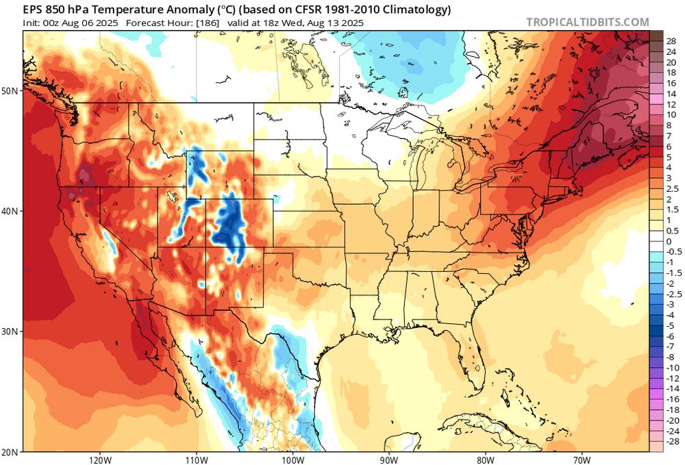
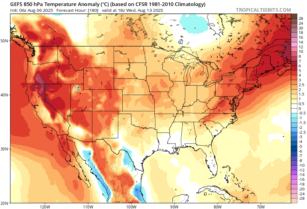
Euro is hot. Oh boy oh boy oh boy oh boy.
-
Dam voice over
-
I played both a million years ago. If I remember correctly you don't want to be off the fairway. Lots of bad lies. Especially if it's wet. Doesn't look like it it's going to be.
-
Finally getting a soaking rain. 1” and counting
-

E PA/NJ/DE Summer 2025 Obs/Discussion
JTA66 replied to Hurricane Agnes's topic in Philadelphia Region
Had a passing shower in the wee hours this morning, was not expecting that. Might be the only rain we see for a while. 70F/DP 66F -

2025 Atlantic Hurricane Season
LongBeachSurfFreak replied to BarryStantonGBP's topic in Tropical Headquarters
Let’s see how the next two waves preform. If they develop and help moisten the mdr its game time. Until then it’s follow the vertical instability to the subtropics. -
+6 78 Right around the cut line headed into round 2.
-
You can avoid that by being insufferably whiny all the time like me. Beats the unpredictability of sudden mood changes.
-
The ones at Ohare?
-
The fact people keep posting his tweets here gives him more clicks and folks talking about him . He thanks you
-
The great cold front of Mid August 2025 looks impressive.