All Activity
- Past hour
-
Oh wow tunnels? I had no idea that it piled up that much. So I guess that 1978 still ranks as #1 around here then? I'm so confused because everyone is saying how this was more than 1978 but I guess not.
-
I have had constant snow on my roof since the January 26 storm. Not sure that has happened since I've lived here
-

Central PA Winter 25/26 Discussion and Obs
Ruin replied to MAG5035's topic in Upstate New York/Pennsylvania
Yep called it -
Yeah mid week on could be dicey.
-
I just paid to boost my Bronze level pass to what is essentially a Gold (really Silver) at the local bump. Wife already has a Silver so now we can see during the day on weekends for the remainer
-

Late February/Early March 2026 Mid-Long Range
Stormchaserchuck1 replied to WxUSAF's topic in Mid Atlantic
80F sounding on 18z GFS -
Why do people keep saying this. Most likely grass but it does accumulate in March.
-
Looks more like 2 days to me.
-
true!
-
Yeah... @HIPPYVALLEY might jack with this
- Yesterday
-
Let’s just get thru tomorrow 40’s to near 50 in spots and then back to winter for a week at least . And then expect the torch to continue to look less and less with backdoor and strong HP up north
-
Manifesting warmth and active weather for all this month ahead
-
78 had so much more w/e as well roads were tunnels
-
Meteorological Winter precipitation stats for Smithtown. Feb 28 looks dry, so here's the final tally. From December 1 - February 28, 10.33" of rain or melted equivalent fell. The recent average is 13.02" Of the total, 4.40 inches fell as rain and 5.93" fell as snow or sleet. Total snowfall was 51.3" (average ratio of 8.7:1 for snow events). 57.4% of winter precipitation fell as snow or sleet. There was no significant freezing rain during this period. There were a total of 49 days with 1" or more of snow on the ground at 9am. As of 2/28 there has been consecutive snow cover for 35 days (since 1/25). There were an additional 12 days with a trace on the ground at 9am. Note: for January 1 - February 28, 76% of total precipitation fell as snow/sleet. (4.60" out of 6.00"). Snowfall for the 2 months was 38.3" yielding an average SWR of only 8.3 to 1 during the two traditionally coldest months. The 13" of snow in December averaged a more traditional 10 to 1 ratio.
-
31 in Feb, 24 max depth in 03
-
https://youtu.be/WChTqYlDjtI?si=ihkIV9p-ArrNKPnD
-
Happens i guess
-

Winter 2025-26 Medium/Long Range Discussion
Frog Town replied to michsnowfreak's topic in Lakes/Ohio Valley
I think this includes all of us.. -
Euro is still paltry but all other guidance is 1-3”. Maybe even iso 4” in the western highlands.
-
Everything kind of banged back south somewhat
-

E PA/NJ/DE Winter 2025-26 Obs/Discussion
RedSky replied to LVblizzard's topic in Philadelphia Region
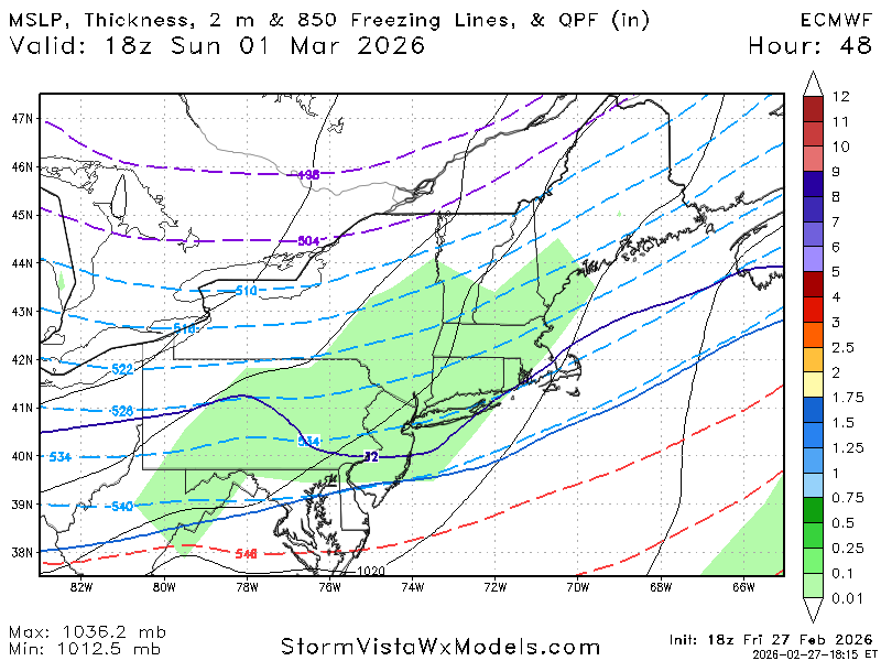
Guidance support today for a PV split and invasion second half of March -
Are you making a forecast map? I'd be interested in seeing it.
-
Lol blessed

-
Def in your area for sure. Your area struggled a bit in December ‘02 after the 12/5 event. Not as bad as the coastline, but Xmas storm there was pretty sloppy and even the 1/3-4/03 storm was much higher totals northwest. So you didn’t build the huge snow pack that northwest of 495 in MA did. Pretty hard to beat Feb 2003 there though. I think the 2/7 event and PD II gave you 3+ feet.
-
18z guidance looked good for SNE