All Activity
- Past hour
-
This cold is just unrelenting. 17.6 degrees here with winds at 8 and gusts to 20. It is simply brutal out.
-

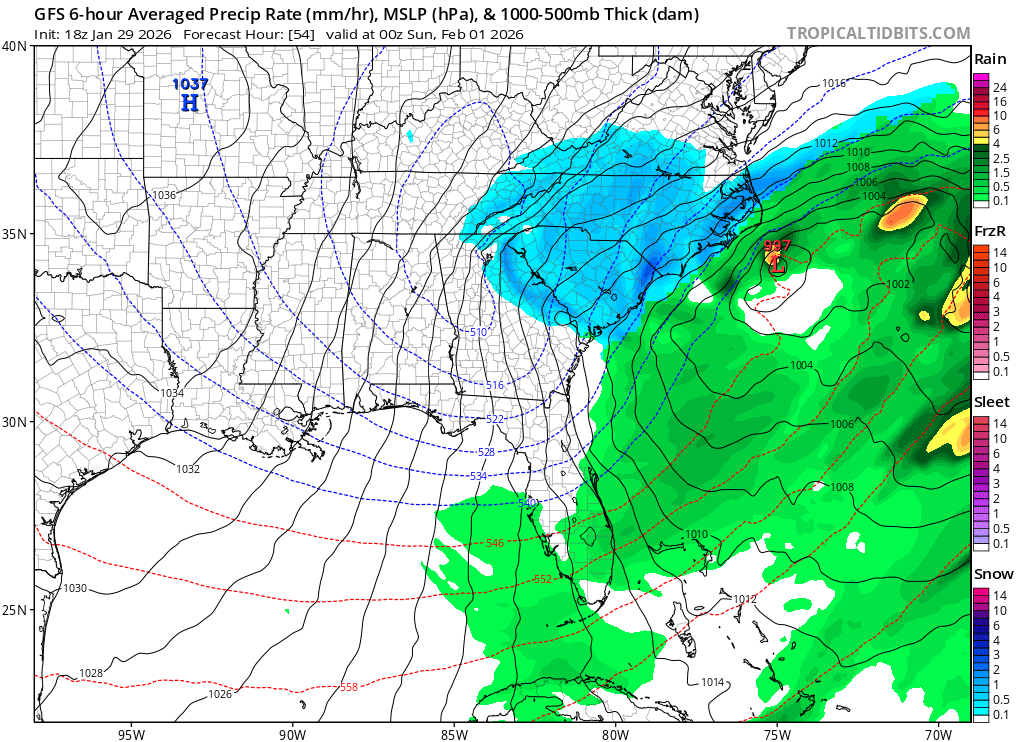
The “I bring the mojo” Jan 30-Feb 1 potential winter storm
Ravens94 replied to lilj4425's topic in Southeastern States
Going to be a huge hit for mostly all.
-
An icy New Haven Harbor today looking west from the Pardee Seawall Park.

-
I will also credit the WVLT met, as he said expect snow showers in the extreme cold that isn't showing up on models. This will be one of those situations where the dgz is probably around 2500 feet and up so snow will fall and it will seem to come from nothing on radar.
- 414 replies
-
- 1
-

-
- extreme cold
- snow
- (and 1 more)
-
Gfs looking to be another great run.
-

Central PA Winter 25/26 Discussion and Obs
Ruin replied to MAG5035's topic in Upstate New York/Pennsylvania
Yesterday it got to twenty three.When the forecast was twenty today, we were at twenty six when the forecast was at nineteen severe surprise.At temperatures got that high.Considering, we were supposed to only be in the team -
icon ensemble would see 4-5 in RIC
-

February 2026 Medium/ Long Range Discussion: Buckle Up!
Terpeast replied to Weather Will's topic in Mid Atlantic
Feb 4-6 is looking more like a minor event, hope we can tap into that. Otherwise Feb 11-14 looks like something with more moisture to work with. -

The “I bring the mojo” Jan 30-Feb 1 potential winter storm
Sickman replied to lilj4425's topic in Southeastern States
I think I'm more curious to see how the people down here react to what would be barely considered a moderate storm on Long Island. -

1-30/2-1-26 Arctic Blast, ULL Snow Event
Daniel Boone replied to John1122's topic in Tennessee Valley
They have their in house from what I gather. WJHL does too. They said theirs was similar to the GFS. -

February 2026 Medium/ Long Range Discussion: Buckle Up!
GreyHat replied to Weather Will's topic in Mid Atlantic
Unfortunately that seems to be what we're looking at cold and dry. At least next week being in the mid 30s will help melt this ice we have. MD2 in Arnold has had bobcats digging one of the lanes out around College Parkway. There are only 2 lanes. -
The “I bring the mojo” Jan 30-Feb 1 potential winter storm
Ravens94 replied to lilj4425's topic in Southeastern States
This should be a good run ! Energy is starting to consolidate near the closed low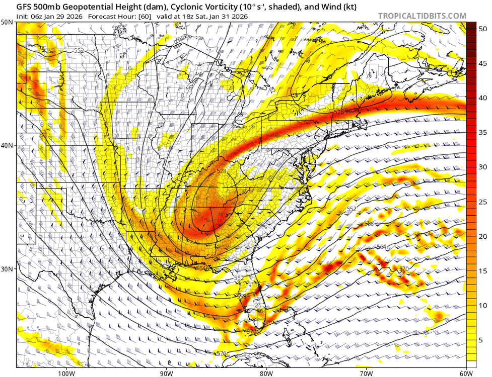
-

Central PA Winter 25/26 Discussion and Obs
Voyager replied to MAG5035's topic in Upstate New York/Pennsylvania
It's going to feel like 53. -
Don - you shared the table below of NBM snowfall inputs last week, but I simply can't imagine how the new NBM is more than the last run and how either of them could be right even with the wetter SREF inputs, as I think everything else should be near zero, except for low amounts from the EPS. And if it were just an academic question it might not be a big deal, but the NWS regularly refers to it in their AFDs, so clearly they use it, which I don't get. Any insight?
-

The “I bring the mojo” Jan 30-Feb 1 potential winter storm
Regan replied to lilj4425's topic in Southeastern States
Ok. Rah just posted their slides and said no real change from AM thoughts. Sam graphics. Still going with the 2:49AM thoughts too. Only added some could see less. But broad brush is 8-10in. they clearly aren’t ready to slice NC into 3 parts yet. Per what Mike Maze keeps saying the euro suggests. -
That’s actually insane. So many will finish December and January below normal and we’re on our 3rd (some 4th) accumulating snow event with two or three flurries thrown in. I think the next 3 days will decide how this winter is remembered but dang, that’s not a bad stat line
-
Yep, good to see. They are one of the best offices out there
-
They actually raised our high end amounts to 12…. And they are forecasting 7. .
-
From SPC meso…. The snow burst in eastern NC and southeast VA depict 700-500mb lapse rates >6.5C/km Saturday afternoon and evening where 2”/hr rates with thundersnow is likely. .
- 414 replies
-
- 3
-

-
- extreme cold
- snow
- (and 1 more)
-

Possible coastal storm centered on Feb 1 2026.
ChangeofSeasonsWX replied to Typhoon Tip's topic in New England
I know I'm not the only one thinking this but even if this one does miss us, I really hope that we can at least score another moderate or major event before the winter ends. It would be nice. Why cant Feb 2015 be the climo norm every winter? lol -
The “I bring the mojo” Jan 30-Feb 1 potential winter storm
Ravens94 replied to lilj4425's topic in Southeastern States
Gfs is changing in the NE every run. This run may cut off faster also.
-

Possible coastal storm centered on Feb 1 2026.
Damage In Tolland replied to Typhoon Tip's topic in New England
Solid trends so far kicking off 18 Zed -

The “I bring the mojo” Jan 30-Feb 1 potential winter storm
KChuck replied to lilj4425's topic in Southeastern States
Mine also -
NWS still seems pretty bullish here .
-

The “I bring the mojo” Jan 30-Feb 1 potential winter storm
wncsnow replied to lilj4425's topic in Southeastern States
118 members strong! Glad to see the site popping!