All Activity
- Past hour
-
Today is my baby's gender reveal to see if my wife will be having a boy or girl.
-
Ask Scooter . He posted it yesterday
-

Hurricane Erin - 75 mph - 996 mb - WNW @ 18
GaWx replied to BarryStantonGBP's topic in Tropical Headquarters
Yeah, no change in winds, but the minimum SLP did drop 3 mb to 993 mb. -

Occasional Thoughts on Climate Change
Typhoon Tip replied to donsutherland1's topic in Climate Change
The problem with that analysis/method is that it doesn't consider alternate pathways that may also be capable of forcing thermal distribution. It only assesses observations in support of his idea. -
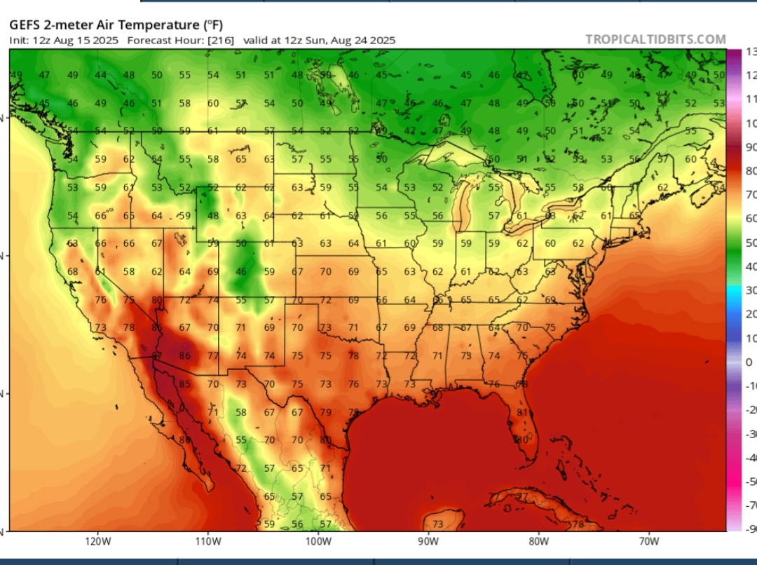
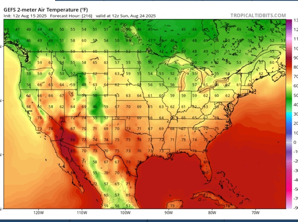
Isn’t that valid at 8am on Sunday?
-
90 + the weekend after next? You sure about that chief?
-
just need to lift that out a bit and move it up the coast before it gets kicked out.. 6 days out anything can happen and its close enough where we track
-

Hurricane Erin - 75 mph - 996 mb - WNW @ 18
Wannabehippie replied to BarryStantonGBP's topic in Tropical Headquarters
Latest advisory on Erin, no change in intensity. 2:00 PM AST Fri Aug 15 Location: 18.6°N 56.8°W Moving: WNW at 17 mph Min pressure: 993 mb Max sustained: 75 mph -
It seems that the musings back in July about the Atlantic SST profile being unfavorable for a big tropical season were correct in spite of a -ENSO. @DonSutherland1 was spot on with his call of a -AAM regime setting up in August as well
-
Just like in winter, Not getting anything into NE with that look.
-
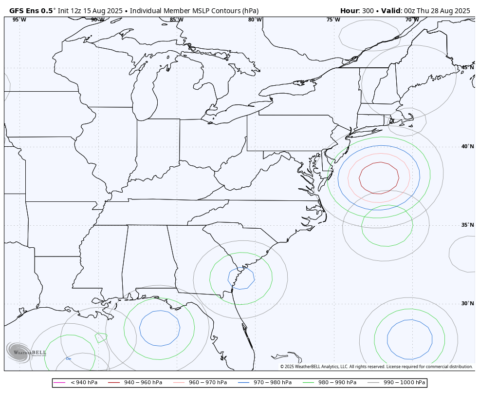
The ridge developing around Nova Scotia is the most interesting piece. The "giant" gyre is also sliding east and north with time... It's the feature of a developing -NAO...
-
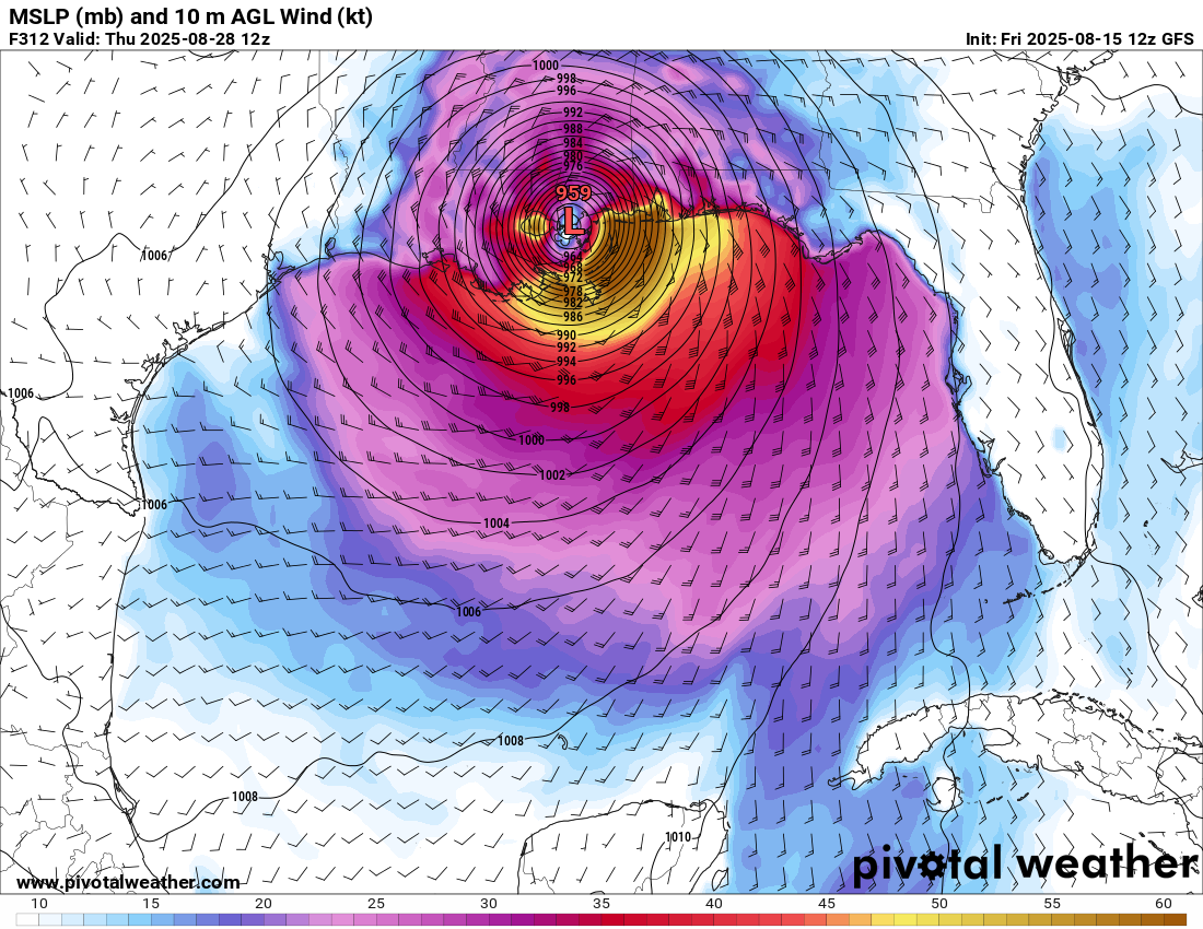
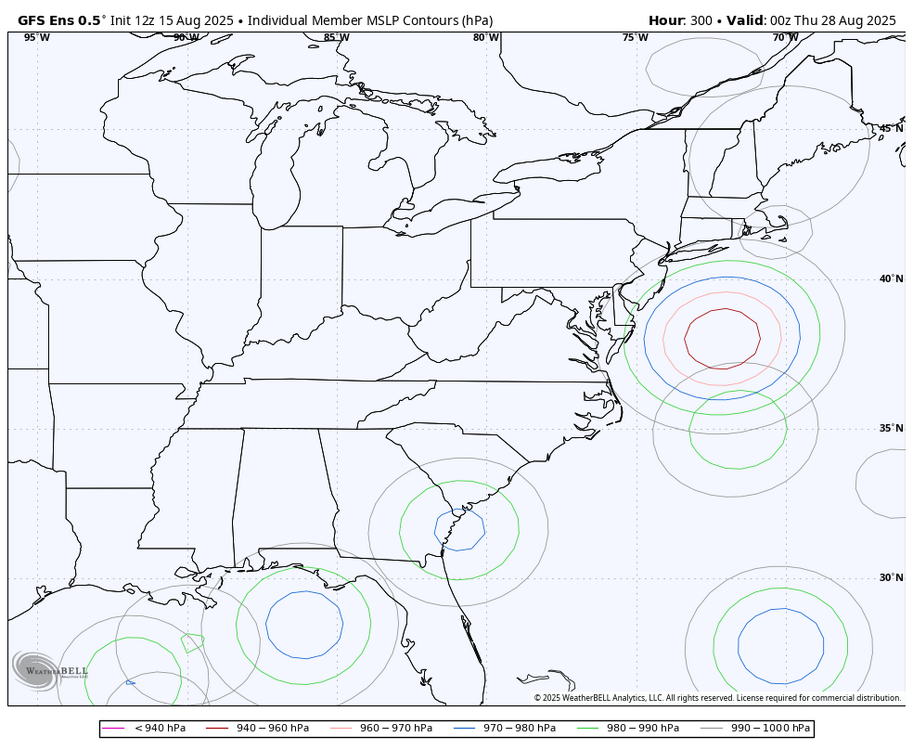
I count 8 of 30 (27%) of 12Z GFS ensemble members landfalling on the Conus from TX to ME within 8/27-9. GEFS suggests the MJO will most likely then be in phase 5, a rather active phase for Conus though not as active as phases 2 and 8. This is keeping me with a moderate concern for now: But the 12Z Euro like the 0Z has no TC from this. Also, it isn’t on the 12Z CMC. So, we’ll see. I already noted the 12Z UKMET with it.
-
 I just hit 90, so it's a 6 day heat wave here!
 -

Hurricane Erin - 75 mph - 996 mb - WNW @ 18
BarryStantonGBP replied to BarryStantonGBP's topic in Tropical Headquarters
another quote from another forum USTropics Professional-Met Posts: 2663 Joined: Sun Aug 12, 2007 3:45 am Location: Florida State University Re: ATL: ERIN - Hurricane - Discussion #419 by USTropics » Fri Aug 15, 2025 12:58 pm I feel much better about the Bahamas and United States after the 12z data has come in, we're looking at some potential squalls, significant riptides, and beach erosion as the main concern here for the islands and United States (Bermuda is still a bit unknown right now, but looking better). Here is the latest 10-run GFS trend with the 12z data (which has the strongest Erin yet in 72 hours): So basically the strength and position of the high pressure (red) and ridge extension (pink) determines the recurve alley (purple) here, not so much the strength of Erin. The best way to see potential scenarios is to look at the ensemble runs, and that will give us an idea of what different strengths of Erin means to the track. GEFS was the last remaining ensemble suite that was showing a more gradual turn to the north, and as a result some ensemble members were impacting the Bahamas or the potential for a Carolina scrape. The 12z GFS ensembles has only one remaining member that is doing this gradual turn now (and it does not impact the Bahamas or Carolinas directly): Compared to 06z ensembles: Here are 06z ECMWF ensemble members: 2 likes -
Hurricane Erin - 75 mph - 996 mb - WNW @ 18
BarryStantonGBP replied to BarryStantonGBP's topic in Tropical Headquarters
WaveBreaking Category 2 Posts: 594 Joined: Sun Jun 30, 2024 11:33 am Location: US Re: ATL: ERIN - Hurricane - Discussion #420 by WaveBreaking » Fri Aug 15, 2025 1:04 pm My take on Erin’s current environment. -
No one’s fault but your own there . Was pretty obvious for a while this had no chance lol
-
Sudden pop-up shower over Fairfax City. Pouring at GMU right now. But patches of blue sky are still visible!
-
12Z HRRR and 3K NAM could hardly be more different with the timing and placement of convection over WI over the next 48 hours.
-
I lost sleep tracking this
-
Water dependant all summer long
-
This is about as clear a recurve pattern as you can get for the US east coast. Has been for days and days...
-

E PA/NJ/DE Summer 2025 Obs/Discussion
JTA66 replied to Hurricane Agnes's topic in Philadelphia Region
Just hit 90F. Only made it to 86F yesterday, so that's 3 out of the last 4 days at 90F or above. Maybe not an official heat wave, but heat wavey enough for me - Today
-
2025 Atlantic Hurricane Season
BarryStantonGBP replied to BarryStantonGBP's topic in Tropical Headquarters
Happy birthday Kat
-
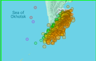
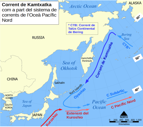
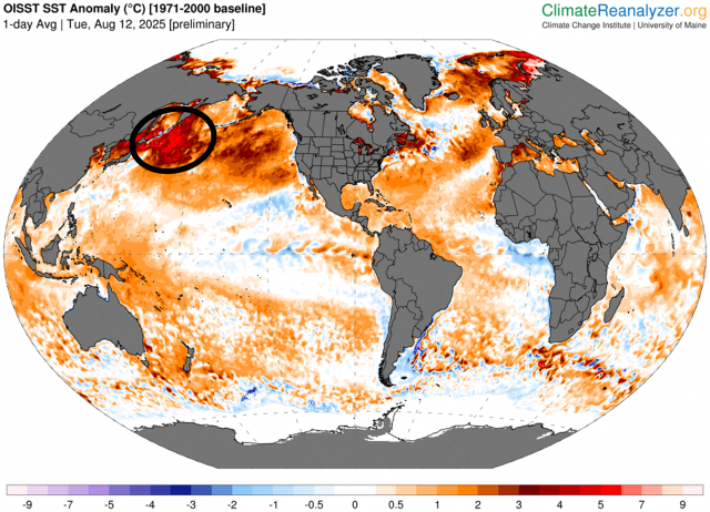
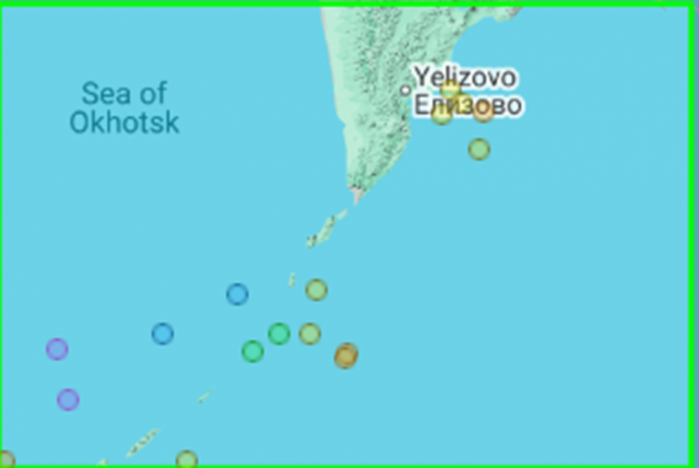
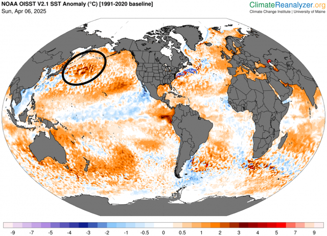
From Dr. Viterito via JB 8/14/25: I've been keeping a very close eye on this area, as it has been a geothermal hotspot helping to feed the Kuroshio Current, the Pacific's equivalent to the Gulf Stream. Did you notice at the very end of the video the narrator talks about the fact that geothermal heating enables the major port to be ice-free year round and that the area is used as a submarine base? "The "culprit" here is the submarine activity of the Eastern Volcanic Front off the east coast of Kamchatka." As the map shows, there has been a tremendous amount of underwater seismic activity in this area for the past 30 days. For the record, there have been 1036 seismic events, the vast majority of which are associated with underwater magma displacement. Keep in mind, these magmas can reach temperatures of 400 degrees C! IRIS/Wilber 3, Mx >=3, July 15 - August 14, 2025. The water off the east coast of Kamchatka moves southward vis the Kamchatka current. Here is a map of this: Wikidata The Kamchatka Current then feeds the Kuroshio Current, and in this case, is providing exceptional warmth to the Kuroshio. This is starkly illustrated in today's sea surface temperature map. In this map the source region is clearly the southeast coast of Kamchatka, and we can see that excess warmth being transported by the Kamchatka Current, which then merges with the Kuroshio. By contrast, here is the seismic map for March, 2025. For that month, there were only 17 seismic events: IRIS/Wilber 3, Mx >=3, March 6, 2025 - April 5, 2025. Here is the resultant SST map (April 6, 2026 [sic]): Clearly, the "hot spot" was much weaker when the seismic activity was lower. It can be argued that the Kamchatka source region is responsible for the large temperature anomaly the Kuroshio is currently experiencing. It's about time the climate community starts to recognize the importance of geothermal inputs into the system. ————————— Any comments?
-
0.0% chance. Stop being stupid.