All Activity
- Past hour
-

2025-2026 ENSO
40/70 Benchmark replied to 40/70 Benchmark's topic in Weather Forecasting and Discussion
Where did you pull those graphics from? -
 Stunning lenticular cloud yesterday.
 -
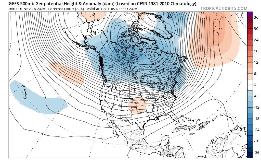
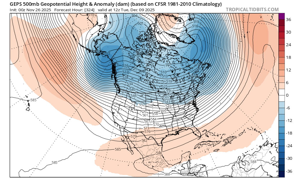
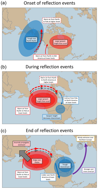
Really good recent paper here when considering this stratosphere wave reflection event. I feel like this influence is taking control of things for a bit. And models are trying to resolve this influence. As it does fit in with what we're seeing, and what models are doing. Which, if it is, then begs the question. What takes over once the life cycle runs its course? And when? Since the end dates apparently vary (but are typically ~2 weeks) and aren't very well understood. It's interesting. Probably a future case study. Dynamics of stratospheric wave reflection over the North Pacific https://wcd.copernicus.org/articles/6/521/2025/
-
2025-2026 ENSO
40/70 Benchmark replied to 40/70 Benchmark's topic in Weather Forecasting and Discussion
Absolutely this. -
This early rain is more of an option. But if it flipped and coated that’s a win.
-
I suspect this split forcing is the reason for the volatility that we have been seeing in the models for the first 10 days of December. Models struggle with the placement of features when there are multiple areas of forcing. My only guess that I made earlier for December is that we will have a weaker -PNA and colder Canada than last year.
-
2025-2026 ENSO
40/70 Benchmark replied to 40/70 Benchmark's topic in Weather Forecasting and Discussion
The MJO is but one factor that can either constructively, or deconstructivity interfere with baseline forcing.....what you implying is akin to saying that I jog 3x weekly, so I know I'm very healthy....come to find out, I also smoke 6 packs a week, inhale MacDonalds 3x daily and have casual unprotected sex with one-legged prostitutes on a nightly basis. -
I thought the 6z EURO and 6z AIFS made steps to meet each other in the middle (what we want). Would’ve loved to see a few more frames of the 6z EURO.
-
2025-2026 ENSO
40/70 Benchmark replied to 40/70 Benchmark's topic in Weather Forecasting and Discussion
I don't care how much crap can be dug up from AI, the strat stuff is pretty useless. -

December 2025 Short/Medium Range Forecast Thread
Carvers Gap replied to John1122's topic in Tennessee Valley
Overnight modeling definitely interesting. -
It will be interesting to see whether this split forcing, if it happens, is a continuation of the VP standing wave over the MC, or is a second wave propagating eastward from MJO 6>7>8>1. There is agreement that the first (current) wave is going to propagate into 8 and 1 in the coming days (according to both GEFS and EPS hovmoller charts), which makes sense as we're already tracking some wintry threats on the way next week. (and when I say wintry threats, I'm not saying it's going to snow imby, just talking generally over a broad area in the E and NE)
-
EPS looks pretty decent for a week out. I like seeing those gulf lows a bit offshore at this point. We know how those can trend.

-
EPIC run of GFS...one storm next week and at fantasy range....

-
It’s becoming more and more obvious where this is heading, despite the run to run changes on the long range ensembles….the stratospheric warming/wave reflection event looks to stay completely decoupled from the troposphere, then the SPV reconsolidates and strengthens quickly going into mid-late December. You, @so_whats_happening @donsutherland1 and @bluewave did a very good job explaining the expected MJO progression. Once we get towards mid-December, it is looking very likely that the Alaskan ridge regime retrogrades to an Aleutian ridge regime, the EPO goes +, a healthy -PNA pops and the SE ridge pumps
-
Yeah could be old school pond skating by 12/15 if some of these runs are correct.
-
Most here wouldn’t love that but wouldn’t mind if they got 20” next week.
-
Is it just me that worries about the pattern flipping to a torch around Christmas week? Trauma from years past I reckon.
-
I’ll be the hater here: Why would we have such a big snowstorm down to the shore in an early part of the season (first week of December) when we usually don’t? (I’m aware that it’s snowed during this time in the past, et. al.) The universe usually aligns against it. Ok, I’d enjoy being wrong, but interested in knowing why it would occur. Thank you and safe travels today! .
-
Well... it is chock full of stuff to watch, at least this run LOL. My gut says next Wednesday WILL happen, simply because I'm covering my buds snowplow route and I REALLY don't want to!
-
After today not much sign of any warmth. Skating by mid December?
-
40mph gusts all night making it impossible to measure but it looks like guidance was to bullish on snow totals. Seems like a 1-3” type event eyeballing from my kitchen.
-
Sure would like to know your definition of southern edge lol
-

Central PA Fall Discussions and Obs
Mount Joy Snowman replied to ChescoWx's topic in Upstate New York/Pennsylvania
Low of 44 with .58” of rain and dense fog this morning. Looks like I’ll have to start dialing in a bit more on mid next week. -

November 2025 general discussions and probable topic derailings ...
UnitedWx replied to Typhoon Tip's topic in New England
48 both locations here with some pretty thick fog on the way in to the office... and idiot drivers running high beams -
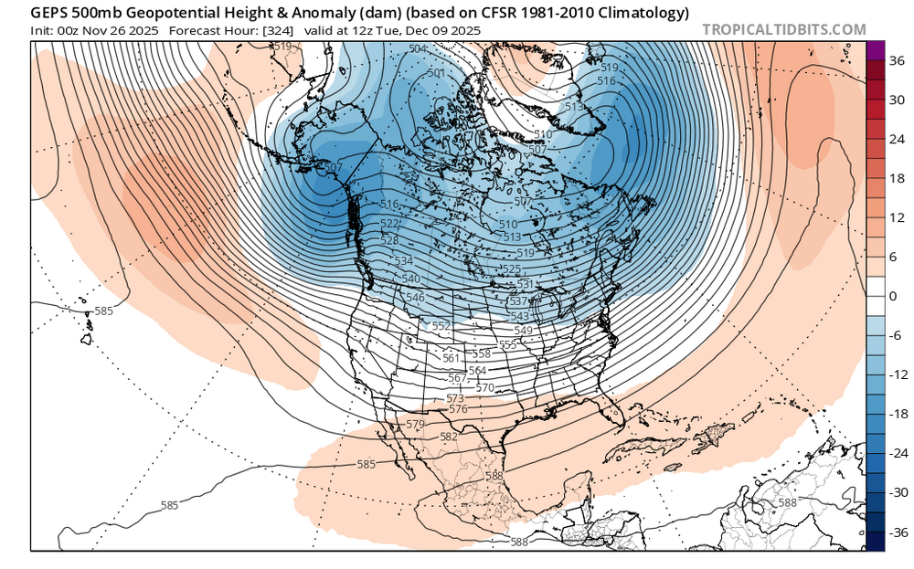
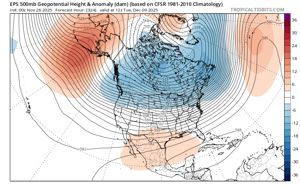
These long range OP runs can be very pretty. You can see a very broad -PNA trough developing in the ensemble means. Ongoing tug of war between the competing forcing influences On one hand you have the forcing near the Maritime Continent causing the -PNA trough. The 2nd factor is the forcing over the Western Hemisphere trying to build a ridge bridge over the top from Northern Greenland to the -WPO ridge. I suspect this split forcing is why we are getting a composite blend very long range between a Phase 6-7-8 look. The RMMS may try to slow the progression on the 7-8 border in response to split forcing. So at this point I would say early December will feature a broad gradient type pattern with cold across the Northern tier. Mid month will depend on the progression of the forcing. if the ridge bridge over the top wins out, then we will know a phase 8 is trying to take hold. If the -PNA and +EPO become more dominant and the trough pulls back to the west, then we will know the forcing near the Maritime Continent is having a greater influence. Recent experience has favored the 2nd option of a relaxation of the pattern mid to late month. If this doesn’t happen, then we’ll know something new is taking place which we haven’t seen in a while.