All Activity
- Past hour
-
Yeah it’s too bad that thin band down by Plymouth isn’t going due north. That would’ve given us a solid soaking for sure. We’ll take whatever we can though!
-
Weakening tstm but we’ll take the rain.
-
Thunder?!
- Today
-
It's a naked swirl
-
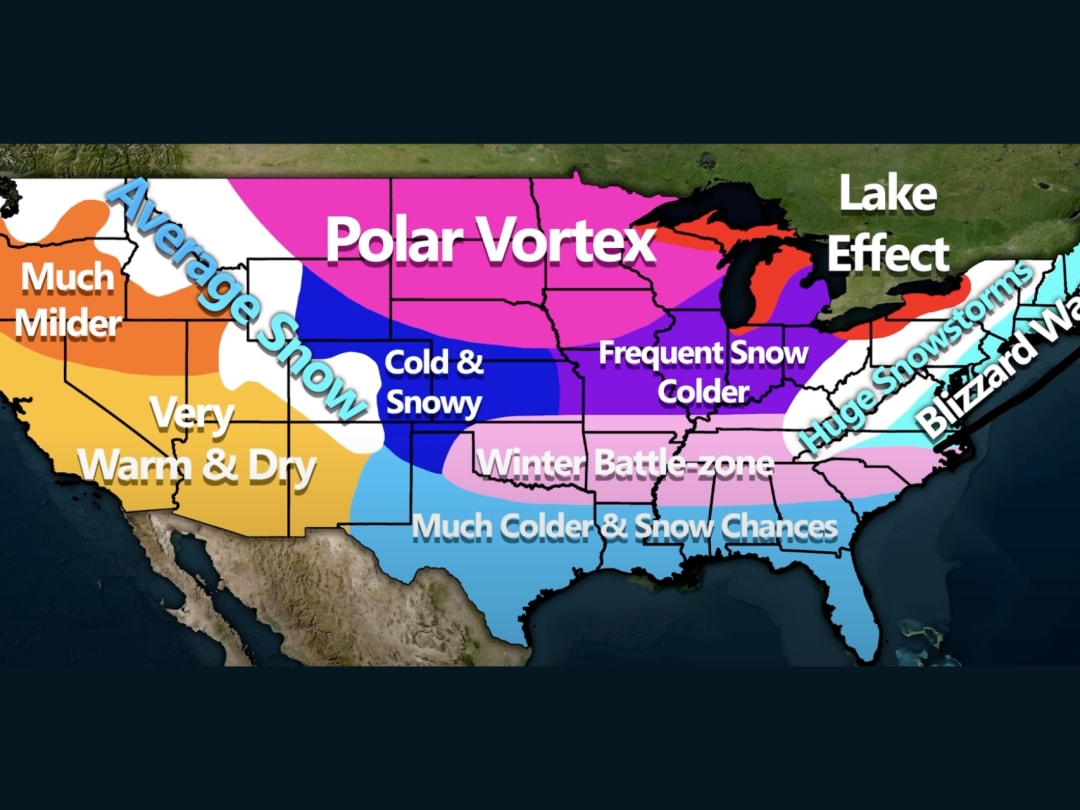
Was this one posted before? I get them all mixed up with their typically fictitious southern battle zones and NE blizzard watches and huge snowstorms and N Plains polar vortices and amazingly enough always warm/dry in the W where E US wx weenies conveniently don’t care: https://www.powder.com/news/east-coast-blizzard-watch-winter *Edit: I just noticed that this is the one posted yesterday that I even commented on lol. I told you guys I get these mixed up and this is proof!

-
Of course! Although if the background forcing is prohibitive enough it starts to become like those trick shot videos where they are shooting baskets off of buildings
-

2025-2026 ENSO
so_whats_happening replied to 40/70 Benchmark's topic in Weather Forecasting and Discussion
Man a lot to catch up on but it surely has been fun watching the forecasts for MJO over the last week or so. Also just saw OISST just updated they have been doing upgrades so things have been delayed quite a bit, call me whatever but I have this feeling we bottomed out already for ONI numbers will have to see as we go into early October if we continue to see it flatline if not rise. I forget how to look the post up for this I made earlier in the thread but still liking the idea of this look as we go into winter.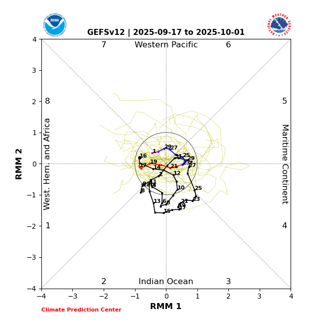
-
But isn’t a KU a pretty random event that can happen in just about any winter if things happen to line up? In other words, isn’t there at least some KU potential every winter (I realize the probabilities vary each winter) because it’s random?
-
2.88” for the day. Tack on the .27” from last night and that was a solid rain that was needed.
-
I’m not sure how much sleep I’ll get tonight in anticipation of tomorrow’s NWS drought monitor maps.
-
Only 0.11 of lt rn, dzl, mist today
-

September 2025 OBS-Discussion centered NYC subforum
lee59 replied to wdrag's topic in New York City Metro
Total rain here today 0.00 inches. Now a week of dry weather coming up -

September 2025 OBS-Discussion centered NYC subforum
SACRUS replied to wdrag's topic in New York City Metro
Highs: ISP: 74 PHL: 73 LGA: 72 JFK: 72 TEB: 71 EWR: 70 TTN: 70 New Brnwck: 70 NYC: 70 ACY: 69 BLM: 66 -
Post menopause women most definitely do not prefer warmer indoor temperatures lol
-

September 2025 OBS-Discussion centered NYC subforum
anthonymm replied to wdrag's topic in New York City Metro
Definitely not any time within the next 3 weeks. -

September 2025 OBS-Discussion centered NYC subforum
donsutherland1 replied to wdrag's topic in New York City Metro
The system responsible for today's showers and periods of rain will slowly move away from the region tonight and tomorrow. As a result, clouds will break tomorrow morning and a partly to mostly sunny afternoon will follow. Temperatures will return to the upper 70s tomorrow and then rise further into the lower 80s on Friday. The warmer spots could see some middle 80s on Friday. Cooler air will return for the weekend with another warmup possible starting early next week. The ENSO Region 1+2 anomaly was -0.2°C and the Region 3.4 anomaly was -0.5°C for the week centered around September 10. For the past six weeks, the ENSO Region 1+2 anomaly has averaged +0.10°C and the ENSO Region 3.4 anomaly has averaged -0.37°C. La Niña conditions will likely develop during mid- or late-autumn. The SOI was +4.93 today. The preliminary Arctic Oscillation (AO) was -1.179 today. Based on sensitivity analysis applied to the latest guidance, there is an implied near 51% probability that New York City will have a cooler than normal September (1991-2020 normal). September will likely finish with a mean temperature near 69.1° (0.1° below normal). Supplemental Information: The projected mean would be 1.1° above the 1981-2010 normal monthly value. -
Full event total of 0.91" for my area in Londontowne/Edgewater. I'll take it since we needed any rain. Things were already greening back up I noticed as I went out this evening. Congrats to those who cashed with that rain today. I love seeing areas that need rain get smacked
-
Looks like between .25-.30 in the gauge, rained for about 30-40 minutes. This is the most rainfall since 8/24 when a similar north to south storm came thru (0.79), again like that event, this one has blown up a bit and raining good down towards Roanoke. Hopefully not as much as back in August for them (3-5").
- Yesterday
-
Amazing day today! Summer is back! High of 91, low of 68....oh, and a half inch of MUCH needed rain from a thunderstorm!
-
.12" here. Helps keep the dust down
-
Gabrielle looks terrible on satellite photos. Stretched out, mid and low level circulation centers are disconnected. https://zoom.earth/storms/gabrielle-2025/
-
The Drake! https://x.com/danbury_wx/status/1968447867619533167?s=46&t=dhcbvkjmRcyBVQtDxJ3lRg
-

September 2025 OBS-Discussion centered NYC subforum
LibertyBell replied to wdrag's topic in New York City Metro
You must like turning on your heat, I don't even want to think about doing that before November -

September 2025 OBS-Discussion centered NYC subforum
wdrag replied to wdrag's topic in New York City Metro
Wantage NJ this part. about 0.10. (NOT zero). -
Nice, 0.10” here. Not much but well received


.thumb.png.4150b06c63a21f61052e47a612bf1818.png)


