All Activity
- Past hour
-

January 24-26: Miracle or Mirage Thread 2
NorthArlington101 replied to mappy's topic in Mid Atlantic
GFS is a 1’+ for everyone, and I pretty much mea everyone. Hope it’s doing okay thermal wise. Nice to see the hires FV3 also chilly. -
Gfs looks like mulit prog system again
-
Yeah, either it's on to something or on something. On and island by itself tho, so...
-
And you will notice the wild swings stop and begin to form a solid line of best fit
-
GFS is more of a two-parter than some of the other models. First comes through cold and all snow. Looks like the 2nd is going to be latitudinally-dependent. 00Z Monday DCA
-

Richmond Metro/Hampton Roads Area Discussion
overcautionisbad replied to RIC Airport's topic in Mid Atlantic
Are we trending boys? Are we back? Will it snow? Can I put the generator away? -

Possible Record Breaking Cold + Snow Sunday 1/25 - Tuesday 1/27
SACRUS replied to TriPol's topic in New York City Metro
-
6z Monday heavy non snow precip still going on
-
I mean, 18z sunday and the mix line is still south of EZF...
-
Gfs is colder cause the isn’t driving into Toronto
-
0z Monday, GFS has another slug about to roll in.

-

Pittsburgh/Western PA WINTER ‘25/‘26
Rd9108 replied to Burghblizz's topic in Upstate New York/Pennsylvania
Gotta smell the sleet they say -

January 25-26 Winter Storm Potential
CoolHandMike replied to Ralph Wiggum's topic in Philadelphia Region
First probabilistic snow maps out. Only goes through Sunday 7am: https://www.weather.gov/phi/winter -
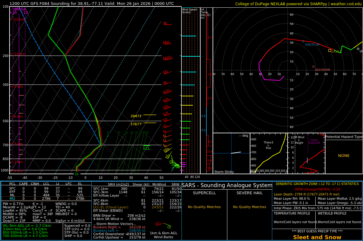
@BornAgain13it is going to be SUPER close on thermals with initial thump as well on GFS. Hr 66 has the death band set up basically directly over the 460 corridor.
-
Let's see if it goes back to the quick transfer then wrap around snow
-
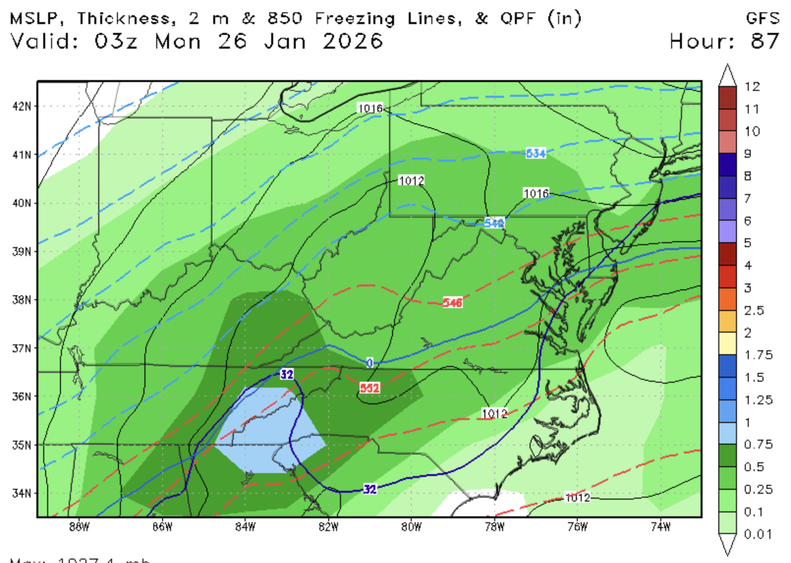
That's a loooooong precip shield at 18Z Sunday. Still all snow .
-

1/24-1/25 Major Winter Storm - S. IL, IN, MI and OH
Chambana replied to A-L-E-K's topic in Lakes/Ohio Valley
5.3” final call $ -
Possible Record Breaking Cold + Snow Sunday 1/25 - Tuesday 1/27
SACRUS replied to TriPol's topic in New York City Metro
-
You will be able to keep beer cold outside for awhile after it.
-
 I find that thumps in SWFEs tend to underachieve a bit and mix quicker than modeled. I think the higher ceiling depends on if the costal gets going but otherwise looks like a 6-8" to sleet type of deal for coastal areas. Those in Rockland and further NW look to be in a great spot for major snows but 6-8" would be the biggest storm in years for coastal areas so we'll certainly take that.
 -
Much clearer predictive picture at that point- they are now working closer to the mean and not the tails- much more robust data points
-
It’s probably because this thread is used for medium/long range pattern prediction while threads in each sub forum are used once an individual threat becomes realistic.
-
GFS is colder...initially...just kinda hard to discount the NAM thermals. It does tend to do well with thermals and can serve as a warning. But it is just outside the useful range. I'd just rather not totally ignore it
-
Heights have been showing up a bit lower in Quebec on the 12z runs so far. The stuff out west is still amped, so it’s actually a good combo for a lot of us because it runs into an even more stout brick wall than before which will increase QPF
-
12z sounding is clean at DCA. Warmest is about -5C