All Activity
- Past hour
-

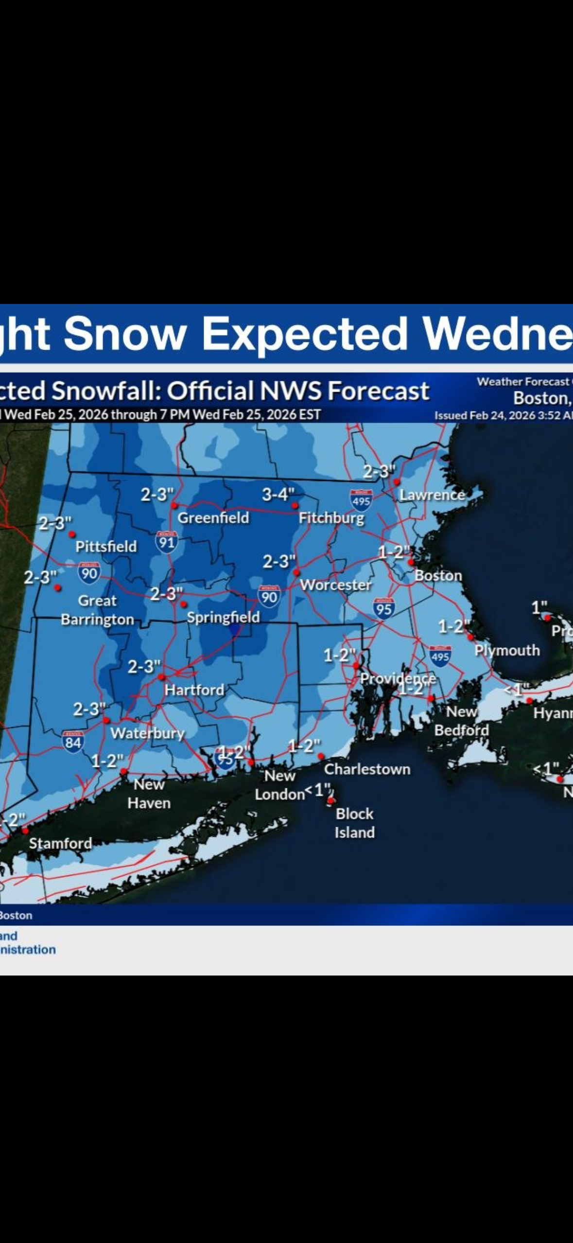
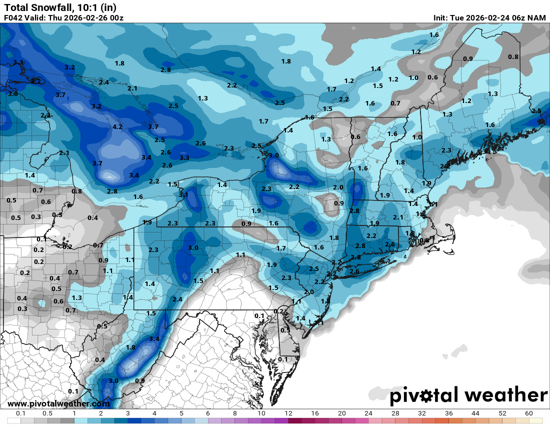
Clipper Fires In Wednesday Feb 25 Disco/ Obs
Damage In Tolland replied to Damage In Tolland's topic in New England
Another snow day tomorrow? And then we’ll see about Thursday night
-

"Don’t do it" 2026 Blizzard obs, updates and pictures.
kdxken replied to Ginx snewx's topic in New England
Heard that before. -

Late February/Early March 2026 Mid-Long Range
Weather Will replied to WxUSAF's topic in Mid Atlantic
WB 0Z EPS for early next week.
-

February 2026 OBS & Discussion
North and West replied to Stormlover74's topic in New York City Metro
Getting concerned about flood potential in the usual places. [emoji51] . -
Late February/Early March 2026 Mid-Long Range
Weather Will replied to WxUSAF's topic in Mid Atlantic
WB 0Z EPS shows maybe enough cold air with the negative WPO early next week, lights out for at least a while by the end of next week as warm air surges east.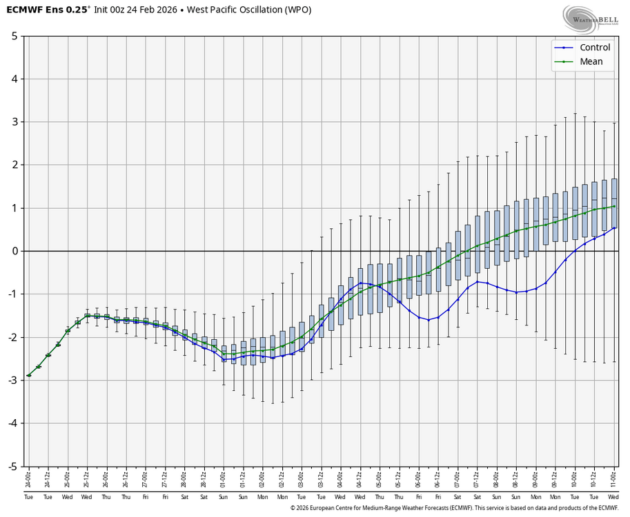
-
Late February/Early March 2026 Mid-Long Range
Weather Will replied to WxUSAF's topic in Mid Atlantic
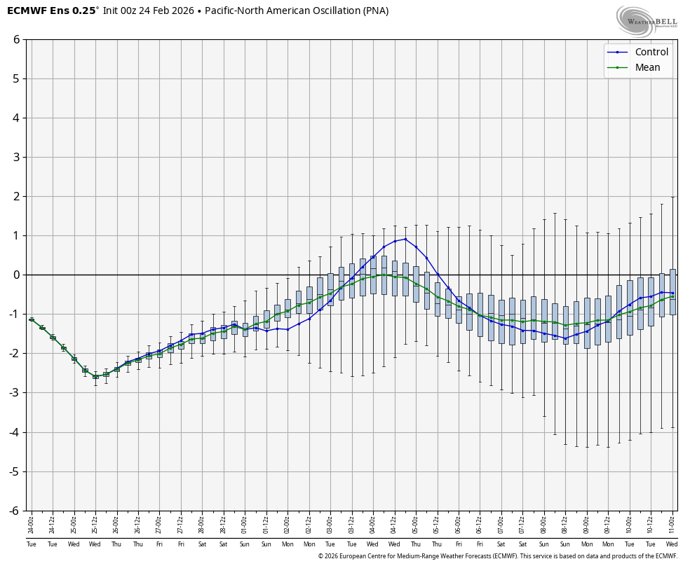
WB 0Z EPS PNA support for early next week as well.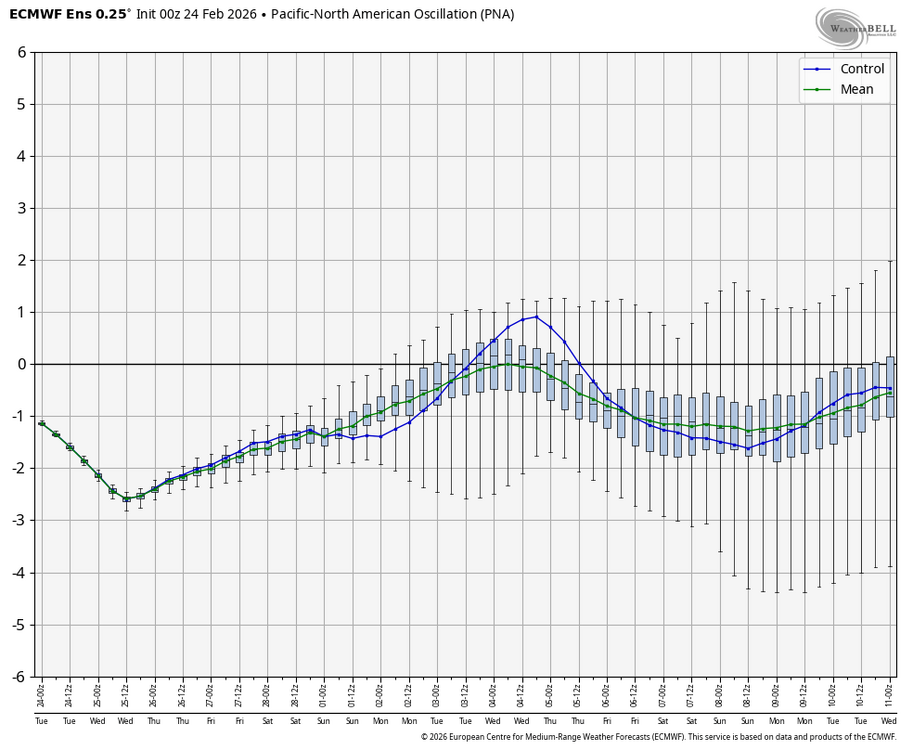
-
Late February/Early March 2026 Mid-Long Range
Weather Will replied to WxUSAF's topic in Mid Atlantic
WB 0Z GEFS has the early next week threat as well.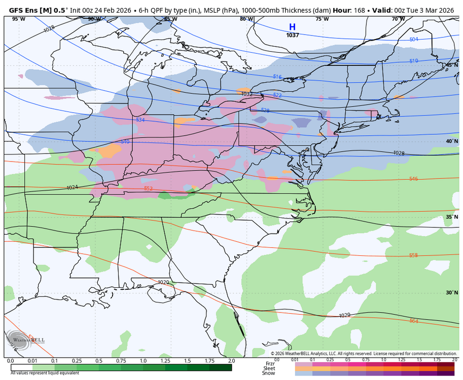
-
March 2-3 still looking interesting with a weakish wave moving eastward underneath cold HP to the north.
-
Light flurries this morning still. It's very calm out there currently. Low of 12 degrees with another half inch picked up overnight it looks like. Might have been an inch but the wind was whipping everything around. So my storm total is 7.5 inches. Not too freaking bad at all.
-
Regardless, it looks like you nailed the SSWE even if it happens in March, you were only a few weeks off. You’ve basically nailed the entire winter since November. Impressive and congrats. As far as mid-late March, I believe the SSW/SPV split forecasts. It likely causes high latitude blocking just after mid-March. Whether or not it benefits people south of New England’s latitude as far as more snow? Who knows
-
Our total in Westfield is 8 inches. Same at a friend's house in Southwick. 12 inches even at my shop in Simsbury
-
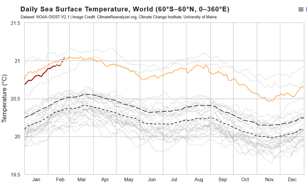
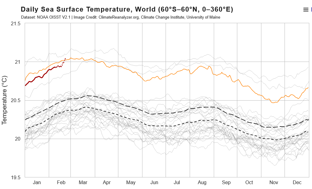
SST trend so far this year is consistent with a nino spike to record temperatures, bit it is early in the nino cycle. I took years between 2010 and 2022 off the chart to better isolate 2023 and later at the top of the chart. On the chart, 2023 is the coldest of the 4 recent Jan and Feb, red is this year and orange 2025. So far this year SST are tracking 2023, but roughly 0.15C higher. The recent spike in SST has brought 2026 above 2025, approaching record SST in 2024. 2023 moved into record SST territory in mid-March. This year is on a similar pace.
-
Southwest corner of Ellington.
-
Here's a link to the Cansips SSTA starting in November. Looks basinwide with a lean to the west. Not a classic Modoki imho unfortunately. But the key will be the PDO and blocking coupled with this forecast, right or wrong. Forecast will be updated this weekend. https://www.tropicaltidbits.com/analysis/models/?model=cansips®ion=global&pkg=ssta_noice&runtime=2026020100&fh=9
-
Evolution of nino usually starts as east based then broadens to basin wide and ends as modoki as coastal South America cools/upwells. This time we should probably use RONI for the strength of el nino because the tropics are also warm across the board.
-
I have just seen the new CF6 tables through Feb 23 and no changes were evident, totals are still NYC 19.7, LGA 22.5, ISP 29.1, JFK 20.1, EWR 25.2
- Today
-

Winter 2025-26 Medium/Long Range Discussion
A-L-E-K replied to michsnowfreak's topic in Lakes/Ohio Valley
Zzzzzz -

"Don’t do it" 2026 Blizzard obs, updates and pictures.
Roger Smith replied to Ginx snewx's topic in New England
What is the period of record for the PVD snowfall record set yesterday? I have mentioned before having the daily weather journal of Alexis Caswell at Brown University in Providence spanning winters 1831-32 to 1859-60. In all of those winters, some quite severe, there are no two-day snowfall events (indicating storm totals) greater than 20" ... these are a few of the larger storm totals he recorded ... the largest storm total in Feb was 15.0" (1846) and in March 9.5" (1835). For Nov the max was 10" (29th 1841). All of the largest falls were in the three winter months except for one in April (1841). Jan 5-6, 1856 ___ 20.0" Jan 18-19, 1857 __ 18.0" Apr 12-13, 1841 __ 18.0" Dec 29-30, 1853 __ 18.0" -

"Don’t do it" 2026 Blizzard obs, updates and pictures.
TheSnowman replied to Ginx snewx's topic in New England
Well I’m not talking, I’m typing, so no can do. And does a 6 year old explain fully in detail the explanation of everything being thrown at them? You simply can’t handle negativity, even if it’s in text form; everything must be happy and positive. That’s an actual 6 year old, or being Woke. And I’m on an “Illegal” Weenie Run, finding out I was CORRECT in my assessment of these snowfall amounts. Doing 6 towns tonight and 6+ more tomorrow. Will show the results later. -
3k nam
.thumb.png.1f7585679a9a55125d44974d62416509.png)
.thumb.png.d7d8c290945657da2c26c555930f5b60.png)
-
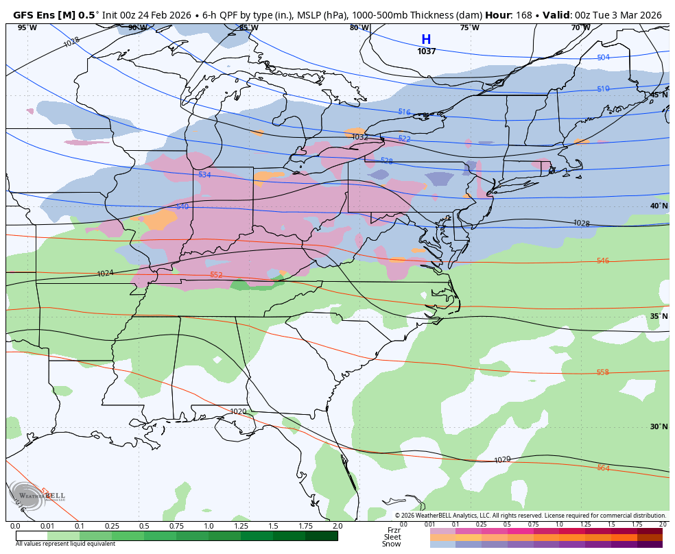
Nam for clipper
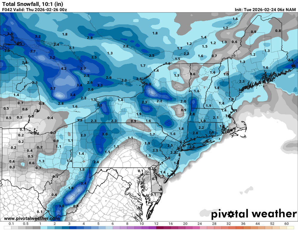
.thumb.png.30712a80bf9102b1124a079ffb865fa5.png)
-

Winter cancelled/uncancelled banter 25/26
Santa Claus replied to Rjay's topic in New York City Metro
me trying to follow the 13 snow events happening the next 7 days -

"Don’t do it" 2026 Blizzard obs, updates and pictures.
SnoSki14 replied to Ginx snewx's topic in New England
Signals for a major warm-up are growing after an early March cold shot. -
Howdy! I haven't posted in AMWX since late SEP 2014, a full 9+ years before I retired from the NWS (NWSFO ALB 1992-1994, WFO MLB 1994-2023). A friend sent me the link to the part 1 thread for the HECS in the Mid Atlantic forum for its quality memework. I peeped subsquent threads, and it was a fun follow. Congrats to all who scored big time with this one! Now that I've retired to my original home stomping ground of upstate eastern NY as of June 2025, I figured I'd dust off this account and start posting now and again. Quite a big change from the past, as pretty much all my prior posting was in the tropical forums/threads. Ironically, I was rewarded for moving with one of the worst winters locals can remember, in terms of both cold and snow, dating back to my first 31 years upstate - some have mentioned 77-78. I didn't follow winter storms all that much during my 30+ years down in ECFL. So far this winter, at my home in West Milton (western Saratoga County), I've received 56.2". Not bad for my first winter back. I look forward to re-kindling some online interactions on here!
-
I have checked full day calendar day 23rd climate reports and with one very minor exception the somewhat debatable numbers are confirmed. Annoyingly, EWR added 0.1" to their total. But NYC remains 19.7" despite potential for 1-2" additional after the early 1 p.m. report. I don't yet have any explanation for EWR showing up as 27.1" in PNS when their two daily amounts are 8.1 and 17.1 (previously 17.0). I will edit the table for those miniscule differentials for EWR. Doubt that it makes much difference to any rankings. Earlier in the process, I had hudsonvalley21 slightly ahead of MJ0812 because of the higher EWR estimate. There were other changes after that, at some higher value than 27" hudsonvalley21 would have a lower total squared error being a bit closer to any high value. That's why that part changed. I am going to check the CF6 data which is usually published around 5 a.m. for NYC area stations, to see if anything changes there -- the CF6 document was stated to be the ultimate guide to scoring this contest. Will either edit in a "no changes found" or tell you what changes I find. Later edit -- no changes to any contest snowfall values in CF6 tables. Remains 19.7 _ 22.5 _ 29.1 _ 20.1 _ 25.2 for two day storm totals.


.png.64f4efc7caa70e8b1623bdba09ec9826.png)
.png.837c87543119f26515e1a10ed6a2c152.png)
.png.0e58ce302466ab418dd9ef3ee572988b.png)
