All Activity
- Past hour
-

2025 Atlantic Hurricane Season
BarryStantonGBP replied to BarryStantonGBP's topic in Tropical Headquarters
WHERE SHE AT -

2025 Atlantic Hurricane Season
NorthHillsWx replied to BarryStantonGBP's topic in Tropical Headquarters
GFS and Euro kind of hinting at some home brew next week -
2025 Atlantic Hurricane Season
BarryStantonGBP replied to BarryStantonGBP's topic in Tropical Headquarters
WHO GAVE THE BLOODY FROGS CONTROL OF THE NHS PAGE NHC issuing advisories for the Atlantic on TS Fernand NHC issuing advisories for the Eastern Pacific on TS Juliette Marine warnings are in effect for the Eastern Pacific NOAA prediction remains on track for above-normal Atlantic hurricane season National Hurricane Center Products and Services Update for 2025 Hurricane Season Atlantic - Caribbean Sea - Gulf of America Tropical Weather Outlook (en Español*) 800 AM EDT Mon Aug 25 2025 Tropical Weather Discussion 1215 UTC Mon Aug 25 2025 Tropical Storm Fernand Satellite | Buoys | Grids | Storm Archive ...FERNAND MOVING NORTH-NORTHEAST OVER THE OPEN ATLANTIC WITH LITTLE CHANGE IN STRENGTH... 5:00 AM AST Mon Aug 25 Location: 33.7°N 58.8°W Moving: NNE at 12 mph Min pressure: 1007 mb Max sustained: 50 mph Public Advisory #7 500 AM AST Forecast Advisory #7 0900 UTC Forecast Discussion #7 500 AM AST Wind Speed Probabilities #7 0900 UTC Productos en español: (más información) Aviso Publico Pronóstico Discusión Wind Speed Probabilities Arrival Time of Winds Wind History Warnings/Cone Interactive Map Warnings/Cone Static Images Experimental Cone Warnings and Surface Wind Rip Currents Eastern North Pacific (East of 140°W) Tropical Weather Outlook (en Español*) 500 AM PDT Mon Aug 25 2025 Tropical Weather Discussion 1005 UTC Mon Aug 25 2025 Tropical Storm Juliette Satellite | Buoys | Grids | Storm Archive ...DEPRESSION STRENGTHENS TO TENTH TROPICAL STORM OF THE 2025 EAST PACIFIC HURRICANE SEASON... 2:00 AM MST Mon Aug 25 Location: 16.8°N 111.8°W Moving: WNW at 13 mph Min pressure: 1003 mb Max sustained: 40 mph Public Advisory #3 200 AM MST Forecast Advisory #3 0900 UTC Forecast Discussion #3 200 AM MST Wind Speed Probabilities #3 0900 UTC Productos en español: (más información) Aviso Publico Pronóstico Discusión Wind Speed Probabilities Arrival Time of Winds Wind History Warnings/Cone Interactive Map Warnings/Cone Static Images Experimental Cone Warnings and Surface Wind Rip Currents -
85.8 yesterday. Today is probably the only shot to hit 90 here this month and forecasts are for us to top out about 3 degrees shy. When the hot airmass is shy of 90 in August you are in a fantastic pattern. Didn’t realize it had rained a little this weekend but got 0.04” which brings the month to 9.18”
-
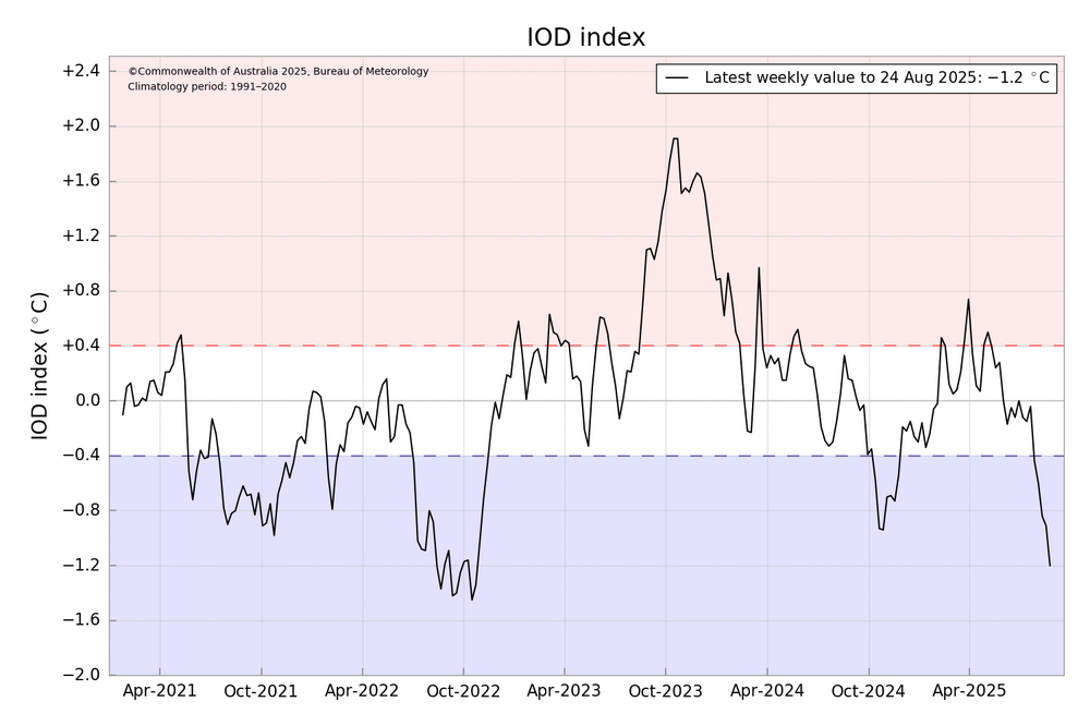
That strongly supports more of the same eastern IO and Maritime Continent forcing (MJO 4-5-6–7) with all of the warm SSTS in that region. Also supports Niña strengthening/EWBs, enhanced trades
-

2025 Lawns & Gardens Thread. Making Lawns Great Again
tamarack replied to Damage In Tolland's topic in New England
Maine public lands has had good results from seeding logyards and winter roads just before spring breakup. They can still get to the sites with the 4-wheelers with attached spreaders then and the catch has been satisfactory. Their seed mix isn't lawn grass; it's designed to limit erosion and provide food for wildlife. -
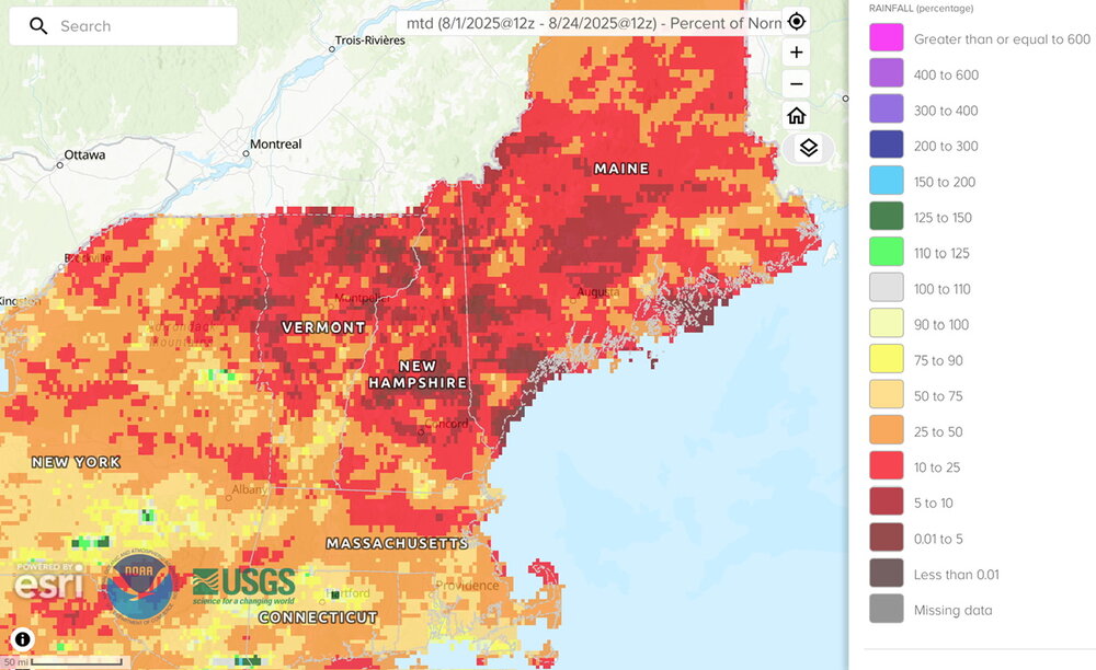
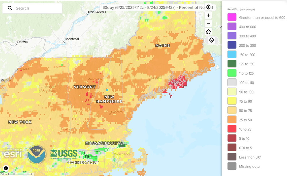
Ugly MTD and 60 days
-
There's a holiday weekend in our future; usually good for a few tenths at least. But I think the deficit is around 0.4". That's a lot even for a weekend.
-
So much for any storms today. We’re not even included in the general t-storm activity today…
-
Going up north this weekend the point and click forecast is as follows: Thursday A 40 percent chance of showers before 2pm. Partly sunny, with a high near 68. Thursday Night Mostly clear, with a low around 43. Friday Sunny, with a high near 71. Friday Night Partly cloudy, with a low around 44. Saturday Mostly sunny, with a high near 74. Saturday Night Partly cloudy, with a low around 48. Sunday Mostly sunny, with a high near 77. That 43 is going to be crisp, I do hope we hit the 77 because I do wanna go to the beach one of the days up there.
-
 Missed out on any rainfall overnight with the front. Expect some escalation in Drought Monitor over parts of the Northeast sector later this week. Still think we see some Severe Drought classification for parts of this sub forum before things get better. Extreme Drought classification for parts of the Northeast sector not out of the question. Absent any tropical activity pattern continues to look dry. Mainly of concern for AG interests and home gardeners.
 -
 Boo to 430 sunsets
 -
I drove through that stuff in the Toledo area on my way back from PA Saturday evening. It rained so hard for about 5 minutes people were pulling off interstate. I was doing about 10-15MPH and the lane lines were barely visible.
-
Game cam reported 52F at 7am at the cabin. Looks like some fog was in the area as well. Mid 60s in DC and feeling pretty comfortable. It's pretty crispy here, leaves falling all over the sidewalks, not that it's helped with mosquitoes. 69F down in Calvert right now, I'm going to head back down that way after dinner tonight.
-
can't imagine it's consequential much either way
-

2025 Spring/Summer Mountain Thread
Buckethead replied to Maggie Valley Steve's topic in Southeastern States
The temp dropped to 49 at my house this morning. I'm ready to get back to the mountains! I've been at Mammoth Cave NP for the past week, it's been hot the entire time here. Sent from my SM-S908U using Tapatalk -
Great phrase… “extra feral for snow” lol
-
 hillsborough duke just missed it but I got .05 in my neighborhood from a shower early this morning
 -
First -1.2 IOD in 3 years as they have become much more common over time with the warming SSTs near the Maritime Continent.
-
Yeah I didn't truly buy it but was hoping for like .10. Nada like the hrrr had
-
Something we've needed to consider the last few years. Euro on an island is JAM, and usually tossed. That can be brutal in winter though when the weenies get extra feral for snow
-
Do you really want LE rain? Wouldn't you want the lake to be as warm as possible going into the winter season? LE rain in August means that air temps are really cool, which would begin a drop in water temps and lessen the differential as we go into the cool/cold seasons. Asking because I don't know the answer.
-

2025 Spring/Summer Mountain Thread
Met1985 replied to Maggie Valley Steve's topic in Southeastern States
Fall weather has arrived. Had a low of 55 this morning and only going to get colder through the week. - Today
-
59.0 for low here, currently 59.3/58.8 with fog at 8 am.
-
Cant wait for the Euro to do that in winter… be the westward outlier with QPF…


