All Activity
- Past hour
-

2025 Lawns & Gardens Thread. Making Lawns Great Again
dryslot replied to Damage In Tolland's topic in New England
Lowes or Home Depot has it. -
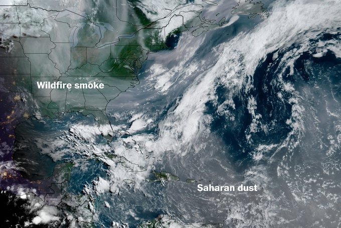
True. It was very hazy yesterday due to the smoke.
-

2025-2026 ENSO
michsnowfreak replied to 40/70 Benchmark's topic in Weather Forecasting and Discussion
Just a warning, some of us in the lakes forum have speculated that he is a former troll account. And same here; bluewaves theories, regardless of whether it is just to get the pattern correct, or its a convenient scapegoat to make nyc winters warmer/less snowy, or a mixture of both...would imply good winters here in MI so I would have NO issue with his outcome. I just dont like anyone talking in absolutes as if they have a crystal ball. While its very rare for NYC to have a better winter than here (tho it has happened- see 1957-58, 1960-61, 1995-96), it's a little more common for NYC to have a more favorable pattern for their local climate than we have for ours (even if the end result is still a "wintrier" winter here). So these assumptions that NYC is just never going to have a good winter barring a volcano eruption are imo ridiculous regardless of ANY background factors, let alone all of them. When it happens Ill be waiting patiently to hear the reasoning why it did. Especially from a snow perspective since this past winter was much, MUCH colder than anticipated, so the lack of east coast snowfall took the spotlight away from temps. If we ever DO have one of those years where its a good NYC winter and not a good one here, Ill be in a shitty mood, so I will REALLY wait for that explanation -
Haven't seen any aurora pictures from MN/WI/IL from last night so I'm guessing the smoke busted it?
-
Let's see how much (if any) that the Canadian wildfire smoke mitigates it - MU thinks it will have an impact.
-
2025-2026 ENSO
michsnowfreak replied to 40/70 Benchmark's topic in Weather Forecasting and Discussion
How were they? Hot, hot, hot lol. The 1930s-1950s were by far the era of most 90F+ days here. We had a spike again in the 2010s (but even then, far less 100s than the 1930s-50s) but have already digressed in the 2020s. Detroit has hit 100F+ a total of 38 times in 155 years of record, and 21 of those 38 times fell between 1930-1955. -
I know. Quite chilly for June
-
Another cool start, 48F at DTW and cooler elsewhere, but this time its warming up rapidly.
-
33.1 with heavy frost this morning. The car's windshield had an amazing amount of ice - pretty wild for June 2nd.
-
Had to turn my space heater on...this is kinda insane, lol Although a fb memory that came up for 2020 I was talking about how weird it was that it was still this cool!
-
My low was 3C/37F. The smoke plume has arrived over me looking at sat. With how dank this May was, at least I wasn't breathing in the smoke with that haze blocking out 25% of the sun. Not sure about these sunny days coming up.
-
May 2025 Avg Max: 62.4 -2.3 Warmest: 81, 28th High on May 23 was 44, which is 23° BN Avg min: 43.3 +3.3 Coolest: 27, 1st Mean: 52.8 +0.5 The avg diurnal range of 19.1 is 5.6 BN and 2nd lowest behind May 2011 Precip: 6.44" +2.48" Greatest day: 0.96" 18th Jan-May precip is 101% of the avg. No traces of snow were seen.
-
37.4 early this morning!! That is insane for June 2!!!!! Normals in my neck of the woods for this date are 77 and 56.
-
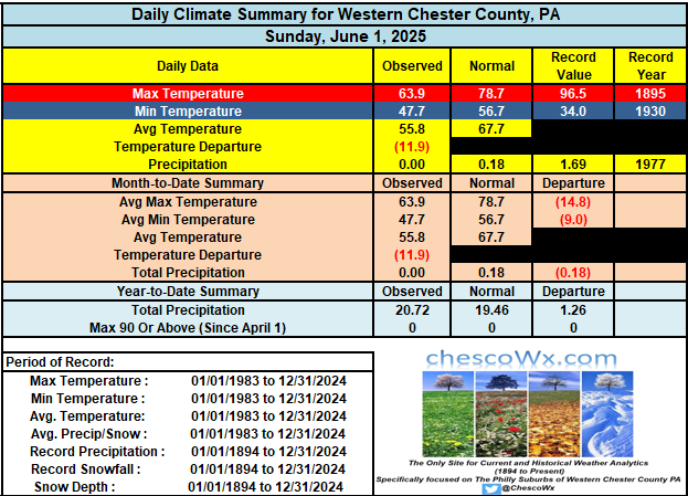
We had our 2nd straight morning with low temperatures in the 40's across much of the area. This is the first time since 2017 that we have seen back-to-back days with lows that chilly. Today will be our 15th below normal day over the last 16 days. The good news is we will finally warm back to normal tomorrow and then we will move several degrees above normal by Wednesday. The warmest day of the week should be Thursday with highs in the mid 80's across most of the Western Philly burbs. The Philly heat island should see their 1st 90+ day this week. Our next shower chances look to be by Friday PM into Saturday.

-

E PA/NJ/DE Summer 2025 Obs/Discussion
ChescoWx replied to Hurricane Agnes's topic in Philadelphia Region
We had our 2nd straight morning with low temperatures in the 40's across much of the area. This is the first time since 2017 that we have seen back-to-back days with lows that chilly. Today will be our 15th below normal day over the last 16 days. The good news is we will finally warm back to normal tomorrow and then we will move several degrees above normal by Wednesday. The warmest day of the week should be Thursday with highs in the mid 80's across most of the Western Philly burbs. The Philly heat island should see their 1st 90+ day this week. Our next shower chances look to be by Friday PM into Saturday.

- Today
-
Heat coming midweek. So it begins.
-

Central PA Spring 2025
Mount Joy Snowman replied to canderson's topic in Upstate New York/Pennsylvania
Low of 46. Summer arrives this week. -
38 degrees at my house in the Poconos this am. I saw a reading of 34 on my way to work on the truck thermometer, in a lower elevated sheltered area. Pretty impressive for June lol.
-
41! Good lord.
-
38 degrees at my house in the Poconos this am. I saw a reading of 34 on my way to work on the truck thermometer, in a lower elevated sheltered area. Pretty impressive for June lol.
-
Hopefully that front is further north for you guys. But like tip said, has that ALB to PSM look.
-
Records: Highs: EWR: 93 (2000) NYC: 96 (1895) LGA: 94 (1989) JFK: 91 (1961) Lows: EWR: 48 (1946) NYC: 48 (1946) LGA: 48 (1946) JFK: 51 (2015) Historical: 1889 - A great flood on the Potomac River in Washington D.C. took out a span of Long Bridge, and flooded streets near the river. The flood stage reached was not again equalled until 1936. (David Ludlum) 1889: The same storm that caused the historic dam failure in Johnstown, PA, also affected Washington, D.C. The streets and reservations in the center of the city and all the wharves and streets along the riverfront were under water. Pennsylvania Avenue was flooded from 2nd to 10th Streets. The Potomac River crested at the Aqueduct Bridge at 19.5 feet on June 2. Additionally, damage occurred on Rock Creek, with the Woodley Lane Bridge washed away. Considerable damage occurred to machinery plants and material at the Navy Yard. 1917 - The temperature at Tribune, KS dipped to 30 degrees to establish a state record for the month of June. (The Weather Channel) 1949 - A tornado northeast of Alfalfa OK circled an area one mile in radius. (The Weather Channel) 1985 - Lightning struck a house, broke a bedroom window, and jumped to a metal frame bed. A man was killed but his wife was unharmed by the lightning. (The Weather Channel) 1987 - Thunderstorms spawned seven tornadoes in West Texas and six tornadoes in Illinois. Thunderstorms in Illinois produced wind gusts to 70 mph at McComb and Mattoon. Thunderstorms in southern Texas produced 5.5 inches of rain south of Seguin, and up to eight inches of rain in Washington County. (Storm Data) (The National Weather Summary) 1988 - Severe thunderstorms in Texas and Oklahoma produced hail more than three inches in diameter near Stilwater OK, and softball size hail in Jones County of north central Texas. Baseball size hail and 70 mph winds caused an estimated 100 million dollars damage around Abilene TX. (National Weather Summary) (Storm Data) 1989 - Thunderstorms produced severe weather across much of the south central U.S. through most of the day and night. Thunderstorms spawned a dozen tornadoes, and there were 123 reports of large hail and damaging winds. Thunderstorm winds gusted to 78 mph at Russell KS, and baseball size hail was reported at Denver CO, Cuthbert TX, and in Reeves County TX. Afternoon thunderstorms in southern New England produced wind gusts to 120 mph at Fitchburg, MA, causing five million dollars damage. (The National Weather Summary) (Storm Data) 1998: Frostburg, Maryland on June 2, 1998, at 9:45 PM - This was part of a killer outbreak of tornadoes that moved southeast from Pennsylvania. The storm entered Garrett County, Maryland striking the town of Finzel. It then moved up and over Big Savage Mountain in Allegany County and ripped through the northern portion of Frostburg. It reached its peak strength as it crossed the ridge. Winds were estimated between 210 and 250 mph (F4 on the Fujita Tornado Damage Scale). This was the first tornado to "officially" be rated an "F4" in the State of Maryland. The National Weather Service adopted the Fujita Damage Scale in 1973. The total damage path of the Frostburg tornado was over 25 miles long (8 miles in Allegany County) and up to a half-mile wide. Along most of its path, it was producing winds over 125 mph (F2 or stronger). The damage path was continuous as it moved up and down over 2000-foot mountain ridges. The fact that no one was killed in Maryland was attributed to 5 to 10 minutes warning that was well communicated to people in Frostburg over television, radio, scanners, telephones, and sirens. People took quick action to move to their basements. A mother and child rode out the storm as it destroyed their house hiding under a table in the basement. They were shaken but unharmed. A jacket from a Frostburg home was found 25 miles away. A diploma was found near Winchester, Virginia, 60 miles away and a bill was found near Sterling Virginia (about 100 miles away). 2008: Several supercell thunderstorms rolled southeast from northwest South Dakota into central South Dakota, bringing large hail, damaging winds, and flash flooding during the late afternoon and evening hours. The large hail, up to baseball size, and high winds killed a large number of birds, pheasants, and rabbits. The large hail also knocked out many windows and damaged the siding of buildings and homes in both Stanley and Hughes counties. Very heavy rain of over 3 inches caused flash flooding in many parts of Pierre into the early morning hours. A Federal Disaster Declaration was issued for Hughes and Stanley Counties, mainly for the flooding. (Ref. Wilson Wx. History)
-
Last dry Saturday was 4/19. brutal.
-

2025-2026 ENSO
40/70 Benchmark replied to 40/70 Benchmark's topic in Weather Forecasting and Discussion
I think it's prudent to be skeptical, but I am willing to entertain it.....I just think its folly to speak in absolutes and act as if its a forgone conclusion.


.thumb.JPG.418e8a9a2902ae687ec35ff4bc0e038e.JPG)