All Activity
- Past hour
-
Yep called that yesterday. We suck
-
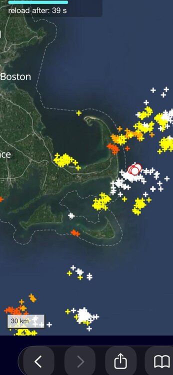
But Cape Cod!!!
-
Just brutal, 0.02” which is enough to dampen the pollen on the ground
-
7/10 baby. We knew
- Today
-

Texas 2026 Discussion/Observations
Stx_Thunder replied to Stx_Thunder's topic in Central/Western States
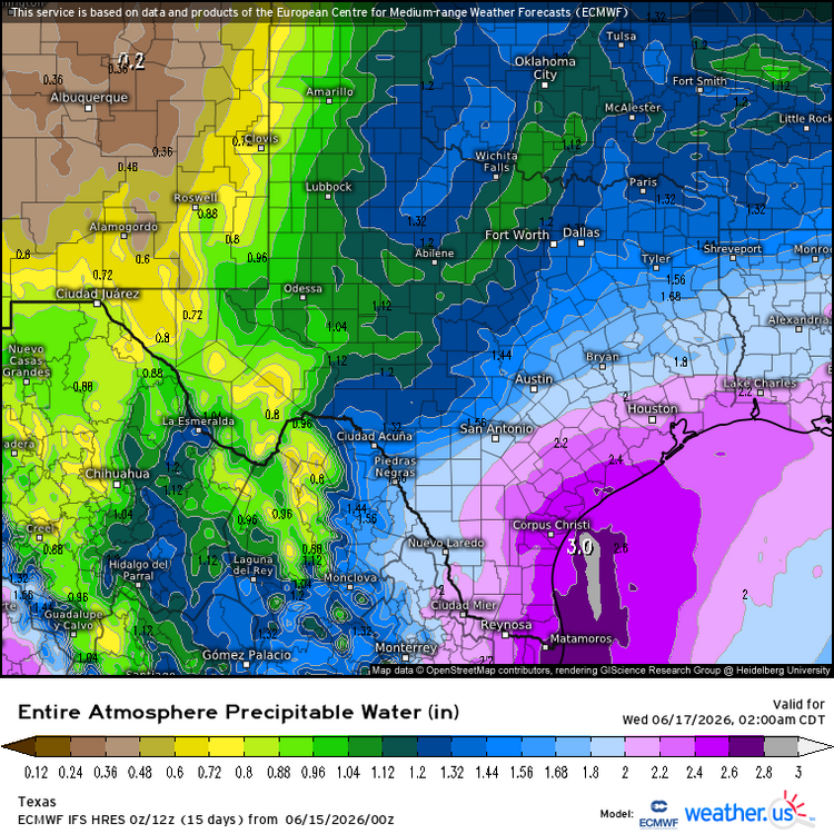
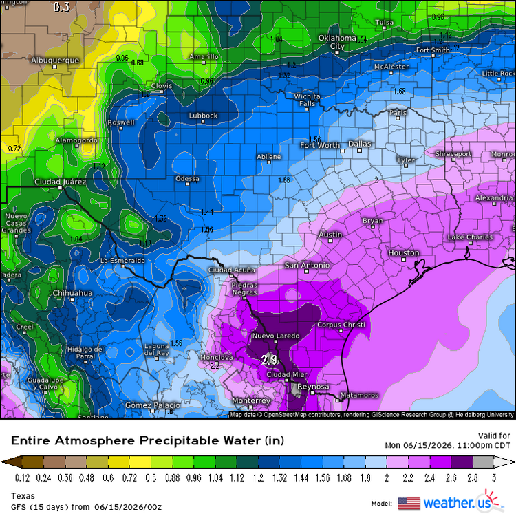
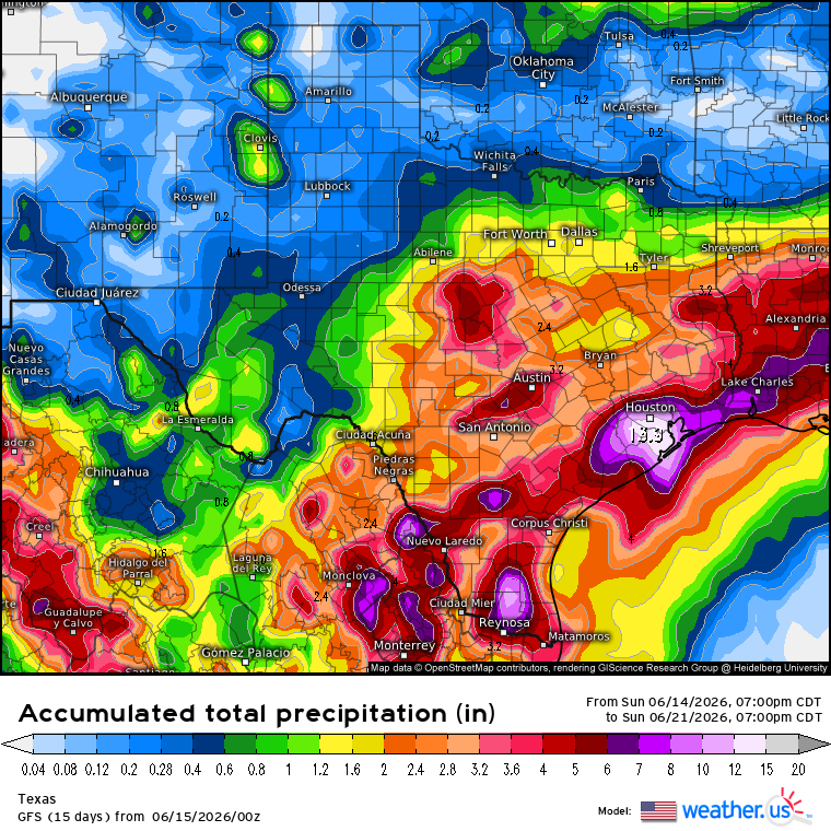
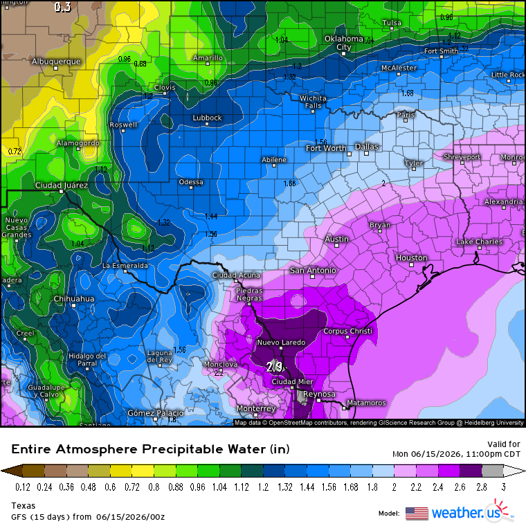
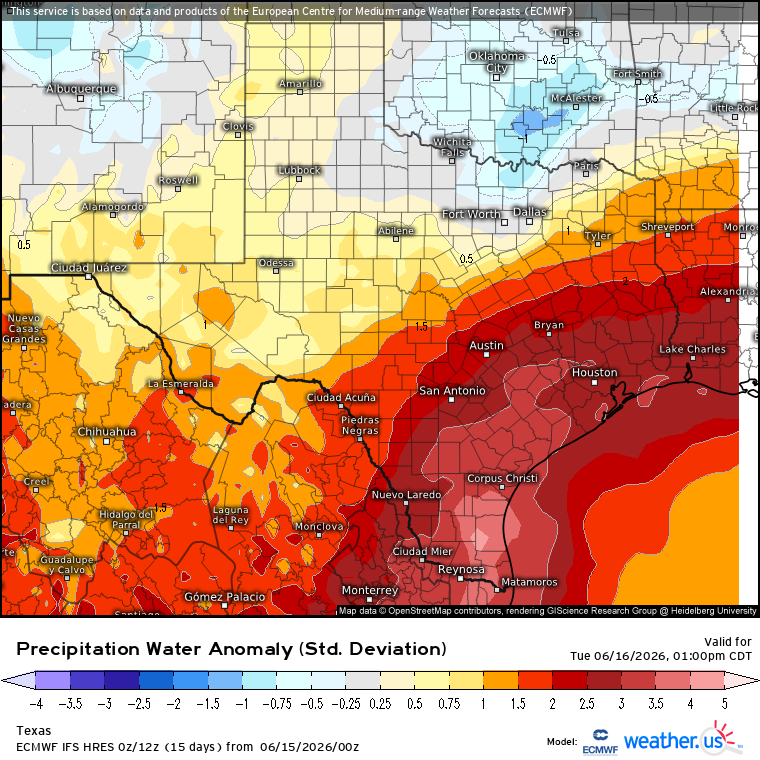
Very likely now to be wet with a W, over the Coastal region the next couple days from S-SETX. Significant flooding is almost a total guarantee due to a stalling front and the slow-moving, leftover circulation from what was TS Cristina (on Pacific side) of Central America earlier this past week. No disagreement on WPC's Moderate excessive rainfall risk area in STX (will likely get expanded east later today but could border on High risk with already saturated soils from late May heavy rainfall). Especially with Precipitable Water values extremely and 0 doubt, abnormally high for June standards (up to 3 in. Even along Lower Rio Grande!!!). There will be both, Gulf & Pacific moisture influx throughout most, if not entire troposphere. Euro has been very easily going over 10 inches on forecast accumulated total rainfall the past several days of runs. And going way higher now. Up to a whopping 30" in SETX on tonight's 0Z run. GFS is also catching up now (usually more conservative). Going over 10" on latest 0Z run tonight.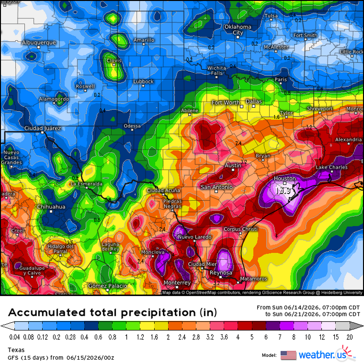

-
I will be satisfied with my paltry half inch of rain tonight. I don't mind drying up in Buda like the mayas of old. I actually love it. But what is getting my goat so damn bad tonight, is the fact that the NWS in their infinite wisdom placed a green Flood Warning box with the fucking boundary over my backyard. I do NOT get the privilege of actually BEING INCLUDED IN THE GREEN WARNING BOX. NEVER. Kerr Valley is going to get twelve inches overnight. No doubt about it. Yeah. I knew it. I am going to be missed by the storm cycle. Floods do NOT like Buda. I wish I lived in Cherrapunji, India. They get 1,050 inches of rain a year. HERE'S TO HOPING WITH ALL MY HEART, THAT THE FRONT STALLS RIGHT OVER MY BACKYARD IN BUDA, LADEN WITH HYPER-EFFICIENT TORRENTIAL SHOWERS! FOR DAYS. Yeah I am a sick pup. I wanna watch those water levels rise on Rt 1626 as Plum Creek rises about 35 feet Precipitable Waters are 2.4 inches overhead. Yeah this is slightly humid tropical air.
-

Arctic Sea Ice Extent, Area, and Volume
Stormchaserchuck1 replied to ORH_wxman's topic in Climate Change
Just haven't been able to get Summer Arctic ridging since the ice melt peak in 2012. 15 years is impressive for that record to hold, in this exponentially warming world. -
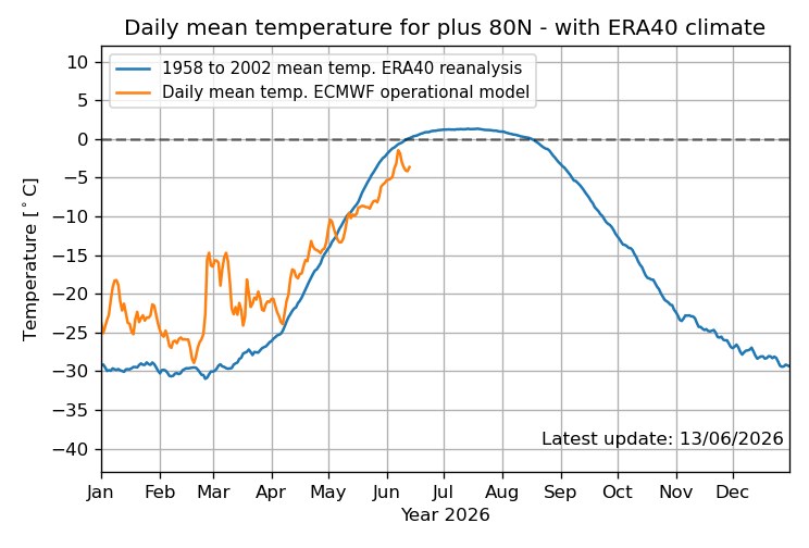
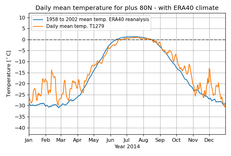
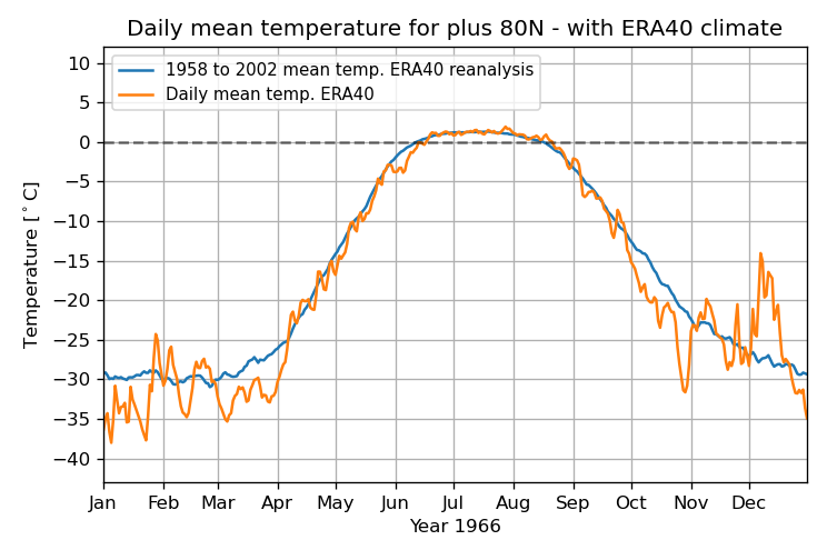
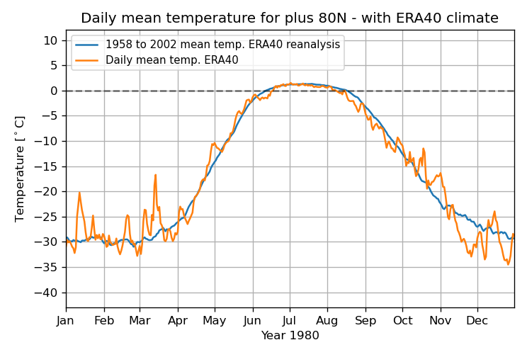
June MTD is by a good margin the coldest on record N of 80N! Furthermore, June 9-13th has averaged ~-4C, which is ~2C colder than what had been the coldest on record, 2014! Records go back to 1958! This is pretty surreal in our warming world: 2026 coldest for June 1-13 ~-3.5C and June 9-13 ~-4C! 2014 2nd coldest for June 1-13 ~-2.5C and June 9-13 ~-2C: 1966 3rd coldest for June 1-13 ~-2C: 1980 3rd coldest for June 9-13 ~-1.3C:
-

2026 Atlantic Hurricane Season
WxWatcher007 replied to Stormchaserchuck1's topic in Tropical Headquarters
I hadn’t thought of the severe implications, but that’s very interesting. Development odds have increased to 30% with the NHC. -
a few light showers roaming around. with no remotely close to interesting storms, rather let Stein reign supreme and burn
-
.82 and counting here, just had a nice rumble of thunder from the back end.
-
As expected it weakened and the heaviest missed to the south, but at least it was a decent band of steady moderate rain. Picked up 0.39" here so far. Enough to give the gardens a watering. I'm glad I won't have to water tomorrow, but obviously we need much more rain. Maybe something on Thursday, but the overall weather pattern continues to look dry. It's likely that this drought will continue to get worse.
-
I'm a snow weenie down by DCA and a severe weenie up in BOS. Who has it worse than me?
-
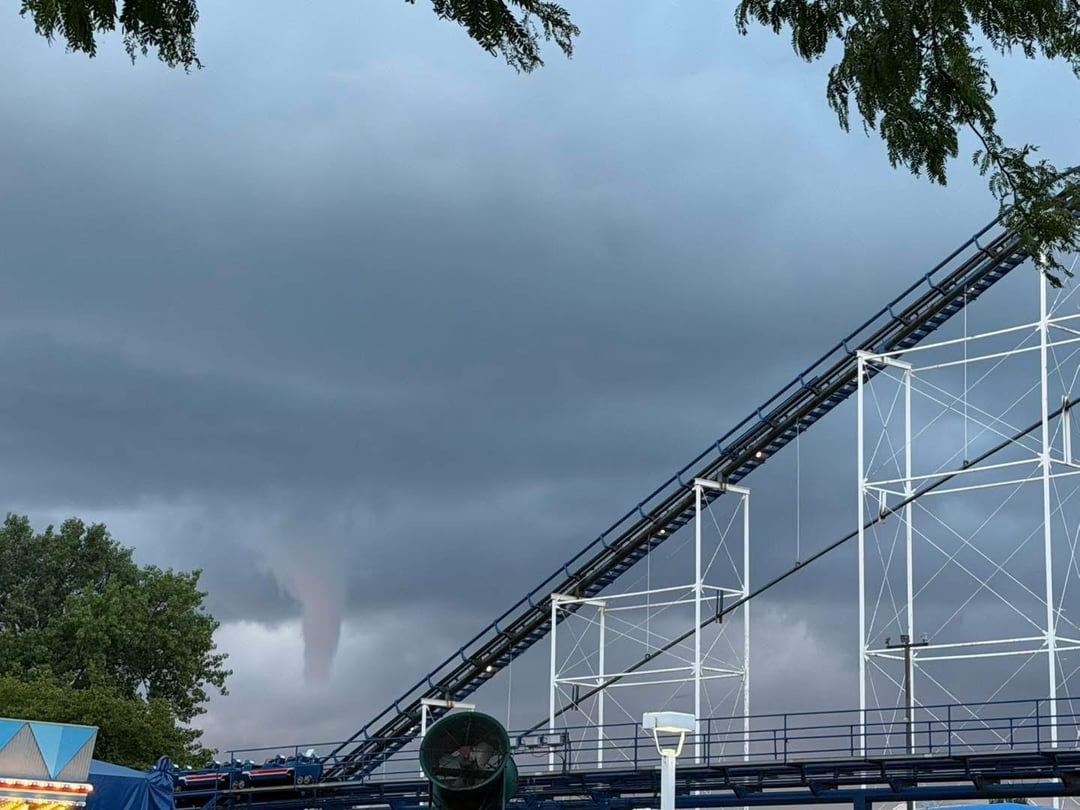
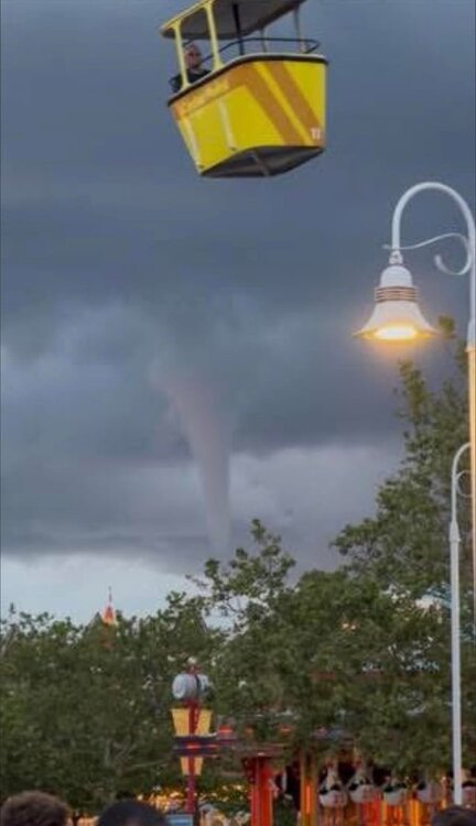
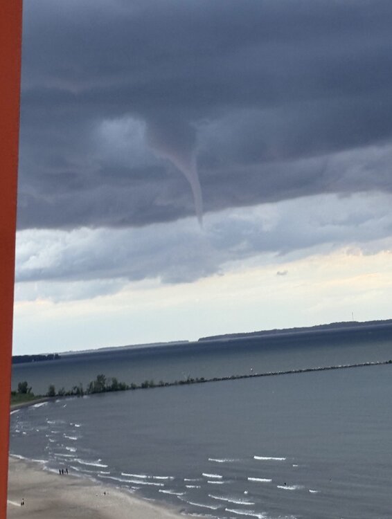
Water spout at Cedar Point

-
The low starts off as 995mb near Alberta then deepens and stays <990mb for the rest of its trek zonally across the continent. I take it that is highly unusual.
-
Am enjoying the app. The only one I have that gives me auditable storm warnings and lightning detected in my area with push notifications. Signed up as a yearly sustainer.
-

E PA/NJ/DE Summer 2026 Obs/Discussion
KamuSnow replied to PhiEaglesfan712's topic in Philadelphia Region
Wow, 2.75" here as it seems to be winding down. Didn't expect that. 72°F currently. -
0.01” just now.
-
GFS seems to want to bring the WF into the Metro.
-
Congrats Carolina! I had them picked to win the Cup from game one. That usually NEVER happens, but I had a feeling it was their year, and it was.
-
I'm not even really sure how to process this potential day-4 threat (Wednesday.) The 500mb jet streak is much stronger than average, surface low pressure is lower than most pressure I've seen in June, other than hurricanes.
-
Got a good one here. Rainfall rates up to 6.83 inches per hour. Total rainfall was 1.85
-
Moderate rain now with a few flashes of lightning and rumbles of thunder. Radar looks pretty solid. Hopefully we get at least half an inch from this
-
I've seen some "regular" E TX/LA storms that easily rival the best I have seen in NE. If you enjoy snow and highest end severe, IA/NE life probably the best call
-

2026 Atlantic Hurricane Season
vortex95 replied to Stormchaserchuck1's topic in Tropical Headquarters
Glad you pointed this out. ECMWF was unrealistically showing tropical deepening well inland from MS to the Carolinas. 18z backed off and looks more reasonable. And now the GFS has the same idea. Excellent point about how this may play a role in the SVR later in the week. It seems up until now, rich deep moisture was lacking as noted by not so high CAPE even in the Mid-Atlantic, but this tropical low could make a huge difference as to sensible svr wx, esp. NYC to DCA.


.thumb.gif.f92b16c631a1d15d405ed77b33f0710d.gif)