All Activity
- Past hour
-
Started most of my veggie plants back in early April inside where I have a small grow room. There's something very satisfying about watching a plant sprout and grow when there's still 4' of snow otg. Annual flowers and a few other things I purchase from a greenhouse in Negaunee where I work each summer. Of course, I planted most everything yesterday when the forecasted low for last night was 44, but it was one of those sneaky cold nights I worry about, with an actual low of 37 here. Thankfully I covered everything with a frost cloth to be safe. Two more night of lows in the mid 40's then the nights begin to slowly warm. Sun and mid 70's today. Have only had .75 inches of rain for the month. Pollen is thick on everything. Leaf out is about 60-70% on most trees w/ the exception of the oaks which always lag behind.
-
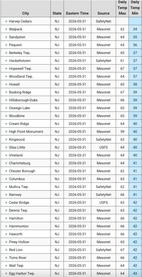
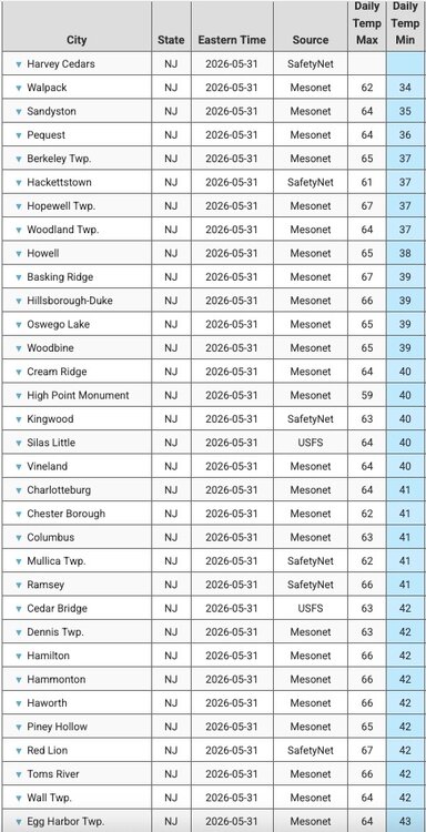
Sampling of lowest mins across NJ this morning. Low of 43 here. So great to still be sleeping with the windows open. Back to a drier pattern again. Not much rain in sight next 7 to maybe 10 days. Thankfully no big heat either.
-

2026-2027 Strong/Super El Nino
GaWx replied to Stormchaserchuck1's topic in Weather Forecasting and Discussion
I’ve noticed that there’s a significant number especially in the northern U.S. here and at other wx bbs who like cold only for snow chances and otherwise prefer mild in winter. They hate cold and dry, complain about it being “useless cold”, and prefer mild if it’s not going to snow. The good news with very strong El Niño winters is that there’s typically not as much cold, dry wx as in other winters. There will generally be a few significant to possibly major snowstorms but otherwise lots of mild for those folks to enjoy. I always prefer cold but I’m deep in the SE US and thus cold here isn’t typically that cold up north. If I were living up north, I’d probably have a different take on my desire for cold and would enjoy mild periods much more as mild up there is not nearly as warm as down here and too much and too severe cold would get tiring fast. -
Thanks for the clarification. Interesting that the low occurred so early in the night. .
-
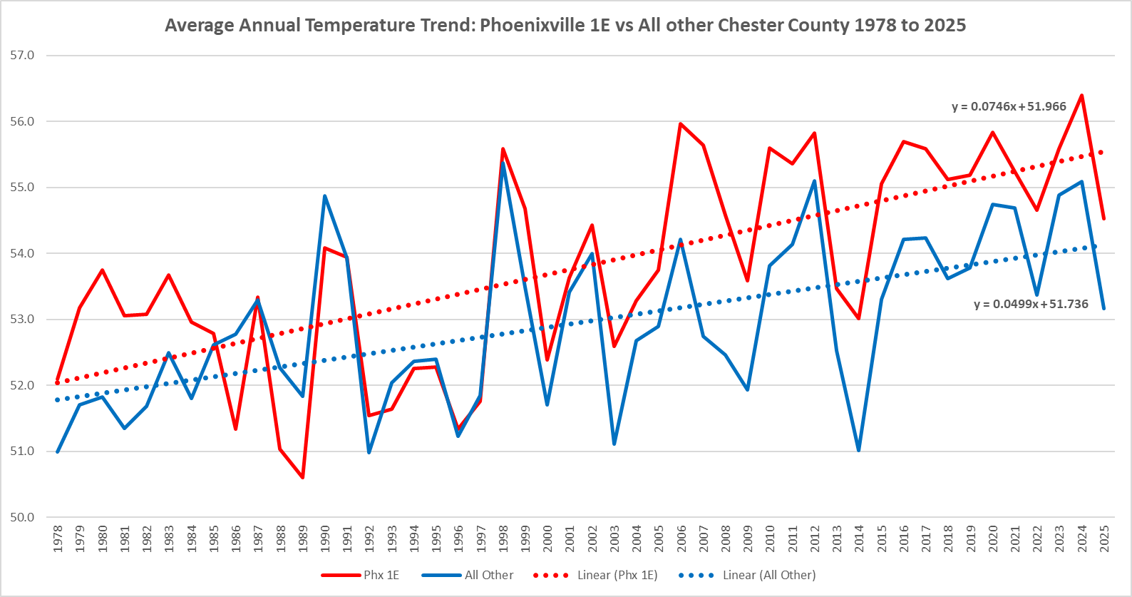
(002).thumb.png.6e3d9d46bca5fe41aab7a74871dd8af8.png) But of course during that 1978 to 2025 period Phoenixville 1E is warming at almost a 50% faster rate than the rest of Chester County. The Phoenixville area is about as least representative of the entire county with the vast majority of Chesco lying at over 450ft above sea level
But of course during that 1978 to 2025 period Phoenixville 1E is warming at almost a 50% faster rate than the rest of Chester County. The Phoenixville area is about as least representative of the entire county with the vast majority of Chesco lying at over 450ft above sea level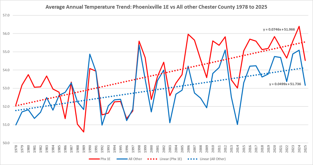
-
Going to be interesting to see if Upton's forecast of Mostly Sunny verifies as we head into the afternoon hours
-
Not everybody got in on the same level of action but that’s tropical. Not taking anything away from the eastern New England area that got rocked. Approaching 35 years without a strike now…
-

Central PA Spring 2026 Discussion/Obs Thread
Voyager replied to Voyager's topic in Upstate New York/Pennsylvania
I thought it wasn't supposed to be windy today. Forecast is for calm to 5mph, but it's still quite breezy here this morning. -

Central PA Spring 2026 Discussion/Obs Thread
Jns2183 replied to Voyager's topic in Upstate New York/Pennsylvania
Groundwater is a different animal to all of those things. You need to ask yourself what you are measuring because your measuring different things. There's things like river gauge level for things you want to measure. Sent from my SM-S731U using Tapatalk -
Down to 36.4° at WXW1. That’s damn impressive for late May here.
-
Gotta love statistics…. Mark Twain having a laugh. Gorgeous out; enjoy the day all!
-

2026-2027 Strong/Super El Nino
WX-PA replied to Stormchaserchuck1's topic in Weather Forecasting and Discussion
97-98 the coast got shut out but inland didn't do that bad..we had a dusting of snow a few days after Christmas..it was warm like all Super Nino's are. 82-83 had a snow event in middle of December..65 degrees Chistmas day and a blizzard in February..15-6 had a blowtorch December..70 degrees Christmas day and a historic blizzard 4 weeks later..So yes it will be warm but there will be winter weather. -
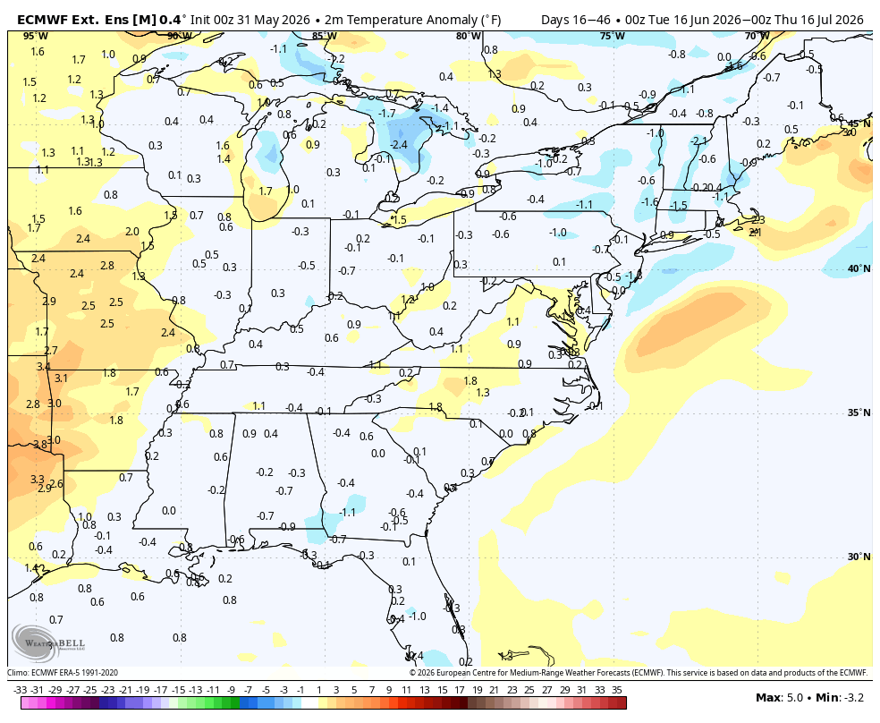
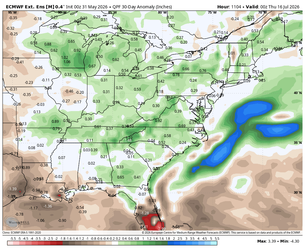
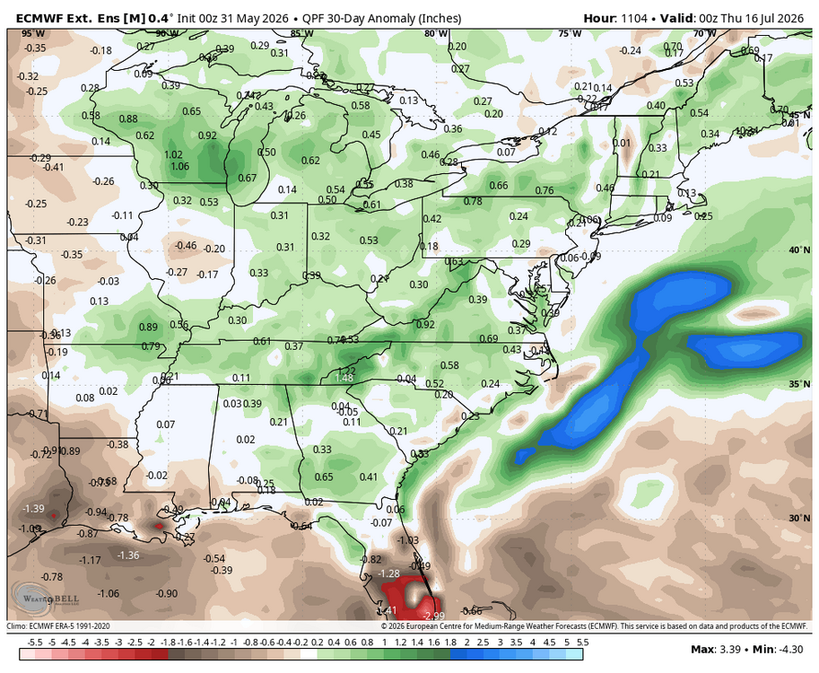
 WB latest Euro weeklies for mid June to mid July. Amazing how fast time flies already posting thru mid summer...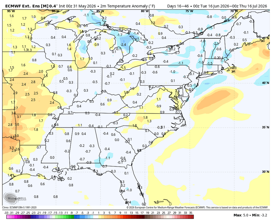
-
Central PA Spring 2026 Discussion/Obs Thread
ChescoWx replied to Voyager's topic in Upstate New York/Pennsylvania
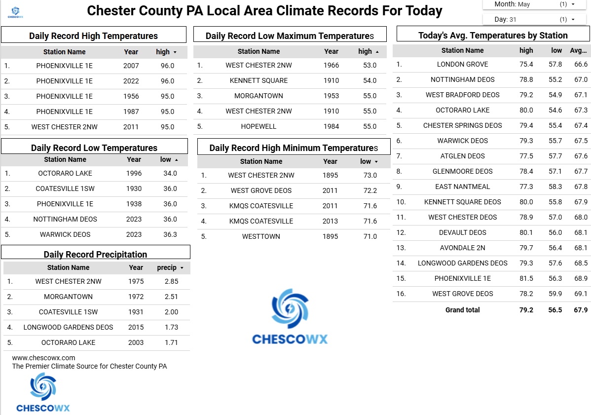
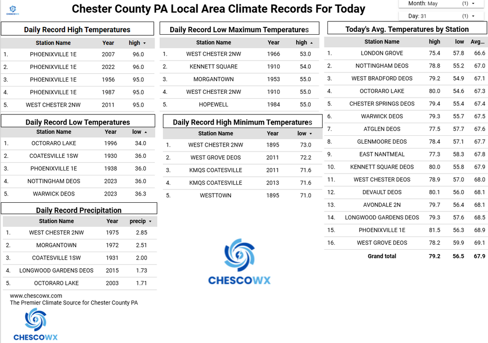
Lows this morning were not too far from record cold levels for the final day of May. The lowest was the 38-degree reading at Warwick Township. During our last 37 days we have seen 26 of those days with below normal temperatures here in East Nantmeal. This pattern looks to it will continue through mid-week before we finally see temperatures warming to above normal by the end of the work week. Unfortunately there is no rain in site.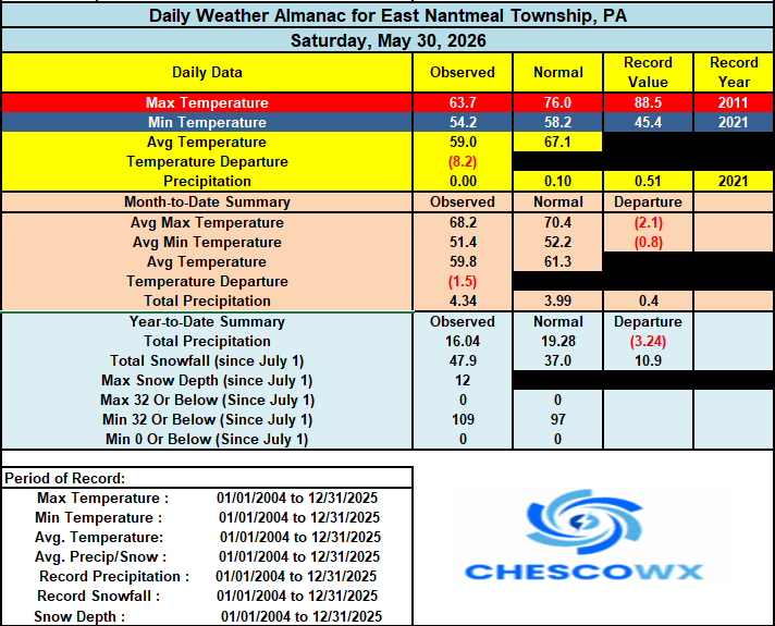
-
E PA/NJ/DE Spring 2026 Obs/Discussion
ChescoWx replied to PhiEaglesfan712's topic in Philadelphia Region
Lows this morning were not too far from record cold levels for the final day of May. The lowest was the 38-degree reading at Warwick Township. During our last 37 days we have seen 26 of those days with below normal temperatures here in East Nantmeal. This pattern looks to it will continue through mid-week before we finally see temperatures warming to above normal by the end of the work week. Unfortunately there is no rain in site.
-
 June DCA _ NYC _ BOS _ ORD _ ATL _ IAH _ DEN _ PHX _ SEA 1.5 1.3 1.3 2.2 0.5 0.1 2.4 2.2 1.5 103 99 99 100 98 105 100 117 94
 -
Just solidifies my belief that when I retire, I need to go south from about March 15 until June 1st.
-
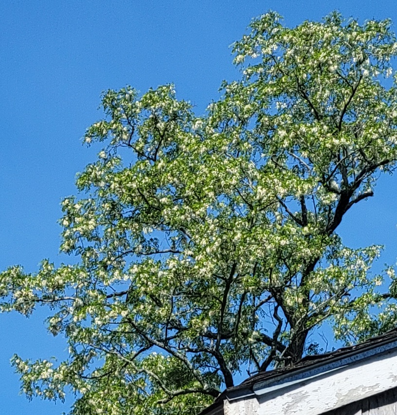
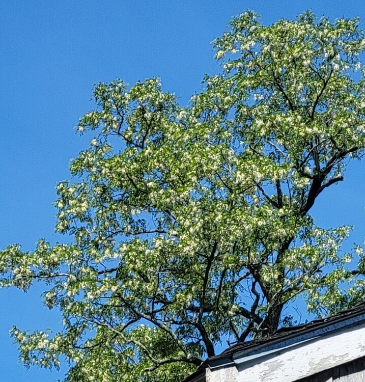
Nice morning so far. Hope to get a couple more hours out of it. Black locust finally blossoming. Last of the trees.
-

2026-2027 Strong/Super El Nino
rclab replied to Stormchaserchuck1's topic in Weather Forecasting and Discussion
83% of the warmest temperature winters (40+ degrees) occurred in the last 26 years. What saddens me is if I make it to my hoped for 104th birthday in 2051, the entire list may consist of 21st century years. As always ….. - Today
-
That occurred before 1 am EDT, so it was counted as yesterday's low. Records are based on standard time.
-
Records: Highs: EWR: 98 (2022) NYC: 96 (1939) LGA: 96 (1987) JFK: 94 (2022) Lows: EWR: 44 (1938) NYC: 46 (1938) LGA: 50 (2021) JFK: 48 (2023/2021) Historical: 1830: Shelbyville, Tennessee was turned into "a heap of ruins" as a tornado moved east through the center of the town. This tornado destroyed 15 homes and 38 businesses along with churches and other public buildings. Losses were estimated to be as high as $100,000. A book was said to be carried seven miles away. 1858: A tornado moved across Warren County and devastated the town of Ellison, IL about 14 miles southwest of Monmouth. Only 3 cabins were left standing. 19 people were killed, and 60 injured, along the tornado's 5 mile long track. (Ref. Wilson Wx. History) 1889 - The Johnstown disaster occurred, the worst flood tragedy in U.S. history. Heavy rains collapsed the South Fork Dam sending a thirty foot wall of water rushing down the already flooded Conemaugh Valley. The wall of water, traveling as fast as twenty-two feet per second, swept away all structures, objects and people. 2100 persons perished in the flood. (David Ludlum) 1927: Springtime of 1927 saw 18.64 inches of rain fall in the Peoria, IL area. This established their wettest Meteorological Spring (March, April, May period) on record. (Ref. Wilson Wx. History) 1934: Early season heat gripped central Illinois. Springfield reported its earliest triple-digit high temperature on record, with a temperature of 101°. (Ref. Wilson Wx. History) 1941 - Thunderstorms deluged Burlington KS with 12.59 inches of rain to establish a 24 hour rainfall record for the state. (The Weather Channel) 1954: Sioux Falls, SD recorded their latest snowfall on this date when a half inch was reported. (Ref. Wilson Wx. History) 1961 : Boston, MA suburbs experience a late freeze. (Ref. NOAA Boston Weather Events) 1983: Albany, NY experienced its wettest spring season in 109 years of records with 19.54 inches while Philadelphia, PA also had their wettest spring with 21.85 inches of precipitation. (Ref. Wilson Wx. History) 1985 - Severe thuunderstorms spawned forty-one tornadoes across the Lower Great Lakes Region and southeastern Ontario which killed 74 persons. (Storm Data) 1987 - Thunderstorms in New England produced wind gusts up to 90 mph at Worcester, MA, and Northboro, MA, and hail an inch and a half in diameter at Williston, VT. Unseasonably hot weather prevailed in the northeastern U.S. The afternoon high of 94 degrees at Portland, ME, was a record for the month of May. (Storm Data) (The National Weather Summary) 1988 - Hot and humid weather prevailed in the eastern U.S. Thirteen cities reported record high temperatures for the date. Cape Hatteras, NC, reported their first ninety degree day in May in 115 years of records. "Dust buster" thunderstorms in northwest Texas drenched Amarillo with more than three inches of rain. (The National Weather Summary) 1989 - Thunderstorms produced severe weather and torrential rains in northern Indiana, northern Ohio and southern Lower Michigan. Saint John IND was drenched with four inches of rain in two hours, and Woodland MI was deluged with two inches in twenty minutes. Pittsburgh PA reported a record 6.55 inches of rain for the month of May, with measurable rain reported on twenty-five days during the month. (The National Weather Summary) 1990 - Afternoon and evening thunderstorms developing along a warm front produced severe weather from northwest Texas to southeastern Louisiana. The thunderstorms spawned sixteen tornadoes, including thirteen in northwest Texas. One tornado hit the town of Spearman, TX, causing more than a million dollars damage, and seven other tornadoes were reported within twenty-five miles of Spearman. Thunderstorms over northwest Texas also produced baseball size hail at Monahans, and wind gusts to 80 mph at Paducah. (The National Weather Summary) (Storm Data) 1991: May record seven consecutive 90°+ days-- DC May's record high temperature 99°, low 78° are both all time highs for May. Norfolk, VA hit 100° setting a new all-time record high for the month of May and Philadelphia, PA hit 97° tying their May record high set the previous day. This was the warmest May on record in Washington, D.C. The city also observed a record 11 days of 90-degree heat. (Ref. Wilson Wx. History) 1992: This May was the driest on record for Chicago, IL and Rockford, IL. Only 0.30 inches of rain fell at Chicago and Rockford had a paltry 0.48 inches. The total rainfall at El Paso, TX of this past month was 4.22 inches, making this the wettest May ever for the city. The normal rainfall for May is only 0.24 inches, which means that this month's rainfall total was 1,758% of normal. (Ref. Wilson Wx. History) 1995: The U.S. set a new monthly tornado record in May, 1995 with 408 twisters reported. The record would be surpassed in the busy month of May 2003, when over 500 twisters were reported. (Ref. Wilson Wx. History) 1997: Mount Washington, NH recorded 95.8 inches of snow for the month which exceeded the previous May snowfall record by 43.6 inches. (Ref. Wilson Wx. History) 1997: Mount Washington, NH recorded 95.8 inches of snow for the month which exceeded the previous May snowfall record by 43.6 inches. (Ref. Wilson Wx. History) 2001: Death Valley National Park, CA recorded a high temperature of 118°, setting a daily record. (Ref. Wilson Wx. History) 2003: The average maximum temperature for May had a -7.32°F departure and was the coldest May on my 23-years of records. Baltimore BWI said May 2003 was the third coldest in the last 130 years! Annandale Weather Center listed May as the cloudiest May on record and the second cloudiest month in the last 23-years. Only November 1986 was cloudier and not by much. May also had 23 days with measurable precipitation the most ever recorded for any month. The old record was only 19 day in June of 1998. (Ref. Annandale Hills Weather Center) 2011: The Richmond area had its warmest spring and the eighth-warmest May on record. Figures released by the National Weather Service in Wakefield on Friday show the average temperature from March through May was 62.4 degrees. That breaks the mark of 61.5 degrees set for the three months in 2010. (Ref. Ref. NBC 12 News, Weather & NWS) (Ref. NWS & West Henrico Co. - Glen Allen Center) 2013: The 2nd of the top 10 weather events for 2013 was EL Reno, Oklahoma tornado of May 31, 2013. Part of the multi-day storm outbreak caused $2 billion in damage. The EF3 that traveled through the western suburbs of Oklahoma City was the largest tornado ever observed with a width of 2.6 miles. It took eight lives including four tornado chasers.
-
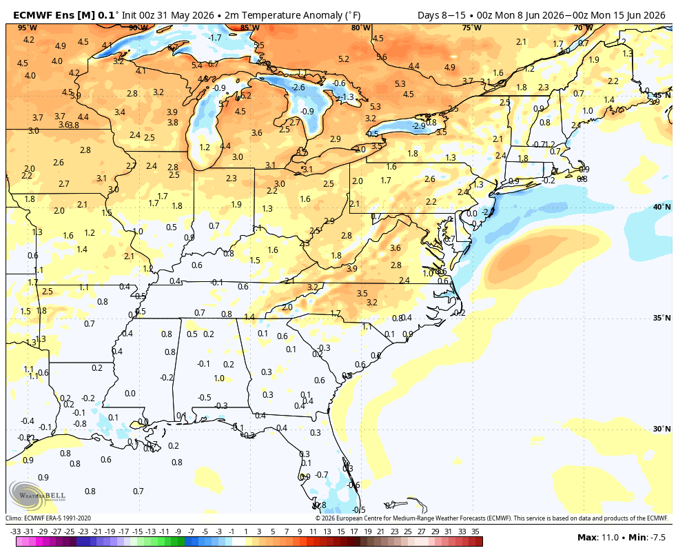
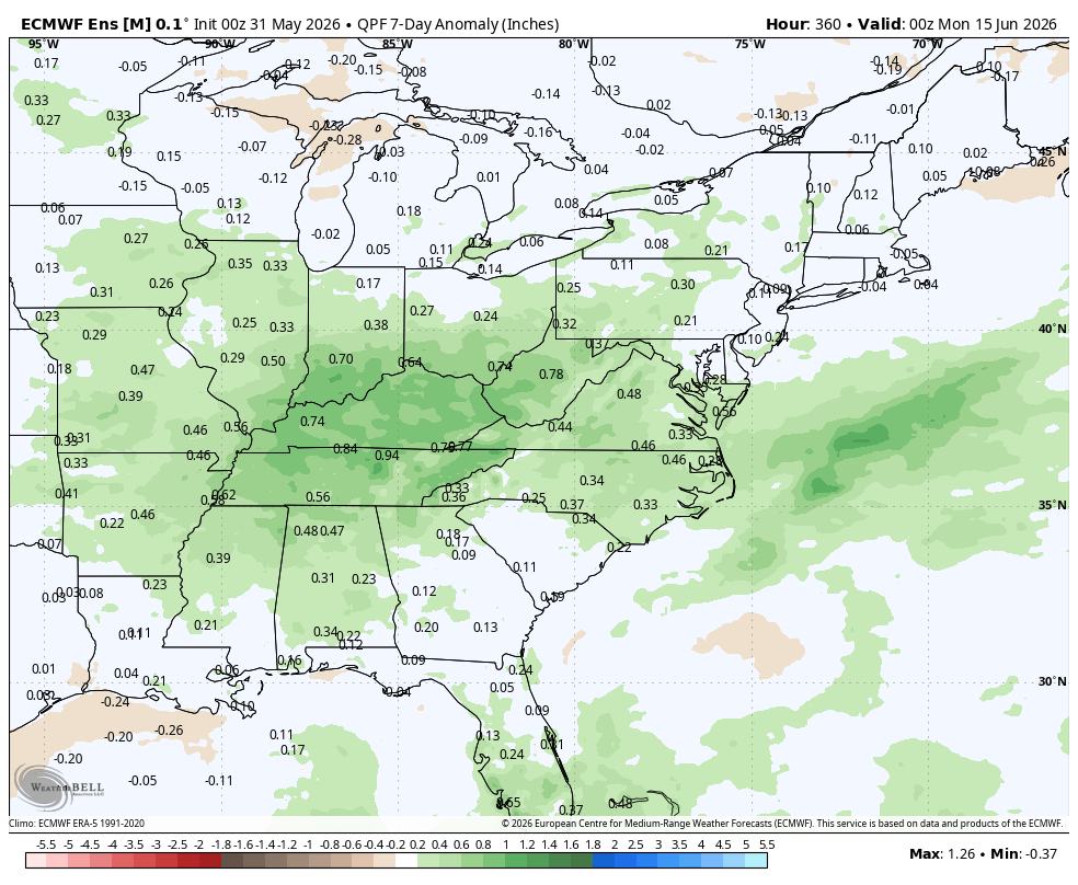
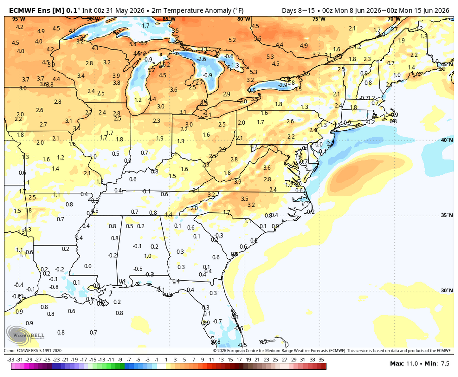
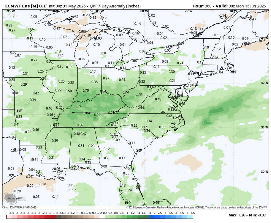
WB 0Z EPS for 2nd week of June. Summer returns with above normal temps. Precipitation normal to slightly above.
-
Down to 40 here now 63 / 42. A gorgeous day ahead mid 70s to low 80s as the ULL out to see and overall yesterday wasnt half bad. Near normal / dry week balanced by a cooler Mon/Tue and warm to potentially sneaky heat Thu - Fri. Overall normal to above once to the 4th and beyond. Core of the highest departures remain to the north and west with flow flattening a bit - more ridging / sustained warmth second week of June.
-
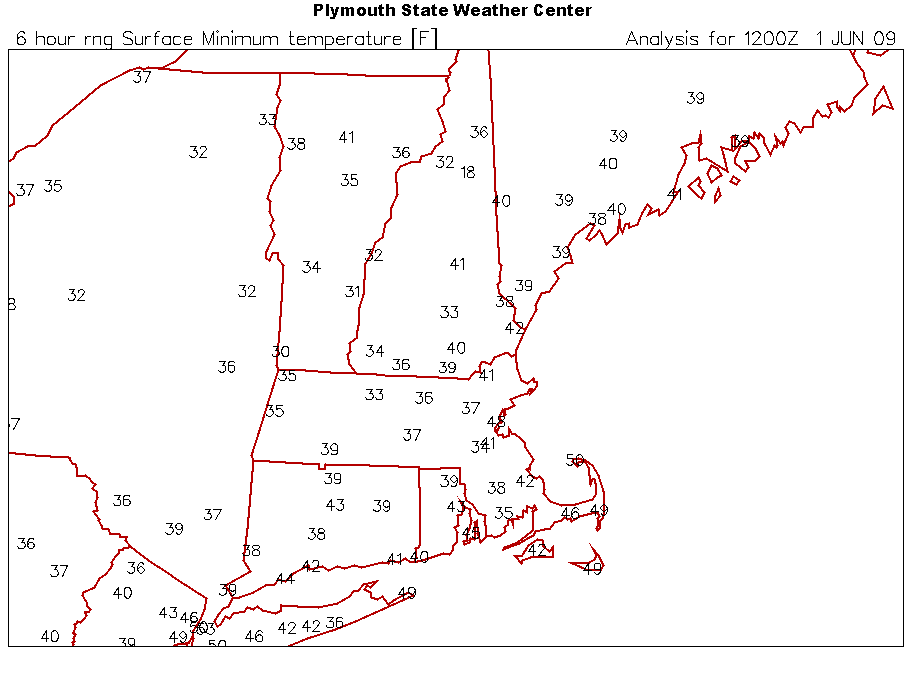
6/1/09 we had legit frost here. FIT was 1F cooler than this morn. So maybe then?