All Activity
- Past hour
-

Possible coastal storm centered on Feb 1 2026.
Ginx snewx replied to Typhoon Tip's topic in New England
Let's get that Bahamas low to scoot out -

The Jan 31 Potential: Stormtracker Failure or 'Tracker Trouncing
Nomz replied to stormtracker's topic in Mid Atlantic
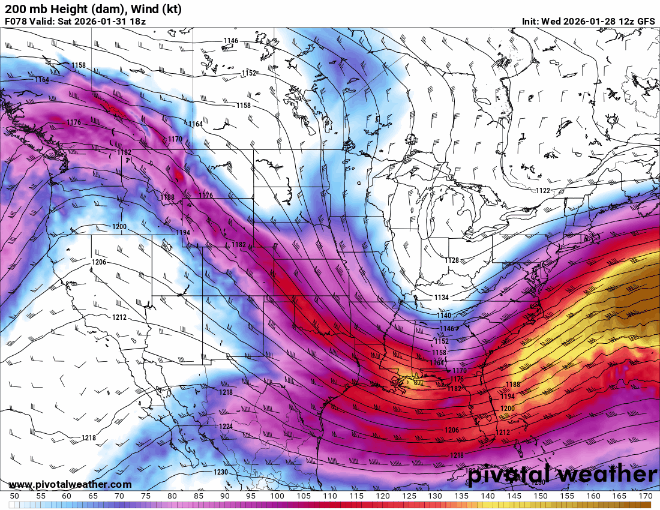
GFS at f78 is now less negative than even the euro. Pack it up folks. -

E PA/NJ/DE Winter 2025-26 Obs/Discussion
Chadzachadam replied to LVblizzard's topic in Philadelphia Region
NBM throws a few inches back towards Philly on Sunday and has most of South Jersey with over 6" I do think we likely end up with something here, Lehigh Valley might be out of luck but Philly and immediate burbs have a decent chance -
Missed South...missed North...now looks like missing east! I'd take a dusting and be happy with this one.
-
She gone
-

Richmond Metro/Hampton Roads Area Discussion
Ephesians2 replied to RIC Airport's topic in Mid Atlantic
at 78h on the 18z GFS: more progressive and south of 12z clear step back -
Possible coastal storm centered on Feb 1 2026.
Ginx snewx replied to Typhoon Tip's topic in New England
Or until the 18z Euro pulls us back in. -

The Jan 31 Potential: Stormtracker Failure or 'Tracker Trouncing
paulythegun replied to stormtracker's topic in Mid Atlantic
Need to use the Tropical Atlantic view to really understand what GFS is doing at the surface. It's offscreen on the CONUS view. -
I really hate Miller A’s. Feast or famon and more often than not, the latter.
-

February 2026 Medium/ Long Range Discussion: Buckle Up!
LongRanger replied to Weather Will's topic in Mid Atlantic
fwiw, during the cold winters of the '70s, the longwave pattern shifted as spring neared such that we flipped to the warm side -

Possible coastal storm centered on Feb 1 2026.
Damage In Tolland replied to Typhoon Tip's topic in New England
It’s only the gfs . Absolutely no concern -

The “I bring the mojo” Jan 30-Feb 1 potential winter storm
neverSnowsLCSC replied to lilj4425's topic in Southeastern States
How similar to the early January 2018 storm is this looking to be? -

Possible coastal storm centered on Feb 1 2026.
RUNNAWAYICEBERG replied to Typhoon Tip's topic in New England
Save a pony, they will say. -
 Did everything just shift SE? Wow
 -

The “I bring the mojo” Jan 30-Feb 1 potential winter storm
PackGrad05 replied to lilj4425's topic in Southeastern States
That was an objective fact based on their model run. There was no opinion or subjectivity paired with it. -
Better, way up there ...
-

The “I bring the mojo” Jan 30-Feb 1 potential winter storm
Regan replied to lilj4425's topic in Southeastern States
Their futurecast graphics blow. -

1-30/2-1-26 Arctic Blast, ULL Snow Event
tnweathernut replied to John1122's topic in Tennessee Valley
The 18z NBM increased totals from Knoxville and points east and has been beefing up the last several runs, FWIW -

Possible coastal storm centered on Feb 1 2026.
ORH_wxman replied to Typhoon Tip's topic in New England
00z is last stand I think...we need a trend back west at 00z or we can punt this one I think. This is the type of threat that 2 or 3 east trends in a row is fatal. -

The “I bring the mojo” Jan 30-Feb 1 potential winter storm
StantonParkHoya replied to lilj4425's topic in Southeastern States
You are truly insufferable . -

The “I bring the mojo” Jan 30-Feb 1 potential winter storm
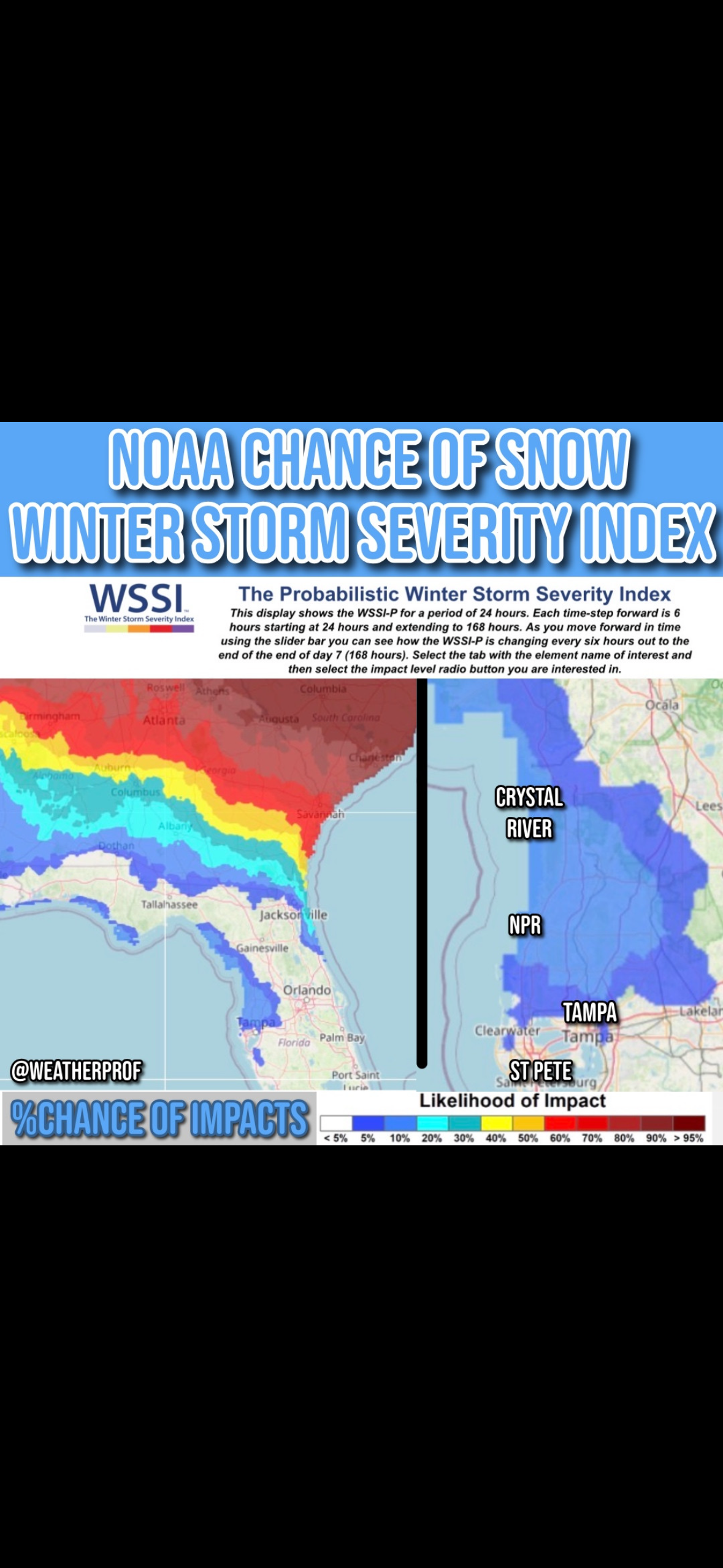
TPAwx replied to lilj4425's topic in Southeastern States
Unlikely but it’s a feasible set up. Last snowfall here was 1977.
-

E PA/NJ/DE Winter 2025-26 Obs/Discussion
Violentweatherfan replied to LVblizzard's topic in Philadelphia Region
What are your thoughts regarding the possibility of cutbacks (lack of funding) to NOAA/NWS impacting model data early on and then getting better sampling later. Therefore odd model solutions -
 GFS finally catching on that this is not our storm!
 -

The “I bring the mojo” Jan 30-Feb 1 potential winter storm
olafminesaw replied to lilj4425's topic in Southeastern States
GFS a touch flatter. No surprise, as guidance begins to tighten up -

Richmond Metro/Hampton Roads Area Discussion
overcautionisbad replied to RIC Airport's topic in Mid Atlantic
Weird. Has snow shower putting an inch in Richmond on Friday Looks like less moisture. No good for Richmond at all. GFS has caved to Euro looks like