All Activity
- Past hour
-
If we have westerly winds sure. When you see the low heights to our NE this time of year though we all know what that means.
-
Very true. Refuse to Lose was an awesome time. I knew the entire starting lineup as a 13 year old, and I can't remember anything like it since in this area.
-
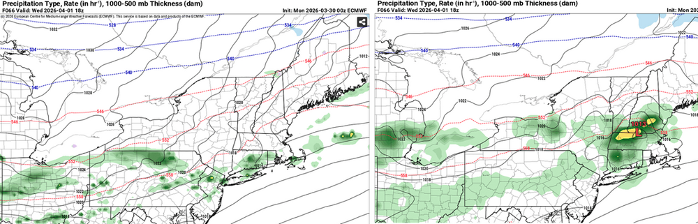
Weird to see the Euro 60 hours ( 00z ) be so differently designed than the GFS. I did notice that the last 6 consecutive cycles of the the guidance have en mass/average been raising heights a tick or two...Now 582 dm over Logan ..versus 573 for this mid week's period from just a day or so ago. The Euro appears to be conceding to that with a frontal wave in NNE and Wed am warm sector ...front comes thru noon-ish but weak backside CAA in intense April sun, d-slope under lingering 850s in the +6 or 7 range... that's a decidedly different implication than the GFS. The Euro might actually be a better fit for that tendency to raise heights with the ridging/582. I guess in the strict Meteorological techy shit it's not that hugely different, but the sensible weather implication is really where the differences lie - and "lie" may be the best fit. Ha. Verbatim, this GFS (right) is orange lightning slow growl rumbler rains with chilly air undercutting into NE zones. We where mild so capped temperatures SW and basically ... blegh. The Euro on the other hand is probably 75 F with partliy sunny. Over all, there was less cold undercutting total synoptic implications across all guidance... Slightly but perhaps crucially less aggressive in that regard. I think I speak for the majority at this point, we hope so.
-
alot of it will miss to our NW however-SE ridge flexing
-

It's time to grade Winter 2025-26(now that it's actually over)
GramaxRefugee replied to CAPE's topic in Mid Atlantic
(Enjoyed reading everyone's grading and explanations) A- The criteria, (In chronological order. Not all items are equally weighted): 1. White Christmas: Fail; but significant December snow and BN cold softens this greatly 2. AN snowfall: Success; but not by a whole lot. 3. at least one MECS: Fail; but with a major snowfall in Jan which was close. Tough call here. 4. Just plain cold: Success. BN for each month of DJF. Don't have a thermometer? Just observe the tidewater and freshwater both. Fast ice for a month +/-. I have made a crude chart below of DJF Temp Avg at BWI since 1950, and this year was 14th coldest out of the 75 years. Anomaly not listed, but roughly -3f for each month. Sorted by Average; the usual suspects are on top. (Apologies for my XL skills) YEAR JAN FEB Previous DEC DJF AVG 1963 28.7 27.7 30.9 29.1 1977 22.9 36.5 32.6 30.7 1978 29.2 27.3 35.6 30.7 2003 28.3 30.2 34.3 30.9 1961 27.6 37.0 28.4 31.0 1964 33.8 33.2 28.7 31.9 1982 25.5 35.8 34.5 31.9 2015 30.8 25.3 39.9 32.0 1994 27.0 34.0 36.2 32.4 1959 32.0 35.7 29.9 32.5 1962 32.4 32.3 33.4 32.7 1970 27.8 35.4 35.2 32.8 2010 32.7 30.9 34.8 32.8 2026 30.5 33.7 M M M M M M M M 34.2 32.8 1966 29.8 30.5 38.3 32.9 1968 29.2 32.1 37.3 32.9 1979 33.1 25.5 40.1 32.9 2004 27.6 34.8 36.4 32.9 1986 33.1 32.9 33.7 33.2 2014 27.4 32.9 39.6 33.3 1958 32.4 28.9 39.1 33.5 2011 30.2 38.5 32.4 33.7 1969 31.7 34.9 34.6 33.7 1996 31.7 35.7 33.9 33.8 2001 33.0 38.5 30.0 33.8 1955 32.3 34.4 35.0 33.9 1981 27.9 38.8 35.5 34.1 1956 32.6 38.7 31.3 34.2 1984 28.5 41.7 33.2 34.5 1967 37.4 30.7 35.6 34.6 1988 28.6 35.8 39.8 34.7 1965 30.7 34.9 39.0 34.9 1987 32.4 34.3 38.1 34.9 2009 29.3 37.4 38.5 35.1 1980 33.8 31.4 40.3 35.2 1971 30.0 37.4 38.2 35.2 2025 30.3 37.6 38.6 35.5 1951 36.9 36.5 33.3 35.6 1993 37.9 31.4 38.9 36.1 2005 34.1 36.7 37.5 36.1 1974 37.9 33.8 37.3 36.3 1973 34.6 34.3 40.3 36.4 2018 32.0 41.8 35.5 36.4 1990 42.0 42.2 25.3 36.5 2000 32.5 38.0 39.1 36.5 2007 38.7 29.1 42.4 36.7 1992 34.5 37.1 38.7 36.8 2008 35.4 37.1 37.8 36.8 1989 37.9 36.4 36.3 36.9 2019 33.5 37.8 39.7 37.0 1960 36.0 36.2 39.0 37.1 1983 34.6 34.7 42.0 37.1 2006 41.5 36.1 34.0 37.2 2021 36.7 35.8 39.4 37.3 1976 30.8 44.0 37.2 37.3 1985 29.2 38.7 44.1 37.3 1957 30.3 39.0 43.5 37.6 1954 33.0 40.9 39.0 37.6 1997 32.7 40.9 39.6 37.7 1999 35.1 37.6 41.0 37.9 2013 36.9 35.0 42.7 38.2 1995 39.0 33.1 42.6 38.2 1972 37.6 34.3 43.7 38.5 1952 38.5 39.3 38.3 38.7 1953 39.0 40.0 37.8 38.9 1975 38.5 39.0 40.3 39.3 2022 32.3 40.0 45.5 39.3 2016 31.9 37.4 49.0 39.4 1991 35.5 40.7 42.2 39.5 2002 39.1 39.3 42.1 40.2 1998 40.9 41.7 38.4 40.3 2017 39.0 44.2 38.3 40.5 2020 40.2 42.0 39.9 40.7 2012 38.3 41.6 42.2 40.7 2024 37.6 41.1 43.7 40.8 2023 43.9 44.7 37.5 42.0 -
forecast backed off this week’s heat a little and has in and out showers all week
-
Couple legit snow chances over the next week here. Typical spring whiplash doing its thing after hitting 70 yesterday and today. I’ll take the precip in any form it comes.
-

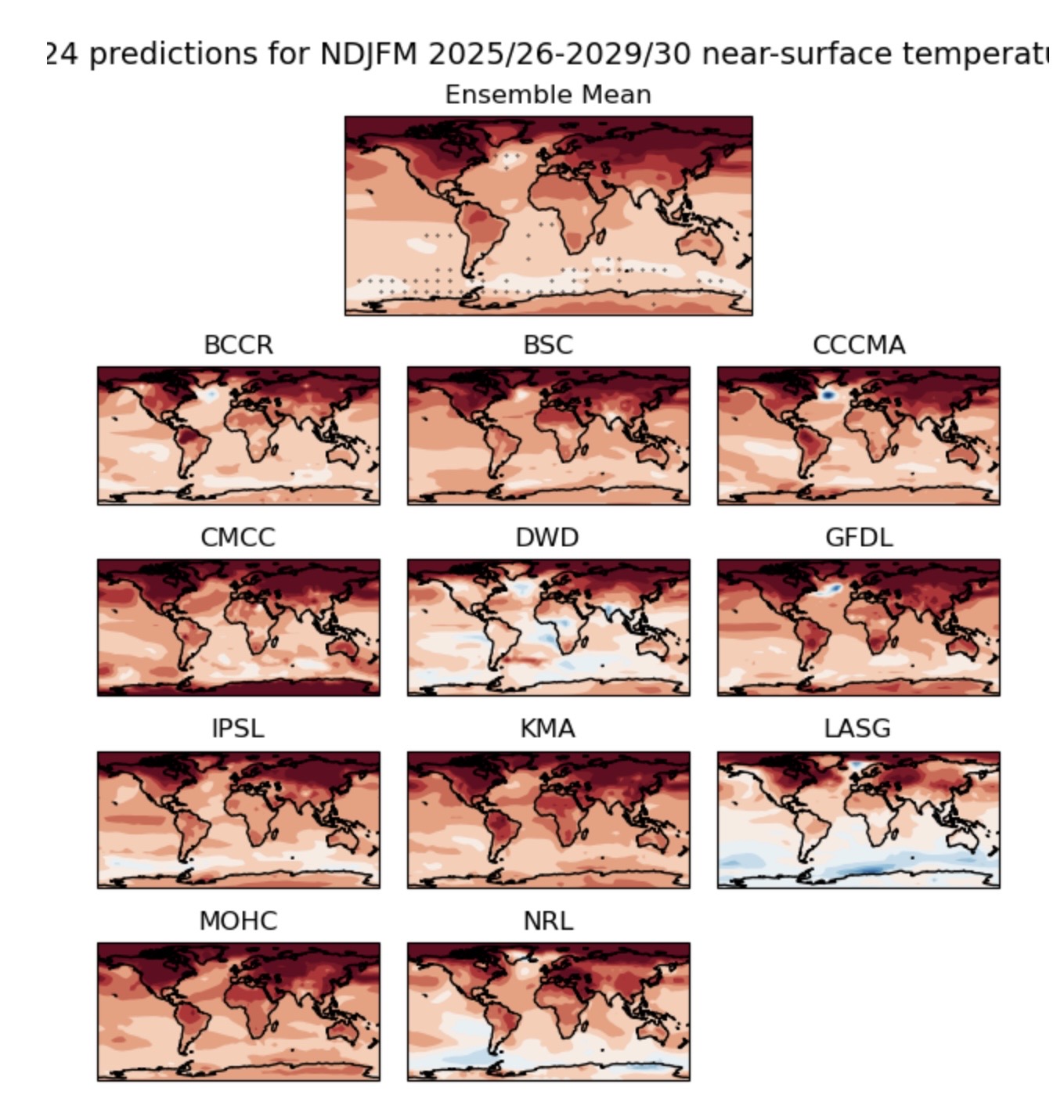
2026-2027 El Nino
40/70 Benchmark replied to Stormchaserchuck1's topic in Weather Forecasting and Discussion
Well, anything is theoretically possible when ENSO isn't overwhelming....because other factors dictate the hemispheric pattern...too early to say just yet. -
Lake Nokomis officially iced out yesterday. Just about a week ahead of the long term average. Ice-In was November 30th this year. Not bad for an urban lake. Went by Lake Minnetonka yesterday. Still quite a bit of ice still on the lake.
-
Hope so. Would be nice to have some sunny warm weekends and keep any rain for the weekdays.
-
April may end up being a month long inferno. No blocking appears to be in the cards
-
is this week one of those backdoor cold front deals? local met says 70s-80s all week, NWS says see-saw warm-cold warm-cold
-
Models were WAY too cold in the long term. What was supposed to be a cold end of the week and weekend will end up in the 60s.
-
Weekend Fri 3/27 EWR: 65 / 41 (+7) NYC: 65 / 41 (+7) Sat 3/28 EWR: 45 / 31 (-8) NYC: 44 31 (-9) Sun 3/29 EWR: 58 / 32 (-2) NYC: 54 / 34 (-3)
-

2026-2027 El Nino
bluewave replied to Stormchaserchuck1's topic in Weather Forecasting and Discussion
I think that it’s still too early to focus in on the exact magnitude of the El Niño which is beginning to emerge . We need to watch the development into June to have a better idea once we get past the spring forecast barrier. The long range climate models have more of a coast to coast ridge look going forward like we saw this March with warmth extending across the country. So this would be a departure from the cold West and Warm East configuration. This may be related to the continuous North Pacific warm pool from Japan to California not really matching any traditional PDO composite. So it’s theoretically possible that we can get a robust Coast to Coast ridge like we saw this March regardless of the exact strength of the coming El Niño. Since the record 500 mb ridge over the West this past winter really wasn’t related to the La Niña magnitude. https://hadleyserver.metoffice.gov.uk/wmolc/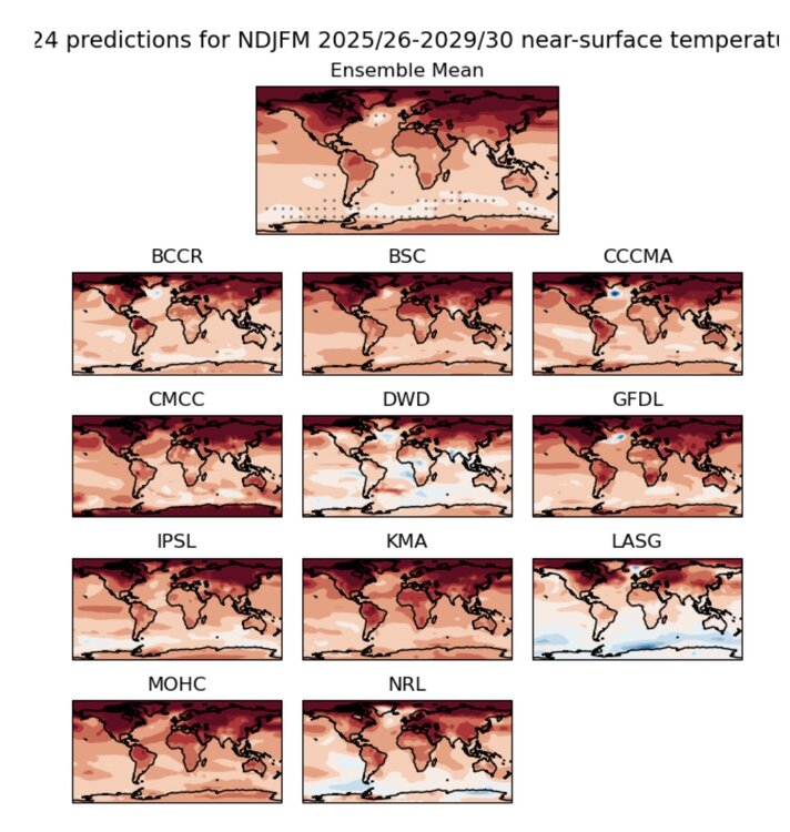
-
I look at radar and to my surprise....RAIN. But a beautiful morning down here in obx.

-

Central PA Spring 2026 Discussion/Obs Thread
Mount Joy Snowman replied to Voyager's topic in Upstate New York/Pennsylvania
Lows of 42 and 30 last night and Saturday night, respectively. Might be a good week to throw down some grass seed. - Today
-
It wasn't spring... That was winter. And the 14th/15th were not warm up here (+1.7 and -2.1), so average weekend. I loved it, skiing all day in the Catskills where it was snowing. But now that we are in spring, we will have the cold, wet weekend pattern because Little League is starting up
-
Records: Highs: EWR: 86 (1998) NYC: 82 (1998) LGA: 79 !(1998) JFK: 72 (1979) Lows: EWR: 22 (1970) NYC: 16 (1887) LGA: 23 (1970) JFK: 22 (1970) Historical: 1805: New York's City's Battery Park was strewn with 24-inch snow rollers, from a ferocious storm between the March 26th and March 28th. Snow rollers are natural snowballs that are formed when winds blow over a snow-covered surface. 1823 - A great Northeast storm with hurricane force winds raged from Pennsylvania to Maine. The storm was most severe over New Jersey with high tides, uprooted trees, and heavy snow inland. (David Ludlum) 1848: On six reported occasions, the water flow over the American Falls has been entirely blocked by ice and ceased to fall. But only once has this happened on the much larger Horseshoe Falls. 1899 - A storm which buried Ruby, CO, under 141 inches of snow came to an end. Ruby was an old abandoned mining town on the Elk Mountain Range in the Crested Butte area. (The Weather Channel) 1970: The day before, Easter was not very pleasant across northern New Jersey as up to 20 inches of snow and temperatures plunged from spring-like readings near 60° on March 26th to 2° on this date. Single digit and below zero readings occurred across parts of northern Pennsylvania. (Ref. Wilson Wx. History) 1977 - Hartford, CT, hit 87 degrees to establish a record for the month of March. (The Weather Channel) 1987 - A storm spread heavy snow across the Ohio Valley and Lower Great Lakes Region. Cleveland OH received sixteen inches of snow in 24 hours, their second highest total of record. Winds gusting to 50 mph created 8 to 12 foot waves on Lake Huron. The storm also ushered unseasonably cold air into the south central and southeastern U.S., with nearly one hundred record lows reported in three days. (The National Weather Summary) (Storm Data) 1988 - A winter-like storm developed in the Central Rockies. Snowfall totals in Utah ranged up to 15 inches at the Brian Head Ski Resort, and winds in Arizona gusted to 59 mph at Show Low. (The National Weather Summary) (Storm Data) 1989 - Thunderstorms developing along and ahead of a slow moving cold front produced large hail and damaging winds at more than fifty locations across the southeast quarter of the nation, and spawned a tornado which injured eleven persons at Northhampton NC. (The National Weather Summary) (Storm Data) 1990 - Low pressure produced heavy snow in central Maine and northern New Hampshire, with up to eight inches reported in Maine. A slow moving Pacific storm system produced 18 to 36 inches of snow in the southwestern mountains of Colorado in three days. Heavier snowfall totals included 31 inches at Wolf Creek Pass and 27 inches at the Monarch Ski Area. (The National Weather Summary) (Storm Data) 1991: Seventeen tornadoes occurred during the month in Oklahoma, setting an all time record. Oklahoma averages about four tornadoes during the month of March. (Ref. Wilson Wx. History) 1993: This apparently was not “soft” hail; good thing nobody’s head was in the way. Hail to the size of baseballs fell from Braxton to D’lo, MS. A number of mobile homes were “punctured” by the hail. (Ref. Weather Guide Calendar with Phenomenal Weather Events 2012 Accord Pub. 2011, USA) 2003: Mar. 30th: A late season snowfall left 1 to 3 inches of accumulation west of a line from Charlottesville to Baltimore City. Above 1500 feet where nearly all of the falling snow was able to accumulate, 4 to 8 inches of snow was reported, with isolated locations above 3000 feet reporting up to 12 inches. The heaviest snowfall falls in the eastern West Virginia mountains, with 16.5 inches at Davis. Blacksburg, Virginia, reported 11 inches. A foot or more fell at Boone and West Jefferson in North Carolina. (Ref. WxDoctor) 2005: In Colorado, near blizzard conditions occurred east and southeast of Denver during the overnight as winds sustained winds up to 35 mph with gusts to 50 mph produced blowing snow and dropped visibilities at times to near zero. Considerable drifting of 2 to 4 feet was also reported. Snowfall totals included: 8 inches near Castle Rock, 7 inches near Sedalia and 6 inches near Parker but Denver only reported 0.3 inches with gusty winds. Further north, the same storm system triggered numerous small thunderstorms, including a few brief tornadoes from east of Mason City, IA through Mitchell County, Iowa to near the Minnesota-Iowa state line. This area was near the center of low pressure and nearby cold/warm fronts that served as a 'triple point' to focus severe weather development. Known tornado touchdowns (local time) included: 6 miles west of Osage, IA at 2:04 pm, NW side of Stacyville, IA at 2:13 pm, and on the state line south of Adams, MN (Mower/Mitchell County) at 2:18 pm. All damage was rated F0. Wind damage also occurred in southeast Minnesota, east and northeast of Rochester, MN from wind speeds of 60-70 mph. Poseyville in extreme southwestern Indiana had a wind gust of 69 mph. (Ref. Wilson Wx. History)
-
My point and click sucks. It had today being nice. Radar says enjoy the rainy day lol
-
I’ll move to FL.
-

How best to embed pictures?
PhiEaglesfan712 replied to VBweather's topic in Forum Information & Help
What this board needs to do is remove the attachment quota (like The Weather Forums does), or at least put it high enough that we don't have to remove our old attachments on a regular basis. -
But that was a good win. I saw UConn lost the same way in 1990.
-
We’ll be watching the backdoor front especially where I am and points east this week. Hopefully a few warm days this week without that or a blasting 40-45mph Ambrose Jet. Enjoy NJ and Hudson Valley.
-
54 / 44 warmup and ridge upon us but clouds in the way of some of the hotter temps. 70s warmest spots today in/out of the clouds all week some showers too mainly wed eveing (falling from 80s to 40s in NJ), Mid 70s to 80 in the warmest Tue/Wed. Thu onshore flow chills it down to the 40s. Wamring up Fri through Easter but again clouds. Brunt of the rains around the ridge west of here. Clear out by the 6th but cool back towards normal.