All Activity
- Past hour
-
Yes, he adapted quickly. We took the drive to Shelburne Falls yesterday to pick it up and brought him along so they could make any adjustments needed. As soon as he was hooked up to it...he was going wild getting around. When we took him outside today, as soon as he saw it he almost like went right up to it and then turned himself around as if he knew what was going on. This is going to be great for him. Hopefully too this will help maybe build up some strengthen in his back legs, though not really sure that will do much at this point. We did a 3rd MRI a couple months back since he kind of regressed over the summer. It revealed the portion of his spine where the stroke occurred is slowly being replaced by fluid (which is preventing the neurons from his brain traveling to his lower extremities). So we took him off prednisone (which he had been on since the winter when we think he had a minor stroke) as it was not working as well anymore.
-
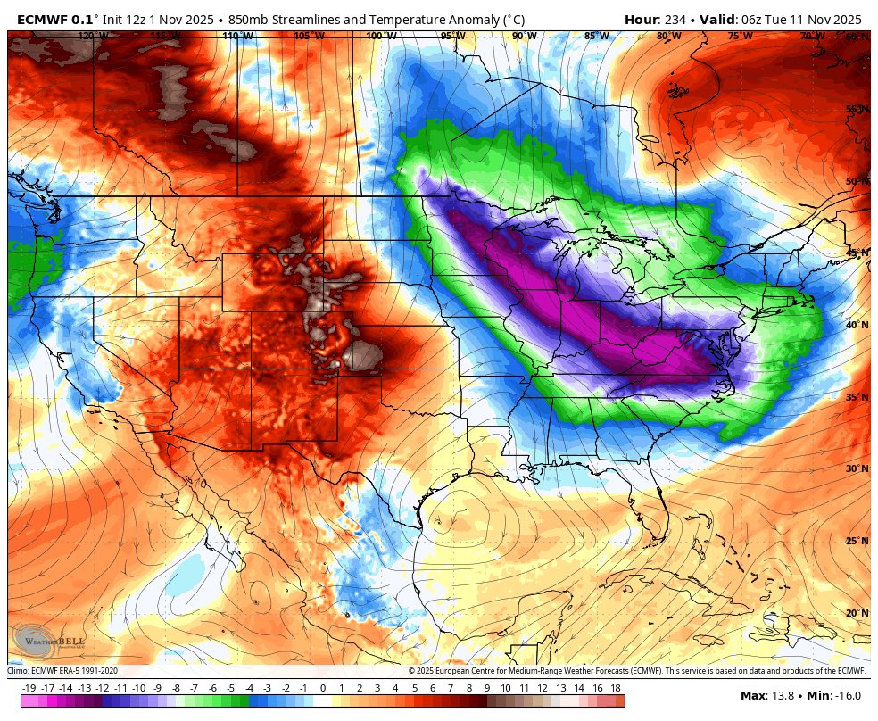
Looks like a boring zonal flow with a broad flat ridge sets up this week. Not torchy, but a bit on the mild side- 60s/40s with maybe a day or 2 around 70. Beyond that it looks changeable on the means- maybe a cool shot followed by a milder period again. Maybe trending colder mid month and beyond, but that's a couple weeks out.
-
 From Mt Holly for nearby NJ/PA ...Hunterdon County... Readington 40 MPH 0154 PM 10/31 AWOS ...Mercer County... Trenton 48 MPH 0515 PM 10/31 ASOS ...Middlesex County... Perth Amboy 46 MPH 0109 PM 10/31 WXFLOW ...Monmouth County... 1.0 NW Keansburg 47 MPH 1257 PM 10/31 HADS Sea Girt 44 MPH 1150 AM 10/31 NJWXNET SEA BRIGHT 43 MPH 1240 PM 10/31 CWOP Monmouth 43 MPH 0203 PM 10/31 WXFLOW Cream Ridge 41 MPH 0150 PM 10/31 NJWXNET Belmar Farmdale 40 MPH 0308 PM 10/31 AWOS ...Morris County... Denville 53 MPH 0303 PM 10/31 CWOP Morristown 44 MPH 0255 PM 10/31 AWOS ...Ocean County... Mantoloking 50 MPH 0316 PM 10/31 WXFLOW Harvey Cedars 48 MPH 0335 PM 10/31 NJWXNET Beach Haven 46 MPH 0111 PM 10/31 CWOP Trixies 45 MPH 1220 PM 10/31 WXFLOW Rutgers 44 MPH 0142 PM 10/31 WXFLOW Toms River 43 MPH 1122 AM 10/31 AWOS Seaside Heights 42 MPH 1223 PM 10/31 WXFLOW Seaside Heights 42 MPH 0310 PM 10/31 NJWXNET North Beach Haven 42 MPH 0515 PM 10/31 CWOP Tuckerton 41 MPH 0326 PM 10/31 WXFLOW ...Sussex County... High Point Monument 41 MPH 0305 PM 10/31 NJWXNET ...Pennsylvania... ...Berks County... LENHARTSVILLE 51 MPH 0530 PM 10/31 CWOP Reading 44 MPH 0407 PM 10/31 ASOS ...Bucks County... Doylestown 44 MPH 0132 PM 10/31 ASOS Burlington NOS 42 MPH 0330 PM 10/31 NOS-PORTS Newbold NOS 40 MPH 1212 PM 10/31 NOS-PORTS ...Chester County... WEST BRANDYWINE 47 MPH 1036 AM 10/31 CWOP White Clay Creek West Grove- 47 MPH 0140 PM 10/31 DEOS2 West Chester 41 MPH 0320 PM 10/31 AWOS ...Lehigh County... Lehigh Valley Intl Airport 43 MPH 0452 PM 10/31 ASOS ...Monroe County... Mt. Pocono 46 MPH 0459 PM 10/31 ASOS
 -
524 NOUS41 KOKX 010137 PNSOKX CTZ005>012-NJZ002-004-006-103>108-NYZ067>075-078>081-176>179- 011345- Public Information Statement National Weather Service New York NY 937 PM EDT Fri Oct 31 2025 ...HIGHEST WIND REPORTS TODAY... Location Speed Time/Date Provider ...Connecticut... ...Fairfield County... Bridgeport Airport 44 MPH 0229 PM 10/31 ASOS Danbury Airport 41 MPH 1120 AM 10/31 ASOS ...New Haven County... Lighthouse Point 45 MPH 0311 PM 10/31 WXFLOW Stony Creek 40 MPH 0330 PM 10/31 CWOP ...New Jersey... ...Bergen County... Teterboro Airport 46 MPH 0315 PM 10/31 ASOS ...Essex County... Caldwell 47 MPH 0130 PM 10/31 ASOS ...Hudson County... Bayonne 40 MPH 0122 PM 10/31 WXFLOW ...Union County... Newark Airport 53 MPH 0339 PM 10/31 ASOS Linden Airport 43 MPH 0155 PM 10/31 AWOS ...New York... ...Bronx County... Fordham 47 MPH 0355 PM 10/31 NYSM ...Kings County... Brooklyn College 48 MPH 0340 PM 10/31 NYSM South Slope 47 MPH 0347 PM 10/31 CWOP ...Nassau County... Bayville 52 MPH 0356 PM 10/31 WXFLOW Wantagh 47 MPH 0355 PM 10/31 NYSM 1 ESE Long Beach 42 MPH 1030 AM 10/31 AWS Massapequa 41 MPH 0334 PM 10/31 CWOP 0.8 NW Uniondale 40 MPH 0230 PM 10/31 MESOWEST ...New York (Manhattan) County... Midtown Manhattan 40 MPH 0200 PM 10/31 NYSM ...Orange County... Montgomery Airport 46 MPH 0246 PM 10/31 AWOS Warwick 42 MPH 0405 PM 10/31 NYSM Stewart Airport 40 MPH 0345 PM 10/31 AWOS ...Queens County... NYC/JFK Airport 49 MPH 0315 PM 10/31 ASOS NYC/La Guardia 47 MPH 0331 PM 10/31 ASOS Kew Garden Hills 47 MPH 0340 PM 10/31 NYSM Breezy Point 41 MPH 0352 PM 10/31 WXFLOW ...Richmond County... 2 SE Elizabeth 49 MPH 0330 PM 10/31 NDBC College of Staten Island 46 MPH 0140 PM 10/31 NYSM ...Rockland County... Suffern 42 MPH 0320 PM 10/31 NYSM ...Suffolk County... Montauk 58 MPH 0823 PM 10/31 ASOS Stony Brook 57 MPH 0248 PM 10/31 CWOP Great Gull Island 53 MPH 0353 PM 10/31 WXFLOW Fair Harbor 51 MPH 0239 PM 10/31 CWOP Eatons Neck 50 MPH 0233 PM 10/31 WXFLOW Westhampton Airport 48 MPH 0332 PM 10/31 ASOS Fishers Island Airport 46 MPH 1238 PM 10/31 WXFLOW Islip Airport 46 MPH 0248 PM 10/31 ASOS Orient 46 MPH 0405 PM 10/31 CWOP Farmingdale Airport 45 MPH 0227 PM 10/31 ASOS Fire Island CG 45 MPH 0335 PM 10/31 WXFLOW Southold 45 MPH 0345 PM 10/31 CWOP East Moriches CG 44 MPH 1105 AM 10/31 WXFLOW Shirley Airport 44 MPH 0318 PM 10/31 ASOS West Gilgo Beach 43 MPH 0410 PM 10/31 CWOP Baiting Hollow 43 MPH 0410 PM 10/31 CWOP Brookhaven 41 MPH 0245 PM 10/31 CWOP Blue Point 40 MPH 0300 PM 10/31 WXFLOW ...Westchester County... Tappan Zee Light 14 40 MPH 0234 PM 10/31 WXFLOW White Plains Airport 40 MPH 0302 PM 10/31 ASOS ...Maritime Stations... ...Connecticut... Stongington Outer Breakwater 50 MPH 1207 PM 10/31 WXFLOW 1 ESE Norwalk 44 MPH 0237 PM 10/31 WXFLOW ...New Jersey... Jersey City 55 MPH 0218 PM 10/31 CWOP ...New York... Robbins Reef, NJ 52 MPH 0330 PM 10/31 NOS-PORTS Shinnecock 50 MPH 1120 AM 10/31 WXFLOW 26 SSE Robert Moses State Pa 49 MPH 0220 PM 10/31 NDBC Kings Point 46 MPH 0400 PM 10/31 NOS-NWLON 15 S Atlantic Beach 45 MPH 0230 PM 10/31 NDBC Point O Woods YC 45 MPH 0347 PM 10/31 WXFLOW Northport 43 MPH 0215 PM 10/31 DAVIS Larchmont Harbor 43 MPH 0357 PM 10/31 WXFLOW Fire Island CG 42 MPH 0336 PM 10/31 WXFLOW &&
-
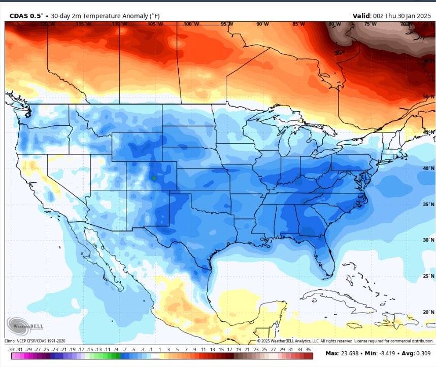
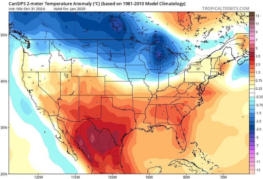
A little lesson from last year especially with the CANSIPS. The first picture was the modeled temperatures for last January. The second picture is the actual temps we had in January. The third picture is the modeled temps for January 2026. Now this can go either way but I don't put much stock in these long range predictions anymore. Sent from my SM-G998U using Tapatalk

-
Dogs adapt, looks good Paulie.
-
While I understand that we do not want to have the perfect pattern in November, I'm glad that we do not appear to be staring down the barrel of a wall-to-wall Pacific Puke™ fest. If I recall correctly, @Rainshadow had posted some stats in the past about the implications of mild to torch Novembers vs. average to below average November temperatures. Equally encouraging is to see the CFS and CANSIPS trying for at least climo temps for winter.
-

Spooky Season (October Disco Thread)
DavisStraight replied to Prismshine Productions's topic in New England
I forgot about hophorbeam, not a lot of it where I lived, would have loved to have a couple cords back in 2015 - Today
-

Spooky Season (October Disco Thread)
Damage In Tolland replied to Prismshine Productions's topic in New England
Cocked? -
Peppers in full grow and new blooms on Nov 1. I planted them first weekend of Mayorch . https://imgur.com/a/BuLsAUA
-
Ravens and Eagles trade https://www.profootballrumors.com/2025/11/eagles-trade-for-ravens-cb-jaire-alexander#ref=home
-

November 2025 general discussions and probable topic derailings ...
weathafella replied to Typhoon Tip's topic in New England
Everyone is say how warm it is but it feels close to normal for today’s high of 56. Currently 49. -
First cold airmass arrives near November 10th and the 11 th. Could be a rather intense cold frontal passage. Warmth prior to this, with next Saturday having the potential to hit 66 to 67 degrees. This Wednesday highs near 63 to 65.

-

November 2025 general discussions and probable topic derailings ...
mreaves replied to Typhoon Tip's topic in New England
It is insane to go there on a weekend. I’m not sure what I was thinking. I guessed the elevation based on a lack of snow anywhere here 1500’ and up. -
November 2025 general discussions and probable topic derailings ...
weathafella replied to Typhoon Tip's topic in New England
My landscaping guys unexpectedly came and blew everything clean. Will probably need another round before the final fall cleaning. Then the gutters after everything is up. -

12th Annual Mid-Atlantic Snowfall Contest
RickinBaltimore replied to RodneyS's topic in Mid Atlantic
BWI: 5.3" DCA: 3.9" IAD: 4.4" RIC: 2.8" Tiebreaker: SBY: 1.4" -

November 2025 general discussions and probable topic derailings ...
Torch Tiger replied to Typhoon Tip's topic in New England
Borrow Ginxs phone for that pic? sheeeesh -
The first hour was picking up all the limbs and sticks that blew down last night . Then blow. Then tractor for stragglers .
-

November 2025 general discussions and probable topic derailings ...
SJonesWX replied to Typhoon Tip's topic in New England
It’s November 1st you clown. You are a braver man than me. thankfully I had plans all day today so tomorrow will be leaf disaster/pick up day -
 Yesterday's winds took a lot of the leaves down. Probably 50% down ( And yes, the lawn looks nice and green here too )
 -

Central PA Fall Discussions and Obs
canderson replied to ChescoWx's topic in Upstate New York/Pennsylvania
A gorgeous evening - Sunday looks equally spectacular. -

Major Hurricane Melissa - 892mb - 185mph Jamaica landfall
Normandy Ho replied to GaWx's topic in Tropical Headquarters
On top of two other cat fives. Just a stupid season . From the images I’ve seen this is some of the worst wind damage I’ve ever witnessed. Turning the west end of Jamaica brown from space is wild -

November 2025 general discussions and probable topic derailings ...
CoastalWx replied to Typhoon Tip's topic in New England
lots of leaves here still but a lot came down last night. Lawn looks great for Mowvember. -
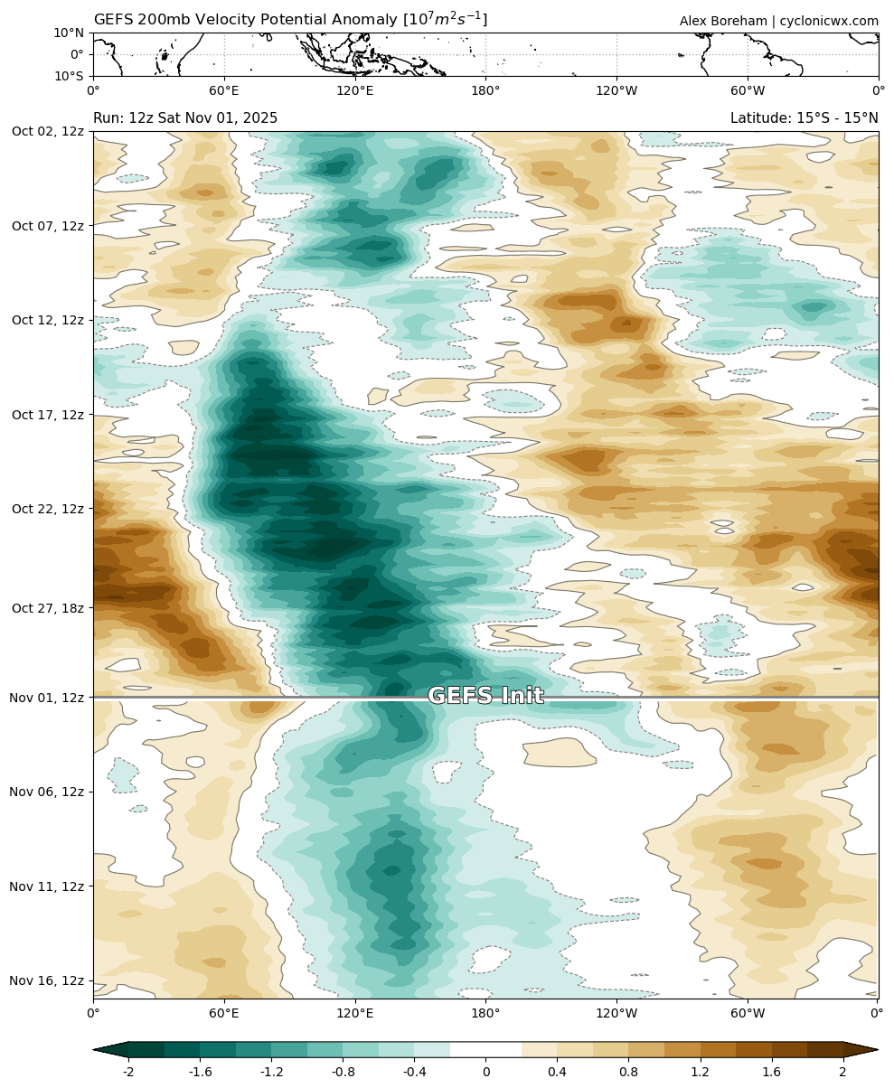
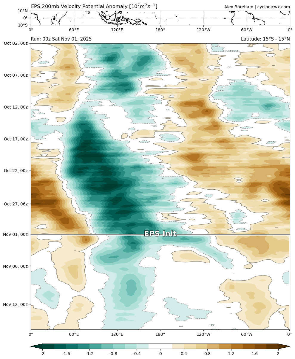
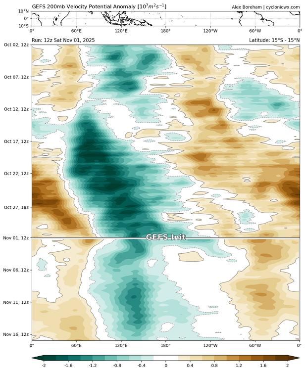
Curious to see how the mjo behaves this week. Eps dampens the wave as it has been throughout. Gefs is more amped. But, both of those things are known biases of each respectively as far as I know (lol). In real time thus far the Gefs has been verifying better (stronger). That doesn't necessarily mean that will continue though. Nobody knows for certain, we watch. Looking forward to the CPC update on Monday. For now here's Gefs and eps forecasts followed by the current map. There does appear to be kelvin wave like feature visible too on these charts, slicing through the overall mjo signal at faster speed. Those have been a catalyst in propagating this event thus far according to other CPC updates. How well are they modeled?

-
They go quickly in deez hills. The winds the last 5 or so days certainly helped