All Activity
- Past hour
-
The other positive even if it trends north we don't have to worry about temps probably
-
.thumb.png.3d2e093654824a1058d3954bf0e1e25a.png)
-

January 2026 Medium/Long Range Discussion
NorthArlington101 replied to snowfan's topic in Mid Atlantic
Zoomed version -

January 2026 Short/Medium Range Thread
Holston_River_Rambler replied to John1122's topic in Tennessee Valley
We need a mountain wave event with the ice too, that'll help. -
Yeah hopefully the euro improves and we have just the gfs in its usual suppression lala land
-
14.6" on the season just over the river in Somerset. 5" OTG this morning, with 5.7" in total over the past 2 days. I'll be working on compiling NJ snow totals for these two separate events that we'll post here: http://climate.rutgers.edu/stateclim/?section=menu&target=wint2526snowtotals Since the 1/18 event started before most morning ob times in 1/18, it will take some effort to split out the 1/17 and 1/18 snowfalls.
-
Surprised to see that. I would have thought it would be suppressed.
-
Ukie 2 feet +
-
Ukie...thunder ice anyone...valley is sitting right at 33
-
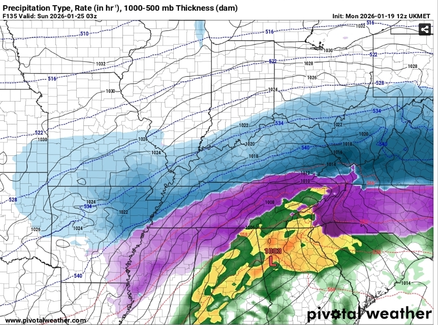
The 12z UKMET absolutely buries most of the forum.
-
Nice to see CMC come aboard. There's more support than just the AI models. And these things usually trend north unless there's a massive -NAO type block
-
GEFS has a huge signal for Bob Chill, technically a shift south but our snow mean improves a lot as well!
-

Southern MD / Lower Eastern Shore weather discussion
csnavywx replied to PrinceFrederickWx's topic in Mid Atlantic
Normally we lose out in these CAD-type storms. This one looking different. Northern stream looks strong and suppressive and the subtropical jet is finally coming back from the dead. -
Im sure you'll find a way to manage with only 2 feet of snow.
-

January 2026 regional war/obs/disco thread
40/70 Benchmark replied to Baroclinic Zone's topic in New England
Yea, not that into next weekend. -
12z UKMET much further south than 0z, still tries to run low into heart of the CAD, regardless of trying to do that, it's an absolute mess of a storm across much of NC and would be bad in many ways!
.gif.f14e14f11bea0235d61e4eccef9e7fe7.gif)
-
UKMET is FOLKS
-

E PA/NJ/DE Winter 2025-26 Obs/Discussion
LVblizzard replied to LVblizzard's topic in Philadelphia Region
Someone posted the Kuchera map in the Mid-Atlantic subforum. 16-28” for all of us. Would be up there with the all time greats. -

January 2026 Short/Medium Range Thread
fountainguy97 replied to John1122's topic in Tennessee Valley
It did. Good tick south -
Totally makes sense. When we hit, we can hit big, but we also fail big and often. I find it interesting and awesome that the three hits on this run are an overrunning/SWFE event, what kind of looks to be a Miller B, and a storm riding up the coast. Three ways to win, three ways to fail.
-
see at least for Feb 20 2025 the GFS wasn't on an island, it had the euro ai. now the gfs is on a fucking other universe where different laws of physics occur
-

Storm potential January 17th-18th
495weatherguy replied to WeatherGeek2025's topic in New York City Metro
I believe I received closer to 4 inches in Melville, but I didn’t measure. Going by eyeball, I think your measurement is close to what I received from the entire event -

January 2026 regional war/obs/disco thread
dryslot replied to Baroclinic Zone's topic in New England
Good luck getting a storm into New England with this cold west to east flow
-
Probably one of the times where it might prove more useful
-

Pittsburgh/Western PA WINTER ‘25/‘26
RitualOfTheTrout replied to Burghblizz's topic in Upstate New York/Pennsylvania
Snow Squall warnings all over. Ive been stuck in-between two with the sun peaking out, hope the pivot or fill in.


.png.7da2f9fc550a1247d7f0c2c1f92b1e93.png)


