All Activity
- Past hour
-
It looks like models have generally below normal temps in the east for the remainder of the month.
-
(002).thumb.png.6e3d9d46bca5fe41aab7a74871dd8af8.png)
Central PA Fall Discussions and Obs
ChescoWx replied to ChescoWx's topic in Upstate New York/Pennsylvania
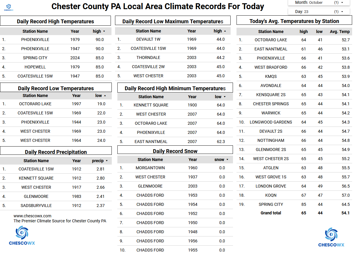
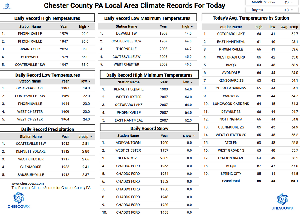
The NWS has issued a Frost Advisory for tonight for the entire area. However, many spots below 500 ft ASL in Chester County have already seen multiple freezing mornings. Those valley spots may again see freezing temperatures while some higher spots could see some frost but likely staying above freezing. For the rest of October, we should see below normal temperatures with daytime highs falling from the upper 50's today to the low 50's for highs by the start of the new work week. Lows should be frosty most mornings with a widespread freeze possible by next Monday and Tuesday mornings. We stay dry until our next chance of showers on Tuesday night.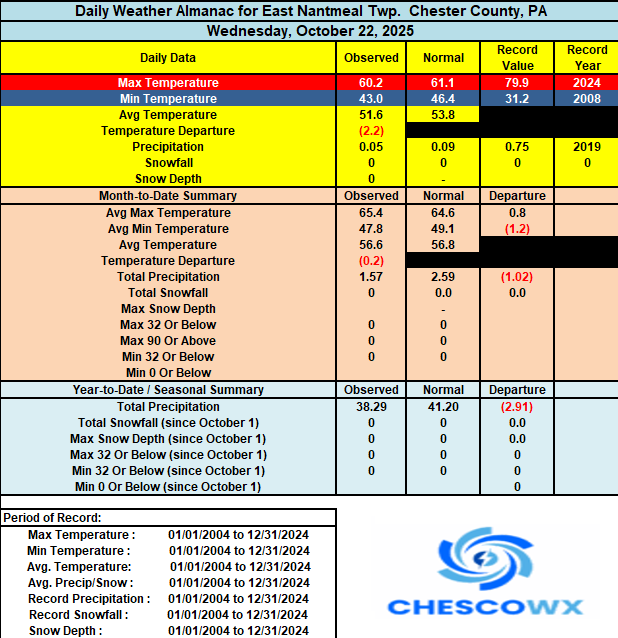
-
E PA/NJ/DE Autumn 2025 Obs/Discussion
ChescoWx replied to PhiEaglesfan712's topic in Philadelphia Region
The NWS has issued a Frost Advisory for tonight for the entire area. However, many spots below 500 ft ASL in Chester County have already seen multiple freezing mornings. Those valley spots may again see freezing temperatures while some higher spots could see some frost but likely staying above freezing. For the rest of October, we should see below normal temperatures with daytime highs falling from the upper 50's today to the low 50's for highs by the start of the new work week. Lows should be frosty most mornings with a widespread freeze possible by next Monday and Tuesday mornings. We stay dry until our next chance of showers on Tuesday night.
-

Spooky Season (October Disco Thread)
ineedsnow replied to Prismshine Productions's topic in New England
Almost every eps member at 6z is west of the op for melissa.. coastal looks to be a given -
Lately if we score in a Nina it's in December.
-
Light frost and 34.5
-

Spooky Season (October Disco Thread)
CoastalWx replied to Prismshine Productions's topic in New England
Euro was a pretty nasty coastal. -
2013 was the 2nd best storm In my lifetime in CT. Received 22 inches in Norwalk CT. The blizzard of 1996 was the only storm that i lived through with more snowfall (27 inches Norwalk CT).
-
Interesting temperature gradient

-
Spooky Season (October Disco Thread)
CoastalWx replied to Prismshine Productions's topic in New England
Disappointment in Tolland -

Central PA Fall Discussions and Obs
pawatch replied to ChescoWx's topic in Upstate New York/Pennsylvania
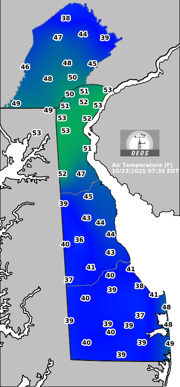
Lake is still pretty warm, I think 62 degrees . 49 degrees for the low this morning. -
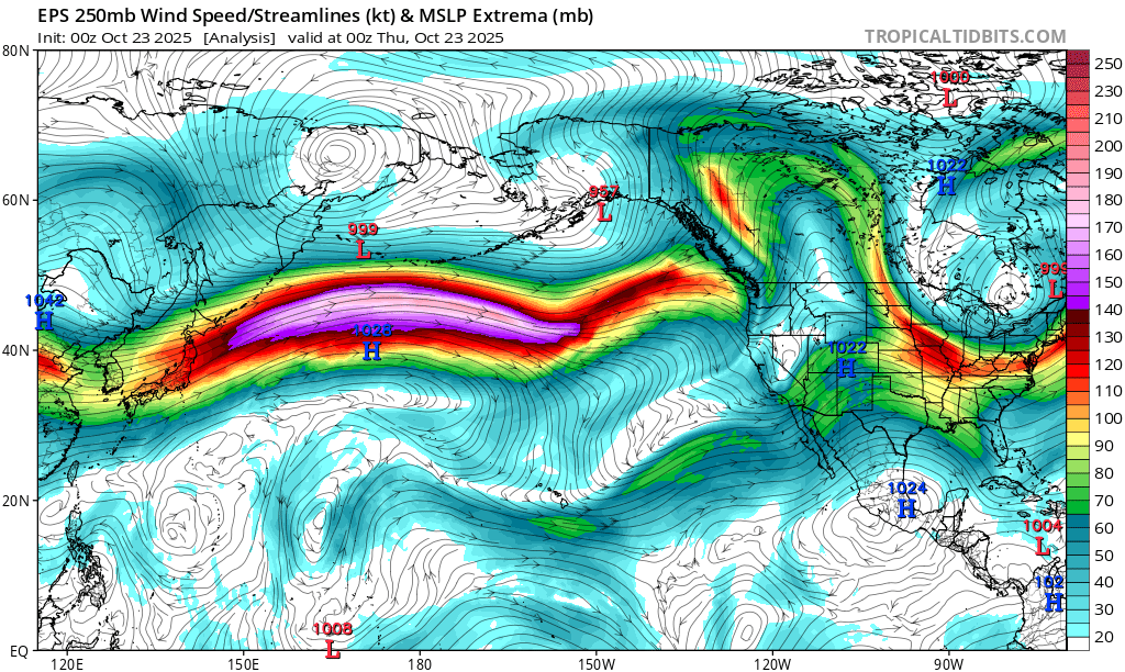
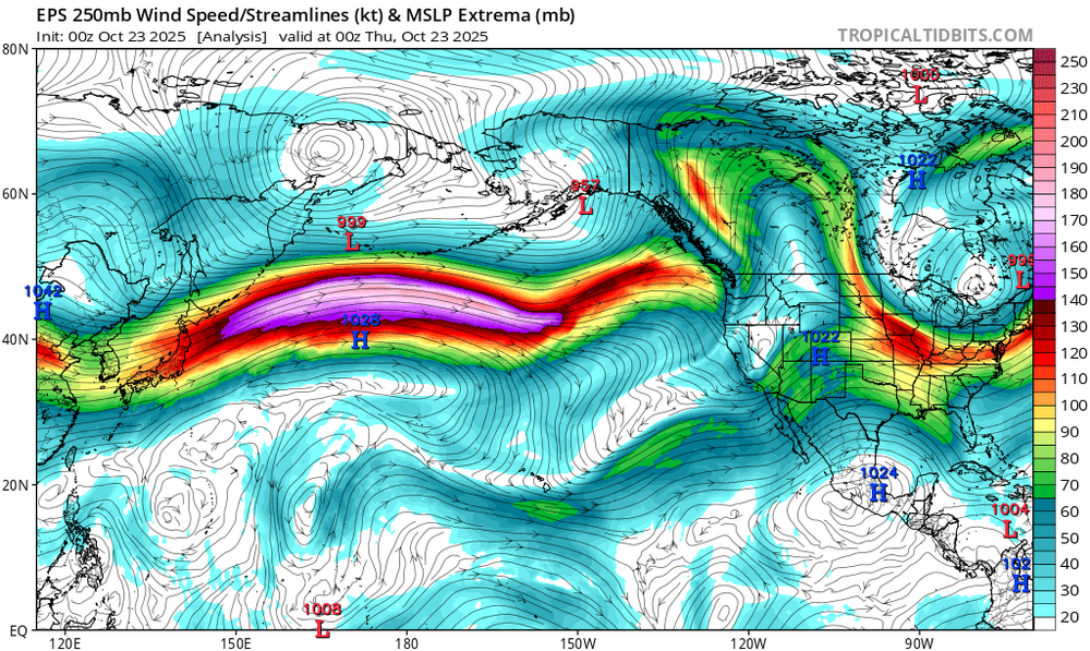
This gradient between the record SST warmth east of Japan and the Arctic cold over NE Asia is driving this very fast North Pacific Jet. So it has been very challenging to sustain the -EPO and -WPO intervals for long. Prior to 2019, we would get extended -EPO and -WPO intervals instead of these rapid shifts between positive and negative states. https://downloads.psl.noaa.gov/Public/map/teleconnections/epo.reanalysis.t10trunc.1948-present.txt
-
Waves.
-
I may have to start posting BAM winter outlooks soon.
-

Central PA Fall Discussions and Obs
mahantango#1 replied to ChescoWx's topic in Upstate New York/Pennsylvania
Hazardous Weather Outlook National Weather Service State College PA 336 AM EDT Thu Oct 23 2025 PAZ036-057-059-063>066-240745- Franklin-Dauphin-Lebanon-Cumberland-Adams-York-Lancaster- 336 AM EDT Thu Oct 23 2025 This Hazardous Weather Outlook is for central Pennsylvania. .DAY ONE...Today and tonight. The first widespread frost of the season may occur on Thursday night. .DAYS TWO THROUGH SEVEN...Friday through Wednesday. Widespread frost is more likely on Friday night. Otherwise, the probability for widespread hazardous weather is low. .SPOTTER INFORMATION STATEMENT... Spotter activation is not expected at this time. -
Lake effect rain doesn't have a ratio of a billion to 1 to fluff it up. Plus it's still kind of fake because you drive for 5 minuites and there's no rain and sunny skies.
-

Spooky Season (October Disco Thread)
dendrite replied to Prismshine Productions's topic in New England
Hopefully that gut feeling someone had last night wasn’t baked bean related. -

E PA/NJ/DE Autumn 2025 Obs/Discussion
Mikeymac5306 replied to PhiEaglesfan712's topic in Philadelphia Region
Wouldn't sweat anything just yet. Long way to go with it. This mornings 6Z GFS has it hitting us. Euro takes it just off the coast with a glancing blow S and E CMC backs the storm up about two days. Lots of work to do with this one. -
When cold air aloft is moving in from the west to north. At other times, 3-5 degrees per 1000 ft.. Observations based on frequent visitation to a location 20 miles northwest at 4400 ft. which is about 3000 ft. higher than my 1400 ft. elevation at home. When a warm front is knocking from the southwest it can be warmer at 4400 ft..
-

Spooky Season (October Disco Thread)
SouthCoastMA replied to Prismshine Productions's topic in New England
always a long shot to pull in Melissa..maybe still a coastal - Today
-

E PA/NJ/DE Autumn 2025 Obs/Discussion
pl0k00n111 replied to PhiEaglesfan712's topic in Philadelphia Region
Hopefully halloween will be spared, I put on a nice halloween in our yard. Would hate that! -
@Gawx Sunspot average for October is 125. While an obvious downtrend from last year’s solar max, solar and geomag activity remain high
-
Peekskill
-

Spooky Season (October Disco Thread)
Chrisrotary12 replied to Prismshine Productions's topic in New England
We’d be better off if Melissa didn’t exist and let the trough work on its own. -

Spooky Season (October Disco Thread)
CT Rain replied to Prismshine Productions's topic in New England
She's gone.