All Activity
- Past hour
-
Super sharp west-to-east cutoff on last night's rain. I was right on the edge and got 0.5 with 1-2 inch amounts just north, while places close to my south got nothing. Another chance today with this juicy bit from LWX: For now, holding off on a Flood Watch given the coverage of storms today. Still may need one in upcoming shifts especially in and around the Washington DC metro north along I-270 and back across the eastern WV Panhandle where max/mean values from the CAMS paint a solid 1-3 inches of rain with localized bullseye up to 5"
-
You’re right..we just need another +10 degrees in both metrics and we’re truly in business!
-
From this mornings HWO from LWX about the upcoming heat An extended period of excessively hot and humid conditions is expected Sunday through at least the middle of next week. Daily heat indices in the afternoon and evening of 100 to 110 are expected, and up to 115 degrees is possible.
-
Low of 68 overnight with 0.13" of additional rainfall.
-
humidity looks p locked in for a while so hopefully we've shaken off the doldrums again
-
Yup. Still socked in clouds and fog. Miserable.
-
Woke up to 70 degree and humid. Summer has arrived.
-
1.03” here since Monday evening, 2.84” for the month.
-
Thanks - got a little work from home, some potential storms, PCA tonight, camping tomorrow. Weather and life is good boys
-
Long lasting epic Heat wave failing? Maybe , Will be interesting to see if that backdoor moves up in time.. I think Sunday through Tuesday are guaranteed to be hot .. after that we will see.. Saturday should be a top 5 summer day.. just no oppressive..
-
Only about 2” behind you for June. Catching up!
-
selling severe prospects this far north, clinging to some coma head rain hopes your prospects obv better
-
Picked up .3” from a passing storm around 11pm, another .2” from a storm at 5am
-
-
Tue still looks hot, but Mon and Wed have come down a little up here…even Tue a little. Looks like we lost a couple C on the 850s. Euro backdoors Wed night.
-
You guys get all the rain
-
It really has been feeling like Groundhog Day. Everyday is the same gloomy morning. This morning though it feels like soup outside.
-
Day #5 with rain.
-
But it’s done this multiple times since its upgrade and never has come close to verifying
-
Another waste of a day today
-

Central PA Summer 2025
Mount Joy Snowman replied to Voyager's topic in Upstate New York/Pennsylvania
Low of 68 and .18” of precip. Summer has arrived. -
What we thinking
- Today
-
Two rounds of rain/storms in hunt valley overnight - will be curious what fell at the girlfriend’s farm in fallston in last 24 hours - we set up a rain gauge there a few weeks ago so will get that info from her in a bit.
-
Woke up to the muggies, but still raining. 0.79” in the stratus and more coming. 64.9° -RA
-
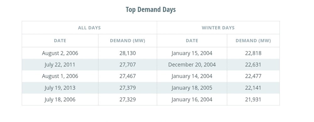
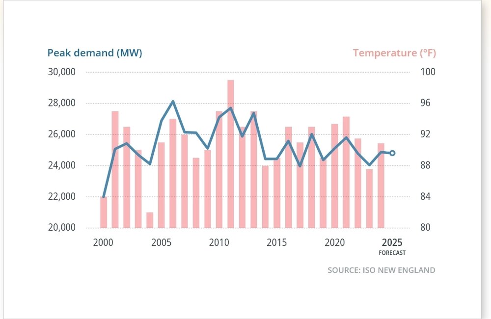
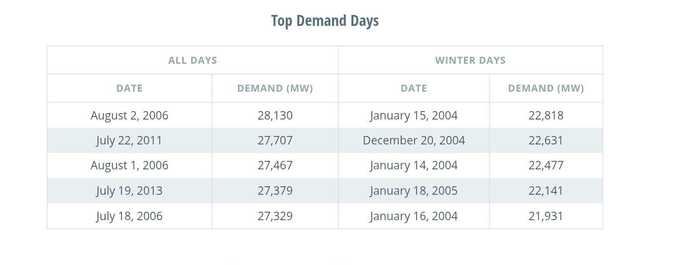
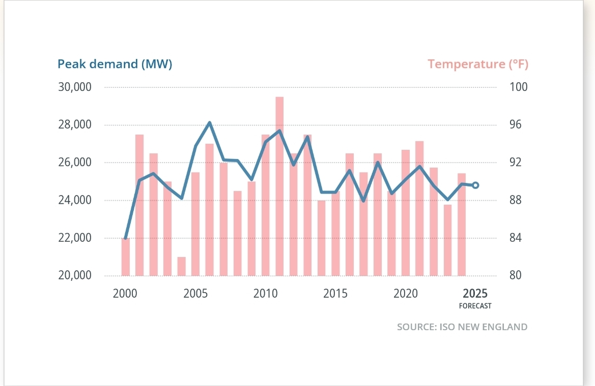
Will probably be some top demand day records next week for ISO New England, especially since the bulk of the heat is midweek. Anyone know how any of these top demand days compare to next week? The large drop in peak demand from 2013 on has been mainly due to residential solar deployment and energy efficiency gains.