All Activity
- Past hour
-

December 2025 regional war/obs/disco thread
Damage In Tolland replied to Torch Tiger's topic in New England
There’s a few shots Wed— next weekend. Might only be one .. or possibly two different light events . Fast flow -
I received 2.5" (maybe 2.8" figuring in compression), so I would naturally assume Central Park was not going to excced central Union County NJ (about 10 miles south/southwest of Newark Airport). But the storm was farther north and east, so the CPK measurement is not suspect, in my opinion...
-
Gfs has the NYD clipper - we are in business.
-

December 2025 regional war/obs/disco thread
Ginx snewx replied to Torch Tiger's topic in New England
2nd -
I still contend that the lack of snow in areas such as Union county NJ was that the center for the storm was too far north. Areas north and east of NYC got the jackpot. Without enough lift in my area, the storm dynamics fizzled. Had the storm been more intense, it would have easily overcome the "warm nose" and "dry slot". To reiterate an earlier post, we are mainly disagreeing over semantics.
-
December 2025 regional war/obs/disco thread
Damage In Tolland replied to Torch Tiger's topic in New England
NYD can be a 1-3” type deal -
Does not happen often. 93/94 obviously 2/8 and 2/11 is the most memorable case. 95-96 I do not recall any really, seemed like the close together events were small and melted and the big ones had separation and we had a massive thaw too. 09-10 I think had a couple of instances.
-
Wounded Duck Strikes Back: Dec 26 & 27th Winter Storm Obs
Ginx snewx replied to WxWatcher007's topic in New England
Toss that 8 in Jewett city I was there maybe 6 -
We have had longer lasting December snowpack in the past with other 10”+ snowfall Decembers on Long Island without a big warm up and rain following the heavier snows. But these warm ups and rain following the heavier snows have become more common in December and the other winter months that we have had heavier snows. Unfortunately, Long Island weather records don’t go back as far as other spots across the region. But the snowfall this December isn’t that far from what used to be normal a spots with longer periods of record in the past colder climate era. Those colder era Decembers didn’t have the magnitudes of the warm ups with rain. So they had better snowfall retention foe what fell relative to today.
-

December 2025 regional war/obs/disco thread
HoarfrostHubb replied to Torch Tiger's topic in New England
Not much there. -
To answer your question............... NO................ Snow results from precipitation when the 5000 ft. temperature is below 32 F.
-
What are the years of January MECS/HCES that were forecast 5+ days, compared to those that came together T-Minus 72 hours. Starting timeframe is 1978. What were the biggest surprises during that time?
-
I expect January to be colder than normal and at times slightly milder than normal and February to be overall colder than normal and March to be slightly colder than normal.
-
Can’t have everybody on the board biased for snow!
-

December 2025 OBS and Discussion
coastalplainsnowman replied to wdrag's topic in New York City Metro
Granted I'm on Long Island, but I can probably count on one hand the number of years in the last 45 that we had significant snowcover last until the next big storm. New snow on top of old snow has always been quite rare. 93/94 of course is one such year, but even 95/96 notably was not. In the 80s we had a few years where the snow from a moderate clipper lasted a few weeks in a very cold month, but again the Blizzard of '83 year was practically snowless right up to that storm, and was mild almost immediately after it. Not saying the trend hasn't been toward more frequent mild spells, but it was almost never anything close to wall-to-wall winter around here. -
I wish 1996 was not Nina lol
-
Zzzzzzz
-
But Chuck is going to find some anomalous dm somewhere
-
He's busted with everything hes said for about 90 days now. Its been rough for him
-
I think we’ll see that trough drop further west and south over time. You can see the run to run changes on the models, adjusting to our -NAO.
-
JI - I have respect for your opinion........... I will do an in depth comparison of these variations and let you know.
-
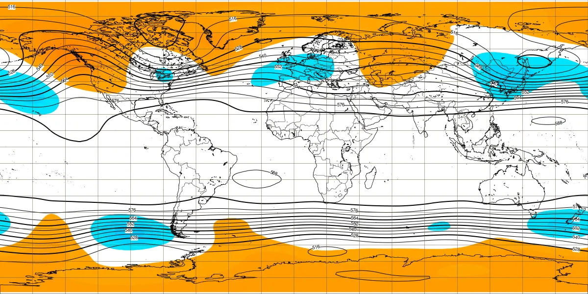
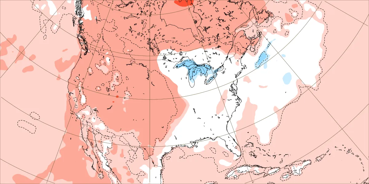
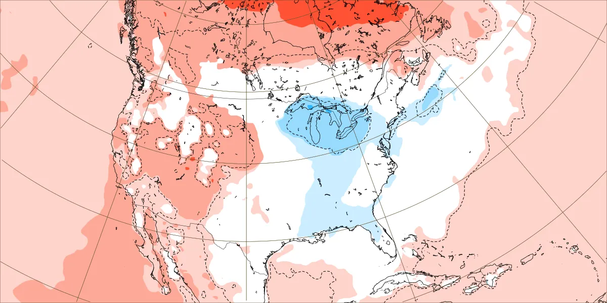
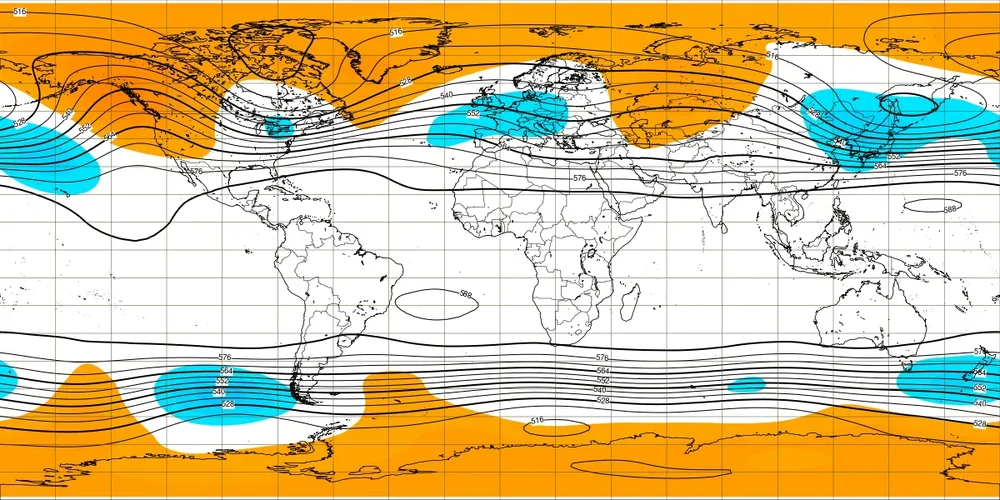
Today’s Euro Weeklies were better overall for E US, incl 1/12-18 Today H5: Yesterday 2m: Today 2m:


-
Looks like they captured it to me.
-
December 2025 regional war/obs/disco thread
Ginx snewx replied to Torch Tiger's topic in New England
More and more mesos printing out over 1 inch of qpf in sub freezing temps in your area. -
Things are lining up folks. There's a clear trend in our favor: