All Activity
- Past hour
-

January 24-26: Miracle or Mirage JV/Banter Thread!
aldie 22 replied to SnowenOutThere's topic in Mid Atlantic
I'm waiting for the first "That's a big ass dry slot" comment -

January 24-26: Miracle or Mirage JV/Banter Thread!
stormtracker replied to SnowenOutThere's topic in Mid Atlantic
Dogfish 90 minute IPA -

January 2026 regional war/obs/disco thread
Damage In Tolland replied to Baroclinic Zone's topic in New England
Some show a 2nd blizzard next weekend. As do some ensembles -
True, but I wonder if having the SW come east quicker just raises the ability for it to phase while if it stays west long enough the NS will interfere destructively. Honestly I have no idea anymore.
-
39 now
-

January 2026 regional war/obs/disco thread
40/70 Benchmark replied to Baroclinic Zone's topic in New England
Just stating what the models show attm. -
That heavy band heading northeast looks good
-

January 24-26: Miracle or Mirage JV/Banter Thread!
Kay replied to SnowenOutThere's topic in Mid Atlantic
Oh no. Hope you feel better soon. -
Thanks! .
-
I was just contemplating the same and yes, farther east. May make for a shorter duration system but will limit the heights rising and mix threat
-

January 25/26 Jimbo Back Surgery Storm
Brick Tamland replied to Jimbo!'s topic in Southeastern States
And today's runs are still not as extreme of a difference as the Euro went from yesterday morning to this morning. -
Yeh and I’d still be fine with that. .
-

Possible Record Breaking Cold + Snow Sunday 1/25 - Tuesday 1/27
qg_omega replied to TriPol's topic in New York City Metro
We had a few high ratio clippers in the old days -
Another bust on guidance here, been snowing decently for 3 hours.. almost an inch.. nothing really had measurable here
-
The northern stream feature on that Euro run was likely much different from what most guidance is showing now. It has really trended west in the last 2 days.
-
Wonder if we actually want the phase further west or further east. I think further east is better as it gives it less time to pump the ridge in front? Conversely, a further west phase may leave more energy behind so who knows.
-
Yes and pivotal to my knowledge
-

January 25/26 Jimbo Back Surgery Storm
Silver Meteor replied to Jimbo!'s topic in Southeastern States
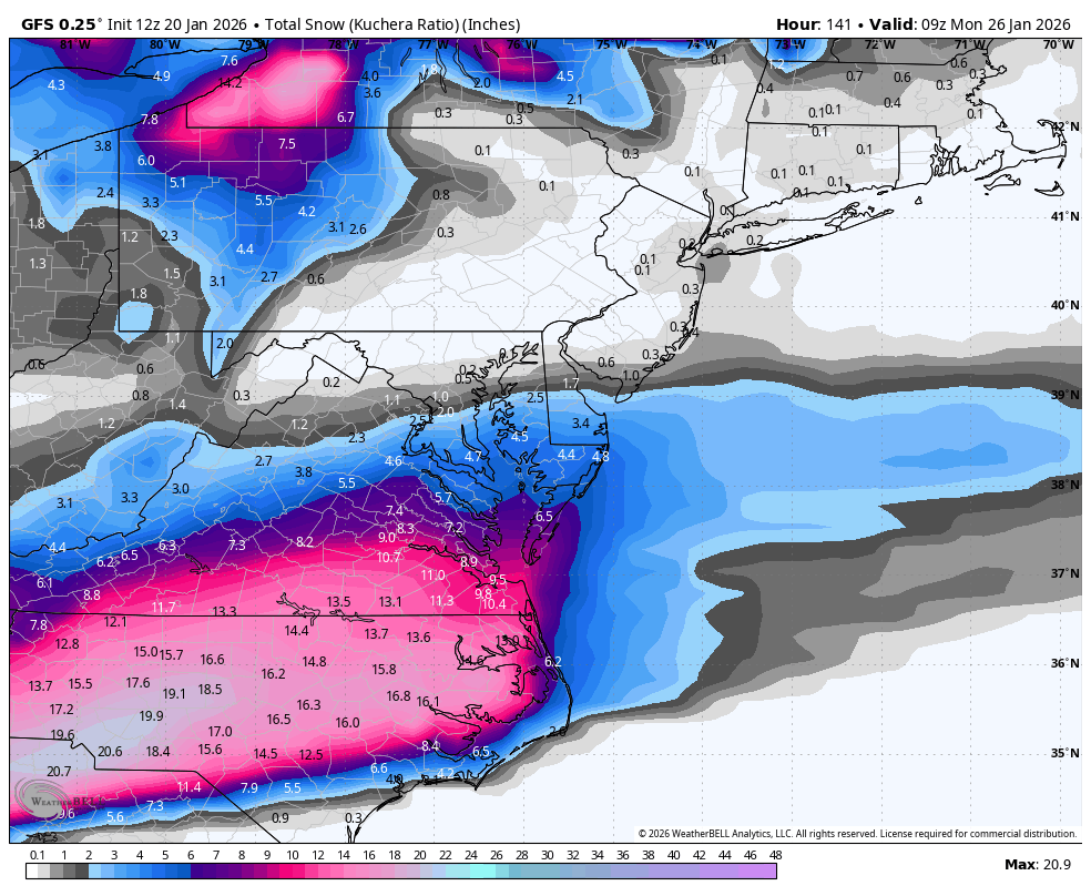
Right, right ... the GFS has done such a great job. Let me remind you of yesterday's 12Z run:
-

January 24-26: Miracle or Mirage JV/Banter Thread!
wxdude64 replied to SnowenOutThere's topic in Mid Atlantic
Diet dew and Mucinex cold and Flu? lol -

January 24-26: Miracle or Mirage JV/Banter Thread!
mattie g replied to SnowenOutThere's topic in Mid Atlantic
Mentally preparing for H5 maps that look good for us but end up flipping us to sleet on Sunday morning, followed by day-long snizzle. -

January 25/26 Jimbo Back Surgery Storm
Coach McGuirk replied to Jimbo!'s topic in Southeastern States
Same, a lot of that is sleet and zr though. -
What’s best free site for models? Still tropical tidbits? .
-
Good background info from Jeremy on winter recon.... https://x.com/i/status/2014061179061092580
-
Looks to be begining to phase/interact more at 45 but it's still noticeably further west and less so than 18z
-
Looks like TWC ingested the data as they are honking about 1-2 ft in our area. They gotta keep viewers