All Activity
- Past hour
-
Another gorgeous day. Winds blowing as usual. Hope it don't mess up the airshow today at Greenwood Lake Airport.
-

Central PA Summer 2026 Discussion/Obs Thread
mahantango#1 replied to Voyager's topic in Upstate New York/Pennsylvania
Your gonna awaken the "Blizz" with such dreadful language. Let us get through summer first. -
Man over the past 2-3 days it seems like everyone's grass just gave up the ghost and is burned to a crisp. Ground is like concrete and cracking everywhere too.
-
Some people seem to enjoy making "donations" to their power supplier...
-
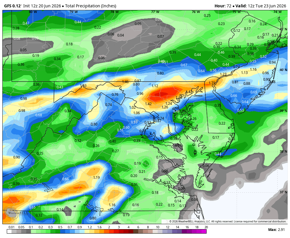
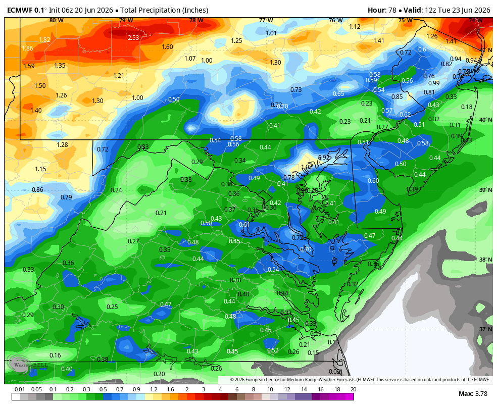
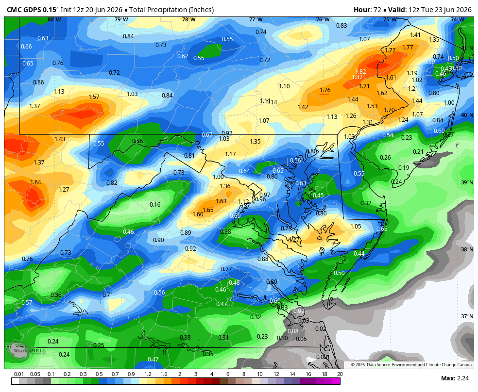
WB 12Z GFS, EURO, Can. And NBM (15Z).


-
Lots umbrellas flying at the beach today. Other then the wind it’s a 10/10 beach day. .
-
Ever seen Whiskey Treaty Roadshow?
-

2026-2027 Super El Nino
GaWx replied to Stormchaserchuck1's topic in Weather Forecasting and Discussion
Euro progging peak of impressive +1.4 Oct, which would beat 11/1997 record of +1.3! However, avg IOD has been rising with CC and thus in theory would need to be adjusted down to be comparable and would be < the +1.3 of ‘97. Otherwise, even the adjusted IOD prog could very well be 2nd strongest on record! IOD data back to 1870, which shows the ‘97 record and longterm rise: https://psl.noaa.gov/gcos_wgsp/Timeseries/Data/dmi.had.long.data -
The thing about a strong El Nino winter is that expectations are always high but reality can sometimes be a disappointment. 72-73 at +2.00 only gave Augusta County 3.0" of snow. 86-87 at +1.60 gave Augusta 52" of snow. 91-92 at +2.30 only gave Augusta 3.3" of snow. 09 - 10 at +1.50 average gave Augusta 63" of snow. The thing about 09-10 is that both the NAO at -2.00 and the AO at -3.50 were strongly negative. I think that was important.
-
Fantastic weather for the Green River Festival. Usually we get downpours or blazing heat. War and Treaty and Charley Crockett were killer last night. Kurt Vile, Spoon, Lucius, Geese and so much more coming up the next two days!
-

2026-2027 Super El Nino
snowman19 replied to Stormchaserchuck1's topic in Weather Forecasting and Discussion
-
2026-2027 Super El Nino
GaWx replied to Stormchaserchuck1's topic in Weather Forecasting and Discussion
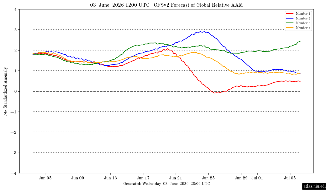
Further to my post above, the 0Z 5/25 fcast had a mean +3+ for now vs actual <+0.5! These like to overshoot severely: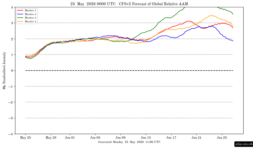
-

E PA/NJ/DE Summer 2026 Obs/Discussion
RedSky replied to PhiEaglesfan712's topic in Philadelphia Region
Super super El furnace Nino says no threats next winter - Today
-
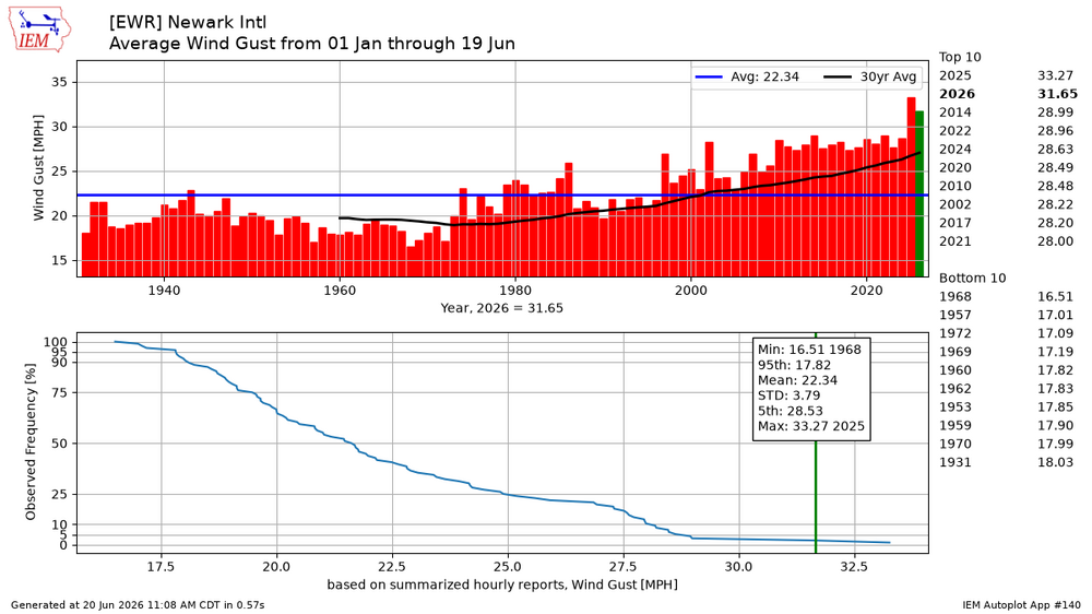
All these days with stronger wind gusts continue dry things out. 2026 is currently in 2nd place for the highest average wind gust through June 19th behind 2025. So this dry and windy pattern has been very persistent the last few years.
-
I noticed that. Some models throw off a little shower, maybe even a thunderstorm this afternoon and then again tomorrow too
-
I believe they have had some pretty hot wx over that way already this summer, and even Antarctica had very mild winter wx, too, for a couple weeks. And yet the Arctic is staying colder than normal with a persistent LP over the pack based on DMI data over the last month or so. Interesting tid bits.
-

Central PA Summer 2026 Discussion/Obs Thread
canderson replied to Voyager's topic in Upstate New York/Pennsylvania
Brightside: You have a diagnosis and can learn triggers and all and feel better going forward! -
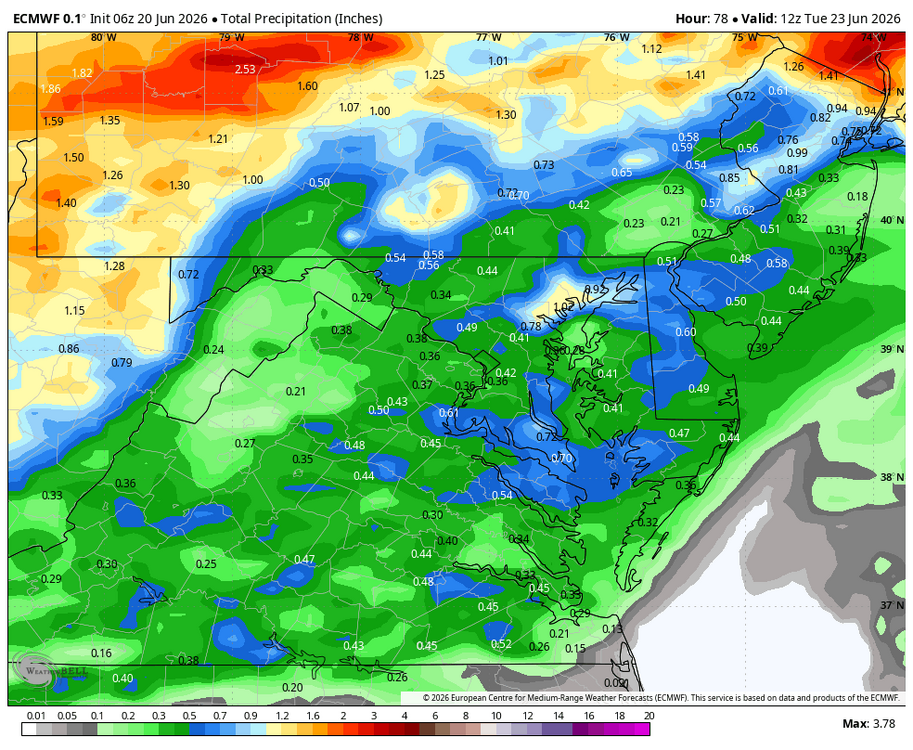
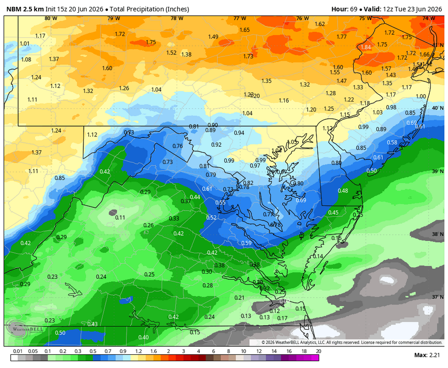
IMO there is going to be a wide range of totals in the region - anywhere from a few inches (where T-storms occur) to less than an inch in unknown areas.
-
I dont think its just convection. Looks pretty widespread and lasts 24 hours according to the gfs
-
The past week wasn’t hot or chilly. The DITINS ens nailed it.

-
Damn that really really sucks. Never want to rely strictly on convection. Even if you do get under decent convection with the ground parched it mostly runs off. We really want that strataform zone to trend south for a protracted soaking. .
-
Models throw me a bone later with maybe .25". especially the Canadians
-
June 20 1992: Abnormally cold conditions occur across the north. Temperatures drop to 26 at Embarrass, MN and Hayward, WI, but the cold spot is 24 at Brimson, MN. For Saturday, June 20, 2026 1682 - A major tornado ripped through southwestern Connecticut, passing through Stratford, Milford, and New Haven, and then into Long Island Sound. (Sandra and TI Richard Sanders - 1987) 1921 - Circle, MT, received 11.5 inches of rain in 24 hours, a record for the state. The town of Circle received a total of 16.79 inches of rain that month to establish a rainfall record for any town in Montana for any month of the year. (The Weather Channel) 1928 - A farmer near Greensburg, KS, looked up into the heart of a tornado. He described its walls as rotating clouds lit with constant flashes of lightning and a strong gassy odor with a screaming, hissing sound . (The Weather Channel) (Note: Just incredible, and a very rare occurrence) 1964 - A squall line producing large hail swept through central Illinois. A second squall line moved through during the early morning hours of the 21st, and a third one moved through shortly after dawn. The series of hailstorms caused nine million dollars damage. Hailstones as large as grapefruit caused heavy damage to trees, utility lines, crops and buildings. The thunderstorms also produced as much as five inches of rain in an eight hour period. (David Ludlum) 1987 - Thunderstorms prevailed east of the Rockies, producing severe weather in the Central High Plains Region. Thunderstorms spawned four tornadoes in Colorado, and produced wind gusts to 70 mph at Goodland, KS. (The National Weather Summary) (Storm Data) 1988 - Thirty-eight cities in the central U.S. reported record high temperatures for the date. Afternoon highs of 97 degrees at Flint, MI, and 104 degrees at Chicago, IL, equaled records for the month of June. Thunderstorms in North Dakota produced baseball size hail near Kief, and wind gusts to 100 mph near McGregor. (Storm Data) (The National Weather Summary) 1989 - An early morning thunderstorm produced wind gusts to 61 mph at Pierre, SD, and the hot thunderstorm winds raised the temperature from 86 degrees at midnight to 96 degrees by 1 AM, and 104 degrees by 2 AM. Butte, MT, and Yellowstone Park, WY, reported snow that afternoon. (The National Weather Summary) (Storm Data) Observances: (Note: Summer Solstice starts later today into tomorrow 0825 UTC.) 20 Sat Ugliest Dog Day 20 Sat American Eagle Day 20 Sat International Surfing Day 20 Sat World Juggling Day 20 Sat World Refugee Day 20 Sat West Virginia Day 20 Sat Summer Solstice 20 Sat Clear Your Drains Day 20 Sat National Celluma Light Therapy Day 20 Sat National Hike with a Geek Day 20 Sat National Ice Cream Soda Day 20 Sat National Vanilla Milkshake Day 20 Sat National West Virginia Day 20 Sat Nystagmus Awareness Day 20 Sat World Productivity Day
-
2026-2027 Super El Nino
GaWx replied to Stormchaserchuck1's topic in Weather Forecasting and Discussion
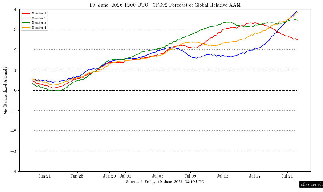
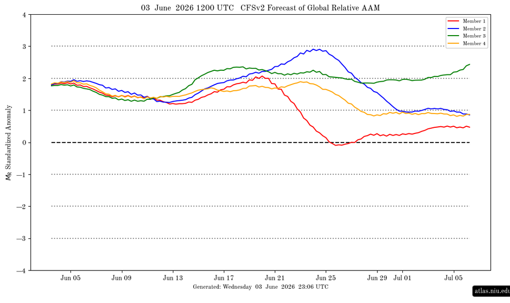
Keep in mind that these tend to run too high when forecasting extremes out several weeks: Note it’s now <0.5. Compare that to this 6/3 forecast, which had it at +2 for today!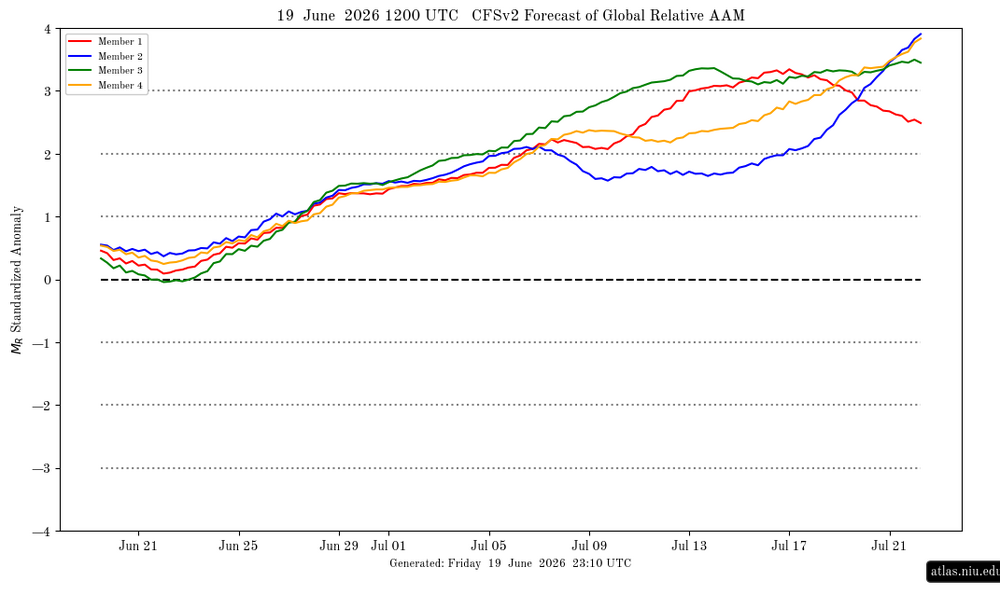
-
0.02" of rain in town yesterday. Not as chilly this morning with lows in the low 40's to low 50's. Highs around 70 today.