All Activity
- Past hour
-
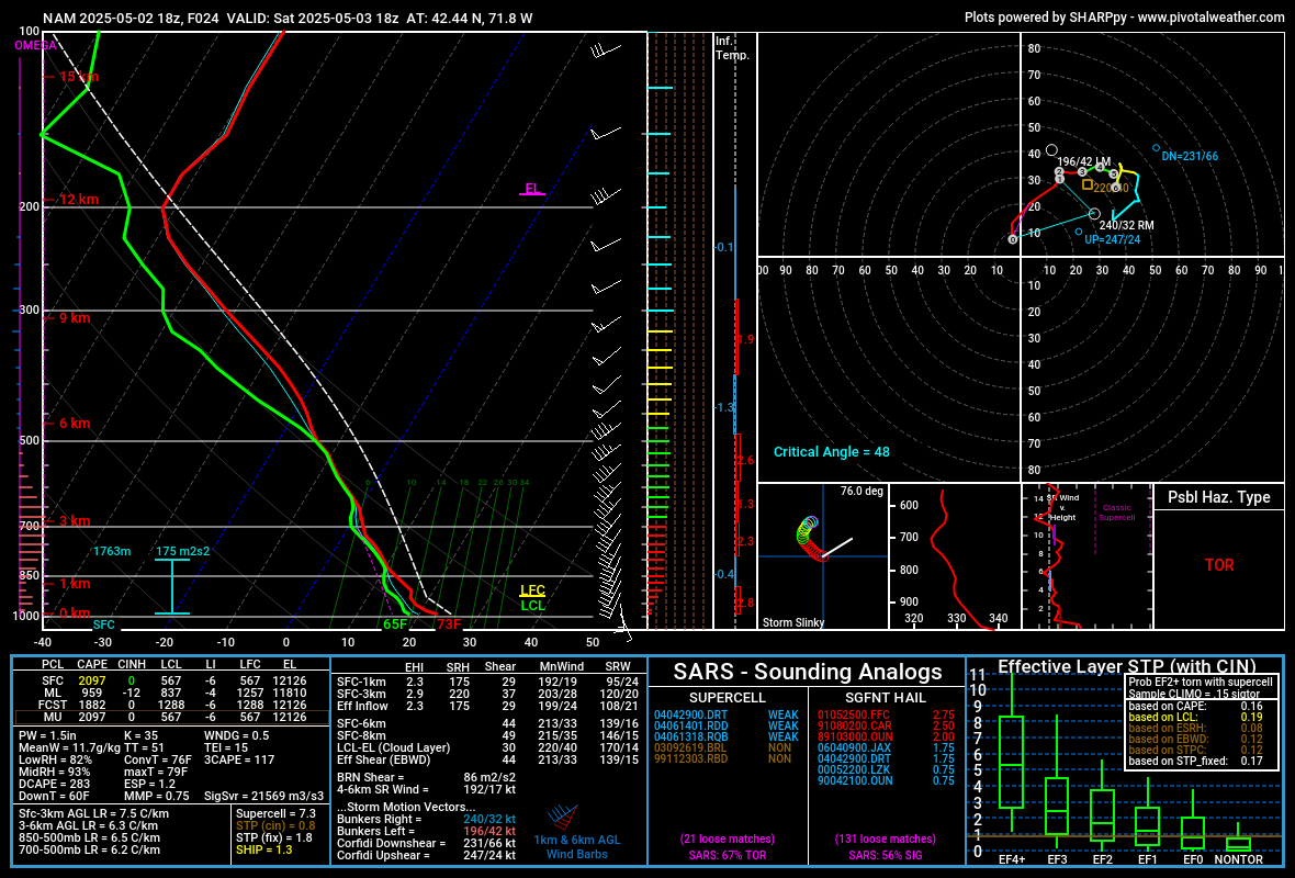
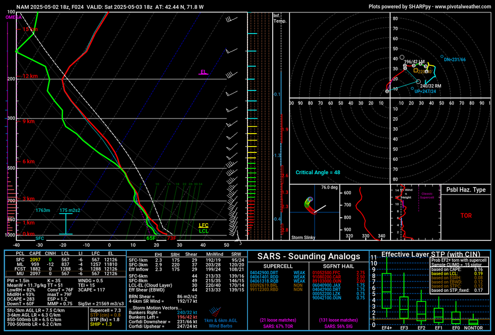
Weak tornado potential tomorrow?
-
Watching the radar thought the movement would bend more East with time, but it is continuing to move NE. Some sort of boundary ? Thought it might clip me. but not looking good.
-
That cell went right over the inner harbor.
-
Watch out boaters in the upper Bay Special Marine Warning ANZ530-531-022300- /O.NEW.KLWX.MA.W.0044.250502T2137Z-250502T2300Z/ BULLETIN - IMMEDIATE BROADCAST REQUESTED Special Marine Warning National Weather Service Baltimore MD/Washington DC 537 PM EDT Fri May 2 2025 The National Weather Service in Sterling Virginia has issued a * Special Marine Warning for... Chesapeake Bay from Pooles Island to Sandy Point MD... Chesapeake Bay north of Pooles Island MD... * Until 700 PM EDT. * At 536 PM EDT, strong thunderstorms were located along a line extending from near Middle River to Back River, moving east at 15 knots. HAZARD...Wind gusts 34 knots or greater. SOURCE...Radar indicated. IMPACT...Boaters in small craft could be thrown overboard by suddenly higher winds and waves capsizing their vessel. * Locations impacted include... Turkey Point, Hart Miller Island, Gunpowder River, Northeast River, Worton Point, Pooles Island, Spesutie Island, Aberdeen Proving Ground, and Havre De Grace. PRECAUTIONARY/PREPAREDNESS ACTIONS... Move to safe harbor until hazardous weather passes
-
Temperatures soared into the 80s across the region today. New York City's high temperature was 84°. Tomorrow will be another unseasonably warm day. Highs tomorrow will likely reach the lower 80s in New York City and mid 80s in the warmest spots. Afternoon or evening thunderstorms are possible as a cool front drifts across the region. Behind the front, it will turn somewhat cooler on Sunday. A wet pattern is likely Sunday through Wednesday. A significant rainfall is possible, but there remain large differences among the computer models. The European Model is most aggressive in showing 5" or more rainfall. An early estimate of a general 1"-3" total with locally higher amounts during the Sunday-Wednesday period looks reasonable. The ENSO Region 1+2 anomaly was -0.3°C and the Region 3.4 anomaly was 0.0°C for the week centered around April 23. For the past six weeks, the ENSO Region 1+2 anomaly has averaged +0.82°C and the ENSO Region 3.4 anomaly has averaged -0.05°C. Neutral ENSO conditions will likely continue through at least early summer. Early indications are that summer 2025 will be warmer than normal in the New York City and Philadelphia areas. The potential exists for a much warmer than normal summer (more than 1° above normal). The SOI was -4.65 today. The preliminary Arctic Oscillation (AO) was +0.977 today.
-
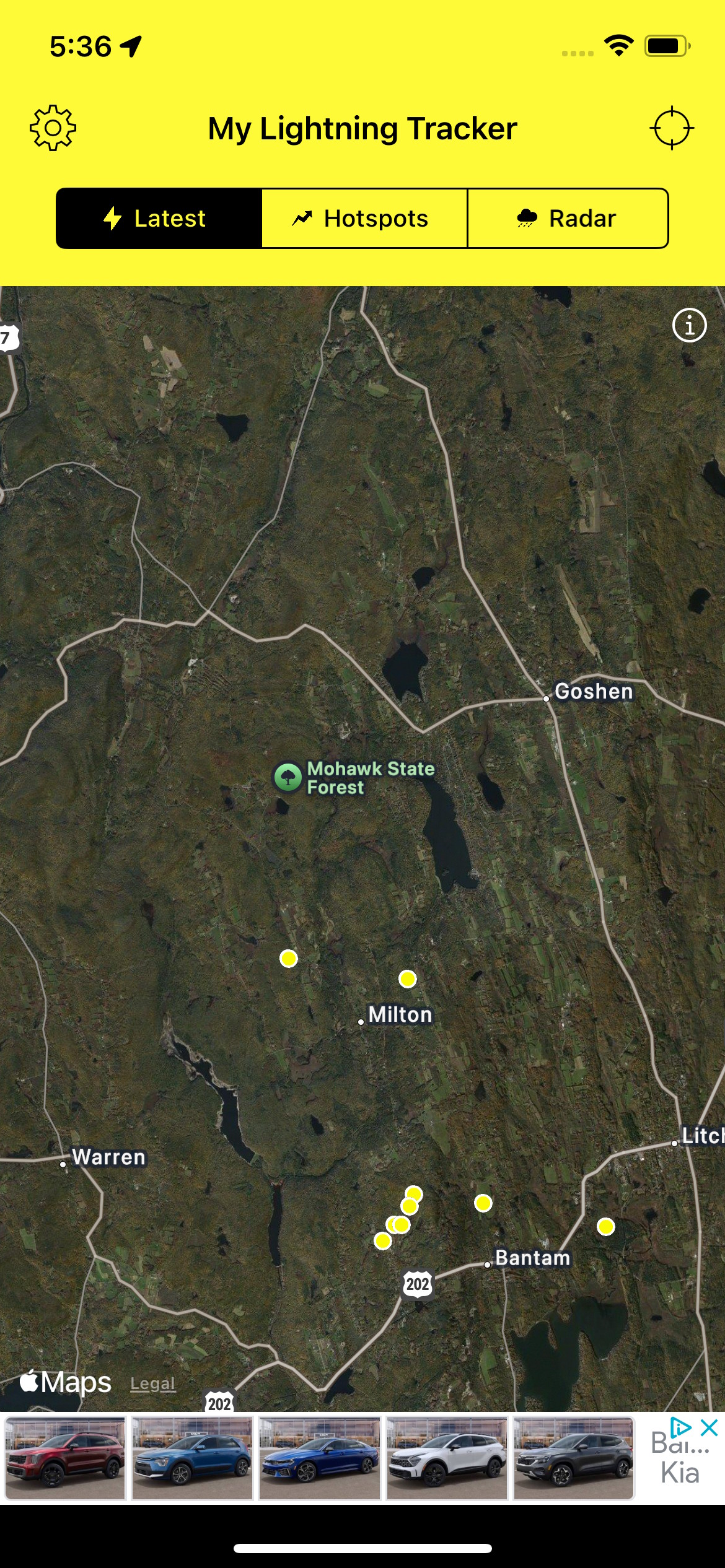
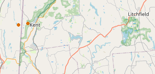
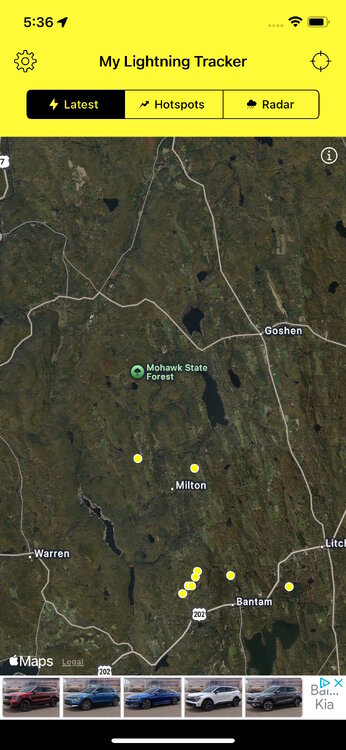
Yeah, well, um... lightningmaps.org shows a couple of lonely dots in or around the town of Kent. The My Lightning Tracker app shows a cluster to the east of that. Those two sources never seem to agree on the details, but they do seem to get the general gist right.
-
Made it up to 87 in the last hour
-
Muggy and low 70s a few miles inland from the water. Today definitely was the first day we had that real warm season feel.
-
Beer?
-
My lightning app says that I missed a bunch of activity in my neighborhood or just a bit north about a half hour ago. Heard a rumble or two, but thought it was a truck. (!) The ground is wet - didn't notice any rain.
-

E PA/NJ/DE Spring 2025 Obs/Discussion
Albedoman replied to PhiEaglesfan712's topic in Philadelphia Region
Blue mts deztroyed storms again tonight. Forecast is becoming doubtful now -
Long Island spring. 20-30 degree differences around the island
-
0.00" of drought busting thus far.
-
0.1-0.2” from phase 1 of the drought busting
-
depends ... the epo is won't day in the baseline GEFs ... it's not the same implication as January, no. but, we can still get these blocking nodes well into June some years... -epo is can set that table. I'm a little leery of those ice cubes in the warm punch. but yeah, otherwise, both it and the EPS longer lead telecons are an endlessly negative PNA mode, and the AO's seasonally ko'd
-

2025 Lawns & Gardens Thread. Making Lawns Great Again
Brewbeer replied to Damage In Tolland's topic in New England
there are some parts of my yard I can get away with doing this and I'm going to try it -
Crazy winds and sideways rain, lasted for about 5 minutes. Oak pollen strands clogged my gutters up good!
-
There are currently about 50 active severe Tstrom warnings. The map is wild.
- Today
-
I'm guessing you meant to type 0.27? That's believable and still pretty impressive.
-
The storm that went over MBY cooled me down from 85ish down to 66. It's already back up to 70 now with the sun back out. Dewpoint is steamy...
-
The wind was pretty solid during the downpour. Ended up with 0.10
-
That's south jersey, lol Hot as balls and windy here
-
Feeling good enough for the Phils game you mentioned? I hope so!
-
Looks like we setting up for a very warm second half of the month. Once we get past this upcoming week it's off to the races.
-
Great, t-storm incoming just as we are leaving for OPACY.