All Activity
- Past hour
-

January 2026 regional war/obs/disco thread
dendrite replied to Baroclinic Zone's topic in New England
What’s your reasoning for 2? -

January 2026 regional war/obs/disco thread
Krs4Lfe replied to Baroclinic Zone's topic in New England
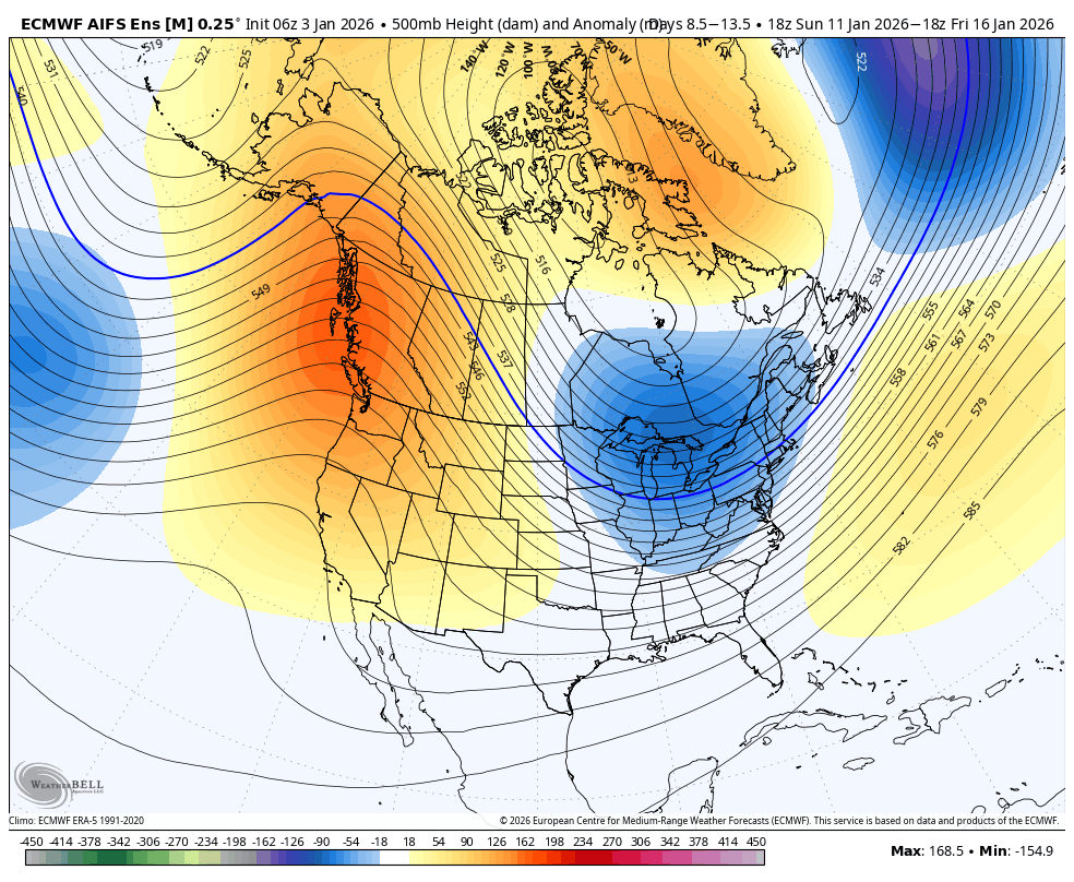
Ideally, you would want the ridge closer towards Idaho and Utah, which would force deeper anomalies closer to the east coast as opposed to a deeper trough in the Great Lakes, which can usually signal more clippers and a fast northern stream. Either way it’s a lot better than what will be in place next week and it doesn’t seem to be being pushed back at all. -
January 2026 regional war/obs/disco thread
Krs4Lfe replied to Baroclinic Zone's topic in New England
I’ll probably blow torch for a week, especially here closer to the mid Atlantic. The models are generally honing in on a pattern change around the 11th or the 12th but obviously we should not expect any immediate chances for snow because the pattern change will have to set in first before the chances actually come. Hopefully that pattern changes here to stay because with a properly timed SW during cold anomalies in January, which is already peak Climo, we could do very well. -

Winter 2025-26 Medium/Long Range Discussion
Baum replied to michsnowfreak's topic in Lakes/Ohio Valley
Yup. Just had a week of pure winter. 20’s and two dusters. Long long way to go in these parts. Of course, if your banking on endless days of cold and snow that rarely happens in these parts. Seen winters where the first real snow didn’t hit until a foot on the last day of January. Actually going to enjoy the 40’s and hopefully a salt washer at weeks end. Probably, snow 20” after next week to close out the month. -
.01 with a low of 44 last night.
-
Appropriate music here:
-
Picked up an inch and a half of rain last night. Looking like more needed rainfall next weekend too. If we cant have cold/snow, I will gladly take the needed rainfall.
-
Dry begets dry, wet begets wet. And snow begets snow. While in theory it’s improbable, we could nearly have a shut out for most of rest of winter because we clearly lack a coastal track. Hard to nickel and dime our way to seasonal average in these parts. Absent a KU and it’s almost impossible to get to seasonal average
-
Cold morning putting out recycling. The wolf-moon was going down as the sun was up; awesome sky to see.
-

January 2026 regional war/obs/disco thread
Sey-Mour Snow replied to Baroclinic Zone's topic in New England
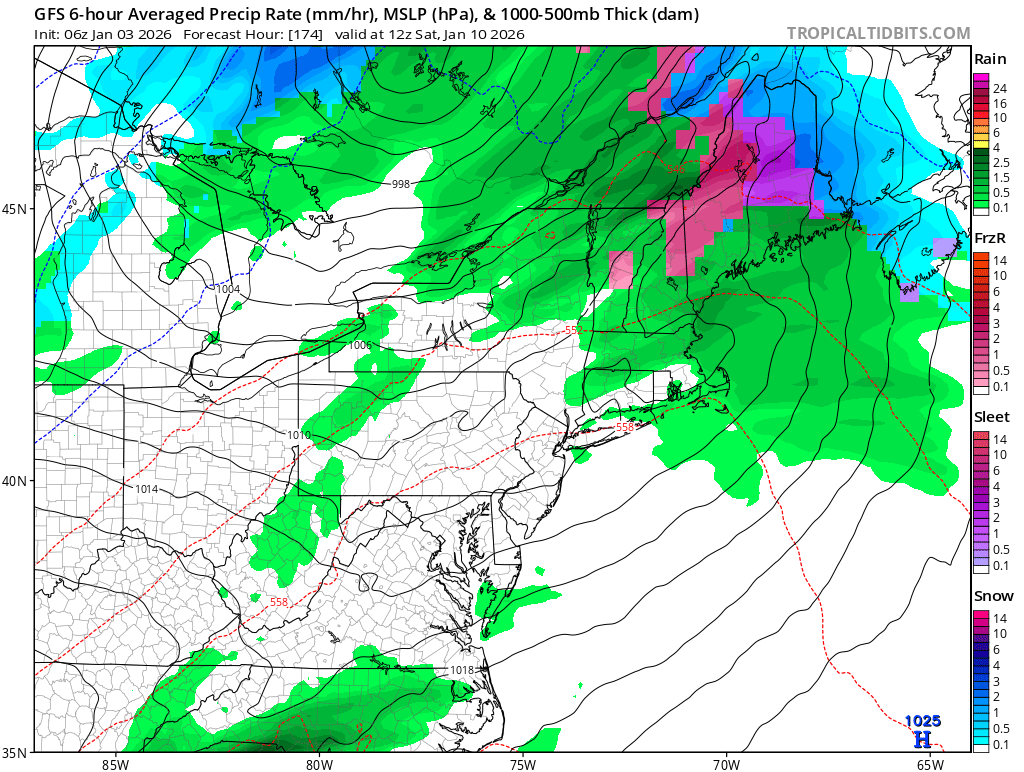
It's really just that one bad cutter Friday/Saturday.. As CNE/NNE are in the game for mid week. Jan 11-17 look like this on pretty much all ensembles, so much more confidence than the fake -NAO modeled last week .. I'm optimistic on this look, hoping for a little coastal action, but we will see if this look actually plays out.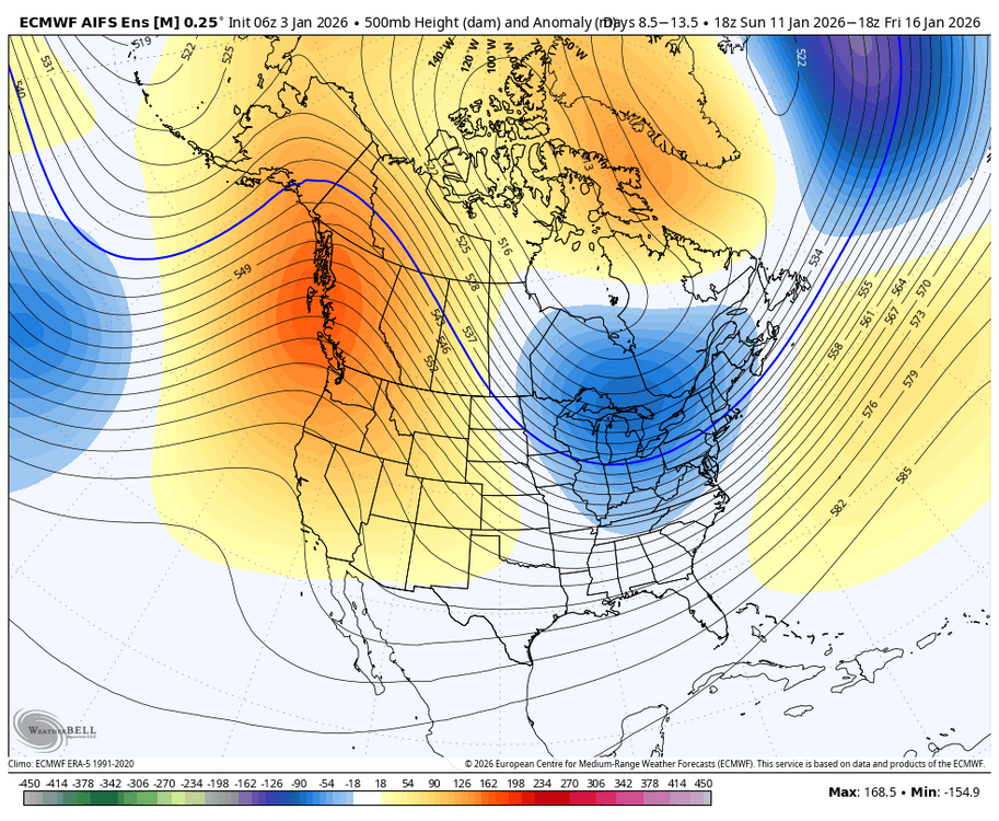
-

January 2026 regional war/obs/disco thread
Damage In Tolland replied to Baroclinic Zone's topic in New England
NWS? -

January 2026 regional war/obs/disco thread
qg_omega replied to Baroclinic Zone's topic in New England
Looks great for NNE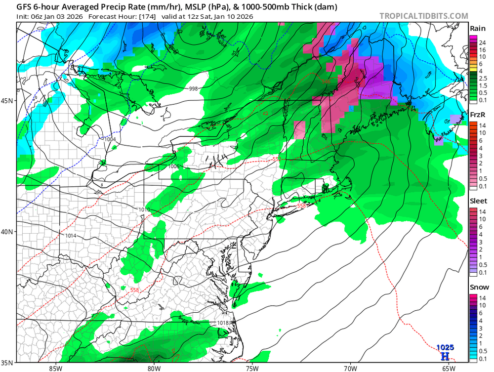
-

January 2026 regional war/obs/disco thread
CoastalWx replied to Baroclinic Zone's topic in New England
Just calling it as I see it. Looks like poopie until mid month or so. Obviously a little better up in NNE. -
Significant cooling of all three major non-AI ensembles overnight. Looks to me like a very normal and cold EPO look. Ensembles trended away from putting the trough out West.
-
They ruined the ACC vs pre-90's teams. Incredible watching games from the mid-late 70's until early 90's.
-

New Years Day 2026 - 1st snows of the new year possible
codfishsnowman replied to Baroclinic Zone's topic in New England
1.3 new...11.1 season great start....a little penny and nickley.....looking for some dimes and quaters -
This ties in with the very persistent trend of dry/drought we’ve seen since the tail end of summer, 2024 you just posted about. The most persistent dry pattern we’ve seen in this region in over 24 years. Every time it’s looked like we are going to go into a wet pattern again, it fails
-
January 2026 regional war/obs/disco thread
codfishsnowman replied to Baroclinic Zone's topic in New England
So much for that short last week about East Coast storminess and blocking and snowstorms up and down the eastern seaboard that I saw a few days ago on YouTube -
Gefs looks cold too
-
Maybe a blip, but 6z GEFS is a big change in a more positive direction for us. Much deeper -NAO/-AO and it keeps a trough in the east until the very end of the run, when it’s still a very workable gradient pattern.
-
Here bro. Use this map. It dosent have a global warning agenda
-

January 2026 regional war/obs/disco thread
Spanks45 replied to Baroclinic Zone's topic in New England
Currently -1.7⁰, finally made it below zero....I'm ok with a January thaw now with hopefully snow mid to late month. In a few short weeks I will be starting some seeds for the coming garden season. -
The way we got our snowfall this past December was different from the previous cold and snowy Decembers. This was our first December since at least 1950 with two 4-8” snowfall clippers. Past snowy Decembers into early January had big KU systems with widespread snows over 10”. The models backing off the coastal system which was forecast for next week is telling us that the Northern Stream is still dominant. We haven’t had a widespread 25”+ season from EWR-NYC-LGA-JFK-ISP in over 30 years without at least one KU NESIS Cat 1 event or higher. The other thing is that all our recent winters since 21-22 had most of the seasonal snowfall focused into just one winter month. This is why I am concerned that absent a revival of the BM coastal storm track before this winter is over, that December will be our snowiest winter month this year and most spots from EWR to ISP finish with another below average snowfall season. Since it was something like a 50 year+ event to get two 4-8” snowfall clippers in a two week period in December. That really productive clipper pattern for snow has shifted and we still haven’t seen evidence for a big KU pattern developing. Whatever happens, this was our best December in terms of cold and snow in a long time which we are all very grateful for.
-

Central PA Winter 25/26 Discussion and Obs
Voyager replied to MAG5035's topic in Upstate New York/Pennsylvania
You and me both. -

Central PA Winter 25/26 Discussion and Obs
mahantango#1 replied to MAG5035's topic in Upstate New York/Pennsylvania
Remember the last forecast warmup around Christmas, and what transpired? Hope they're right this time.