All Activity
- Past hour
-
82 and humid already at 11 am. Think we blow past the forecast high of 86. Hit 88 yesterday, with a forecast high of 84. Its definitely been a bit cooler in my area, but nothing like what it was supposed to be. I am hopeful the next cool blast Monday materializes for us.
-

2025-2026 ENSO
PhiEaglesfan712 replied to 40/70 Benchmark's topic in Weather Forecasting and Discussion
If Nino 1+2 does not return to an el nino state, then this winter will have a more la nina feel to it. Last year felt like a tug-of-war between the la nina in 3.4 and the el nino in 1+2. It certainly did not behave like a la nina. -

September 2025 OBS-Discussion centered NYC subforum
MANDA replied to wdrag's topic in New York City Metro
Invest 91L just designated for Atlantic wave. -
We have Invest 91L in the eastern Atlantic.
-
RONI-ONI differences have been slowly dropping since late in 2024 and especially since FMA: 2024: JJA -0.54 JAS -0.52 ASO -0.54 SON -0.55 OND -0.55 NDJ -0.54 DJF -0.53 2025: JFM -0.51 FMA -0.49 MAM -0.43 AMJ -0.38 MJJ -0.32 JJA -0.29
-
Let’s goooo 12z 3k NAM!
-
Are we jumping the gun on the ENSO state being La Niña? No
-
Heat Island kept MSP at a relatively mild 46 overnight.
-

Occasional Thoughts on Climate Change
Typhoon Tip replied to donsutherland1's topic in Climate Change
Curious what the previous record was -
If we get one it’ll be weak. There will be other factors at play that’ll determine what kind of winter we get.
-
Stein coming at us in all directions.. crushing everything as he moves in
-
2025-2026 ENSO
PhiEaglesfan712 replied to 40/70 Benchmark's topic in Weather Forecasting and Discussion
It looks like the ONI and RONI are converging: JJA 2025 ONI (NOAA): -0.2 JJA 2025 RONI: -0.46 August 2025 PDO: -3.23 (July 2025 PDO was adjusted to -4.12) If the el nino happens in 2026-27, I can only see it going weak or moderate. If it happens in 2027-28, it will be much stronger with the extra year to develop. (I mean, it's no surprise the 15-16 el nino was very strong because of the extra 3 years it had to develop. It didn't happen in 12-13 as most people thought, or even 14-15.) -
It seems like people are pretty much already set on a niña? Are we jumping the gun?
-
What look do you get with the combined QBO Status ?
- Today
-
Big cold front coming in this weekend.
-
Had a low of 56 with guess what more rain this morning.
-
@buckeyefan1or @Mr Bob will you pin this thread and unpin our summer thread? Thank you in advance.
-
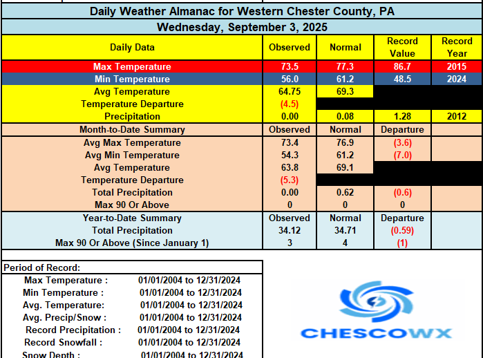
We should see our 1st above normal temperature day in 17 days today for many areas. A couple of cold fronts the first weak this evening and the next one on Saturday is stronger. Each of these may bring some much-needed rain. In fact, the National Weather Service has much of Chester County with between 0.75" to 1.00" of much needed rain by Sunday morning. Behind that front we turn much chillier again by Sunday night with a return to below normal temperatures with lows in the 40's and highs in the low 70's next week.
-

E PA/NJ/DE Summer 2025 Obs/Discussion
ChescoWx replied to Hurricane Agnes's topic in Philadelphia Region
We should see our 1st above normal temperature day in 17 days today for many areas. A couple of cold fronts the first weak this evening and the next one on Saturday is stronger. Each of these may bring some much-needed rain. In fact, the National Weather Service has much of Chester County with between 0.75" to 1.00" of much needed rain by Sunday morning. Behind that front we turn much chillier again by Sunday night with a return to below normal temperatures with lows in the 40's and highs in the low 70's next week.
-

September 2025 OBS-Discussion centered NYC subforum
Stormlover74 replied to wdrag's topic in New York City Metro
Hopefully most places west of nyc can squeeze out a quarter inch tonight.thumb.png.91c71019c3f2dcd873bc24c685e240cf.png)
.thumb.png.feebd38ed140bf28f917c143d30b3755.png)
-
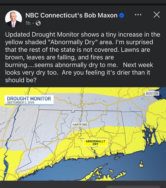
Starting to see some drought showing up finally. I've only received about 1/2 of an inch since late July. Needless to say, lawns are quite brown and dormant, with some premature leaf droppage.
-

2025-2026 Fall/Winter Mountain Thread
Buckethead replied to Buckethead's topic in Southeastern States
58° with moderate rain this morning in South Toe. 54° at my house in Wolf Laurel. Sent from my SM-S908U using Tapatalk -
-
This thread is for forecast discussions and speculation regarding the upcoming winter.
-

2025 Spring/Summer Mountain Thread
BlueRidgeFolklore replied to Maggie Valley Steve's topic in Southeastern States
Let's Go!!!!


.png.15f396cb1813dc93f639ade083e10a22.png)
.png.96227111ab93324922597cf99f2d4ca7.png)

