All Activity
- Past hour
-
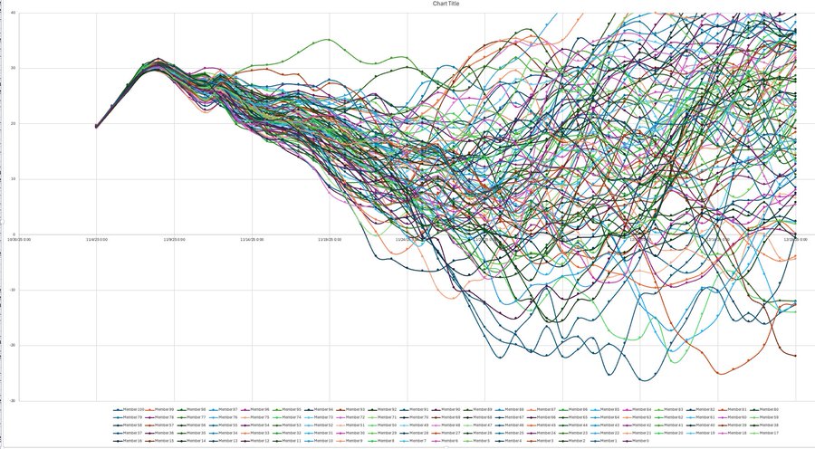
Allan Huffman @RaleighWx Some chatter in the long range about a SSWE. Here was yesterdays 00z EC46 10mb U forecast. Lots of squiggly lines but in looking at the raw data, 45 of the 100 EC46 members show at least 1 day with a -U (reversal) between now and 12/19with 12/1 the day with the most members with a negative value. If a SSWE occurs, it CAN increase the risk for high latitude blocking (-AO) and increased risk for discharge of arctic air into the mid latitudes, usually 1-2 weeks after the reversal. Just an interesting item to monitor.
-
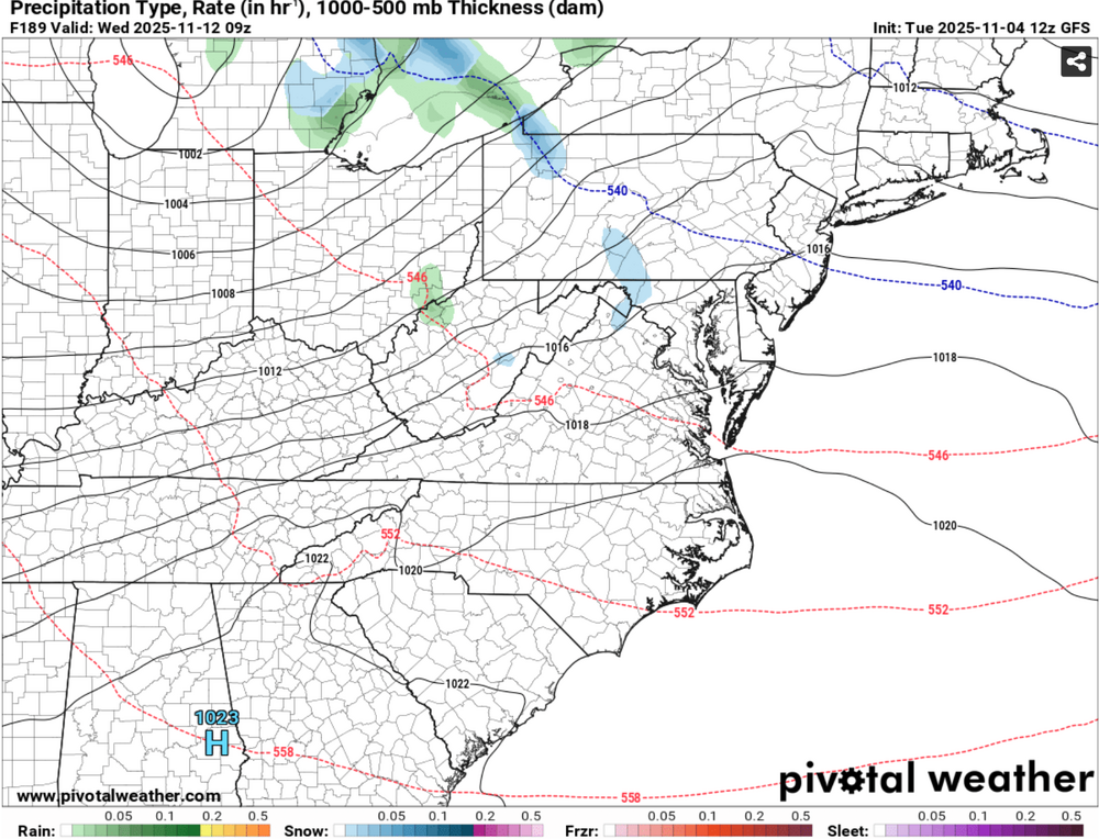
GFS paints a snow flurry next Wednesday. This GFS rub seems to show a few more cooler shots after brief warm ups, but not as dramatic as next week. At the end of the run it looked like warmth was coming, but it is way out there.
-
Nice, FIRE UP, class of 08 here.
-
@GaWx, one thing I did notice regarding the SSW discussion you all are having. Anytime we see an EC ridge hook into AN heights over Greenland, I have observed the stratosphere get hammered. I actually tried looking at the Weeklies for strat anomalies, but wxbell doesn't have it I don't "think." I tried looking due to the ridge that is forecast to roll through mid November. If it connects into those heights in Greenland....that is when I notice SSWs occur. I notice it also when a WAR does the same. That would completely shakeup up LR ext modeling if it occurs partially or in full. Great disco. I will drop a link below. Great discussion... @Daniel Boone
-
 Where's Ineedsnow's requisite ICON post?
 -
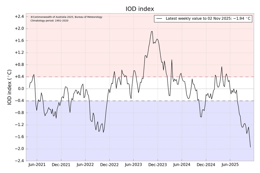
Uncharted territory here with this new record negative IOD.
-
@GaWxgot a mention on JB's blog today. Awesome stuff. It is regarding the 50mb PV displacement which is much earlier than normal.
-

November 2025 general discussions and probable topic derailings ...
Lava Rock replied to Typhoon Tip's topic in New England
time for wegovy -

Central PA Fall Discussions and Obs
Mount Joy Snowman replied to ChescoWx's topic in Upstate New York/Pennsylvania
I hear ya both, although my big issues has always been falling asleep. Terrible at it. Will lay there for hours sometimes before I can go down. -
 Even with the lack of acorns here, the squirrels are very fat.
 -
And so it begins (on the MN Deer Hunting opener) on Sat. YAH U Betcha! Saturday A chance of snow, mainly after noon. Mostly cloudy, with a high near 37. Calm wind becoming southwest around 5 mph in the morning. Saturday Night A slight chance of snow before midnight. Mostly cloudy, with a low around 22. Northwest wind 5 to 10 mph, with gusts as high as 20 mph. Sunday A chance of flurries. Partly sunny, with a high near 36. Northwest wind around 10 mph, with gusts as high as 20 mph. Sunday Night Partly cloudy, with a low around 20. Northwest wind 5 to 10 mph, with gusts as high as 20 mph. Monday Mostly sunny, with a high near 36. Northwest wind 5 to 10 mph.
-
 That be some hurricane gusts a blowin!
 -
Records: Highs: EWR: 79 (1994) NYC: 78 (1975) LGA: 76 (1987) JFK: 77 (1975) Lows: EWR: 26 (1951) NYC: 25 (1879) LGA: 29 (1951) JFK: 34 (2019) Historical: 1927 - A great Vermont flood occurred. Tropical rains deluged the Green Mountain area of Vermont causing the worst flood in the history of the state. Torrential rains, up to 15 inches in the higher elevations, sent streams on a rampage devastating the Winooski Valley. Flooding claimed 200 lives and caused 40 million dollars damage. The town of Vernon reported 84 deaths. Flooding left up to eight to ten feet of water in downtown Montpelier VT. (2nd-4th) (David Ludlum) (The Weather Channel) 1935: Called the Yankee Hurricane, this Category 2 storm affected the Bahamas and South Florida. The storm remains the only tropical cyclone to hit Miami from the Northeast in November. 1940: The longest period with no snow at 200 days ended on this date at Denver, CO with the first snow of the season, a trace. The last snow prior was on 4/17/1940. (Ref. Wilson Wx. History) 1959: A rare F0 tornado caused minor damage near Cape St. Elias Light Station on Kayak Island, Alaska. 1970: An F2 tornado touched down during the afternoon in Atlantic County, New Jersey. An intense hailstorm at Point Pleasant Beach, NJ produced significant accumulation. (Ref. Wilson Wx. History) 1982: The five day long heat wave along the east coast came to an abrupt end with the passage of a strong cold front. For the previous five days, a strong ridge of high pressure moved from the Midwest across the Ohio Valley to off the east coast. Temperatures warmed into the 70’s all the way into New England and the low 80’s to Philadelphia. Record highs for the date included: Vero Beach, FL: 87°, Newark, NJ: 77°-Tied, Burlington, VT: 73° and Caribou, ME: 66°. (Ref. Wilson Wx. History) 1985 - A super wet Gulf storm dumped upwards of fifteen inches of rain in the mountains of Virginia and West Virginia causing devastating damage and claiming forty lives. (Sandra and TI Richard Sanders - 1987) 1985: Heavy rains from the remnants of tropical storm Juan dropped 10 to 19 inches of rain on West Virginia and surrounding states, causing 62 deaths. A maximum rainfall amount of 19.77 inches was recorded near Montebello in the Blue Ridge Mountains in Virginia. The flood in West Virginia was considered the worst in the state’s history. 1987 - Thirty-two cities in the eastern and south central U.S. reported record high temperatures for the date. Highs of 74 degrees at Portland ME and 86 degrees at Fort Smith AR equalled November records. It was the fourth day of record warmth for Beckley WV, Memphis TN and Paducah KY. A cold front ushered much colder air into the north central U.S. Gale force winds lashed all five Great Lakes. (The National Weather Summary) 1988 - Thunderstorms developing ahead of a fast moving cold front produced severe weather over the Tennessee Valley and the Central Gulf Coast States during the afternoon and evening hours, and into the next morning. Thunderstorms spawned nineteen tornadoes, including eleven in Mississippi. The last of the nineteen tornadoes killed a woman in her mobile home in Lee FL. A tornado in Culbert AL injured sixteen people, and caused two million dollars damage. Thunderstorms also produced baseball size hail in Alabama. Unseasonably hot air prevailed south of the cold front. McAllen TX was the hot spot in the nation with a high of 102 degrees. (The National Weather Summary) (Storm Data) 1989 - Snow and high winds plagued parts of Colorado and Wyoming. Winds gusted to 71 mph near Wheatland WY, and reached 80 mph west of Fort Collins CO. Up to five inches of snow blanketed Yellowstone Park WY closing many roads. Snow also blanketed northern Minnesota, with seven inches reported at Baudette. (The National Weather Summary) (Storm Data) 1991: Record cold continued to prevail from the Rockies to the Southeast as cold high pressure built in behind the Halloween Meg-Storm. Record low temperatures were set at: Alamosa, CO: -13°, Norfolk, NE: -9°, St. Cloud, MN: -9°, Sioux Falls, SD: -6°, Lincoln, NE: -4°, Grand Island, NE: -3°, Sioux City, IA: -3°, Minneapolis, MN: -3°, Aberdeen, SD: -2°, Lander, WY: -2°, International Falls, MN: -2°, Rochester, MN: -2°, Valentine, NE: 0°, Huron, SD: 0°, Springfield, MO: 10°, Moline, IL: 10°, Rockford, IL: 10°-Tied, Chicago, IL: 11°, Elkins, WV: 11°, Columbia, MO: 13°, Akron, OH: 13°, Cincinnati, OH: 16°, Cleveland, OH: 16°, Columbus, OH: 18°, Lexington, KY: 18°, Charleston, WV: 21° and many other cities. (Ref. Wilson Wx. History) 2000: A record streak of days with no rain finally ends... The string of days with no precipitation has finally ended at some sites in North Carolina. One example of this is Raleigh and Durham. The Raleigh and Durham International Airport received 0.01 of an inch of rain November 4th 2000 Saturday evening between 6 and 7 p.m. This was the first measurable rain since September 26, 2000 when 0.03 of an inch of rain fell. The 38-day streak was the longest on record at the site breaking the 32-day record set from November 23 to December 24, 1965. (Ref. Wilson Wx. History) 2001: Hurricane Michelle was only the 5th November major hurricane in the Atlantic. At its peak intensity on the 3rd, the Category 4 hurricane had top winds of 135 mph. Hurricane warnings were in effect for Cuba on the 3rd as the island braced for its worst hurricane since 1944. The storm weakened before landfall, but Cuba suffered significant damage to crops and infrastructure, especially the important sugar cane crop that was ready for harvest. Fortunately, the hurricane missed major cities and crossed less inhabited agricultural areas. (Ref. Wilson Wx. History)
-
November 2025 general discussions and probable topic derailings ...
Lava Rock replied to Typhoon Tip's topic in New England
gotta be rocking and rolling at BOS and PWM for departures/arrivals. -
59 / 28 sunny. Looks like Wed / Sat will be the warmest of the next week or 2. Wed could see some upper 60s and the warmest spots making a run on 70. Trough and stronger below normal coming 10th - 12th before moderating back to and above normal. 11/4 - 11/9 : Near - above normal - cloudier weekend w/ showers rain- light 11/10 - 11/12 : Coldest of the season fist freezes 11/13 - beyond : moderating back to / above normal
-

Correlation of extreme hurricanes, AGW, and solar cycles
GaWx replied to WolfStock1's topic in Climate Change
No, the overall heat from the sun does not decrease when sunspots increase; the total solar energy output actually increases slightly during periods of high sunspot activity. This happens because sunspots, though cooler and darker, are surrounded by brighter, hotter areas called faculae (or plages). The increased brightness from the faculae outweighs the slight dimming from the sunspots themselves, resulting in a net increase in the sun's total energy output. From an inquiry of AI via Google of the following: Does overall heat from sun decrease when sunspots increase? ———— So it’s a net increase. Solar flux increases. -
 Good thing peak winds at 900-925 occur when its dark, if this came through 12-18 hours later I think some gusts over 50 would be possible.
 -
 37 mph in Muttontown already & 31 mph in Syosset.
- 4 replies
-
- 1
-

-
- wind damage
- power outages
- (and 1 more)
-
Like what I’m seeing on the models for tomorrow/Thursday am, though SLK may not have enough elevation.
-

November 2025 general discussions and probable topic derailings ...
Layman replied to Typhoon Tip's topic in New England
We're heading up to your neck of the woods tomorrow for a few days to stay at the Omni. Looks like we'll get our first taste of some snow! And wind...lots of wind. The red squirrels were out in force during the spring and early summer here. Bold and trying to get into everything! -
Normally I would say it's not permanent because weather patterns change quite often. But with the background state of the climate, I think climate change has made the WestPac so warm (which enhances the PacJet and causes west coast storminess and only transient troughs in the east at best), that there's no turning back. I think more of us will come along to this idea towards the end of the decade if we continue to see lack of snow in the area. In the past, decades with low snowfall amounts could be attributed to periods of drier weather or transient year-to-year weather pattern changes. But since late 2010s, we've been in a generally low amount of snowfall (save for a few winters) because it's just too warm to snow.
-
NW flow chances just keep looking better next week. Nice little piece of energy keeps digging into the base of that trough on the models.
-
The jury is out on whether or not CC is bringing down/will bring down average lifespans. Why? -If we assume CC significantly increases food supply via larger crops, that markedly reduces deaths related to malnutrition. That’s huge! -Cold has historically been a bigger killer than heat although that eventually might even out way down the road. -Sea level rises are gradual. Thus a lot of the death potential from it can easily be mitigated by moving to higher ground. -When considering all of the above, CC may actually (continue to) result in increased average life spans with increased deaths from heat/flooding/more intense hurricanes notwithstanding.
-
yessir!


.thumb.jpg.ad3a2e31d30aff035044689b311a0540.jpg)