All Activity
- Past hour
-
True. They are lucky. And they are snowier than many places further north. In fact id assume they are snowier than the banana belt of the UP even. Its a little microclimate.
-

December 14th - Snow showers or Plowable snow?
Damage In Tolland replied to Sey-Mour Snow's topic in New England
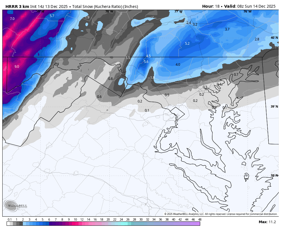
Looks to me like 2-4 most of state north of 95 and 3-6” south. Exception CTRV north of HFD with 1” -
I'm convinced it's a dna hardwired trait. I was obsessed with snow when I was 2 and my parents didn't care for it all that much. There was no conditioning and I was too young to understand science. Simply born this way... for better or worse... probably worse
-
I enjoy reading your posts, thanks.
-
Agree...
-
that band is looking good for Mount Fort Reno here in the alpine region of NW Washington.
-

12/14: Sunday funday? Will the south win again?
winter_warlock replied to TSSN+'s topic in Mid Atlantic
Stranger things have happened bro! -
i approve lol
-

12/14: Sunday funday? Will the south win again?
Weather Will replied to TSSN+'s topic in Mid Atlantic
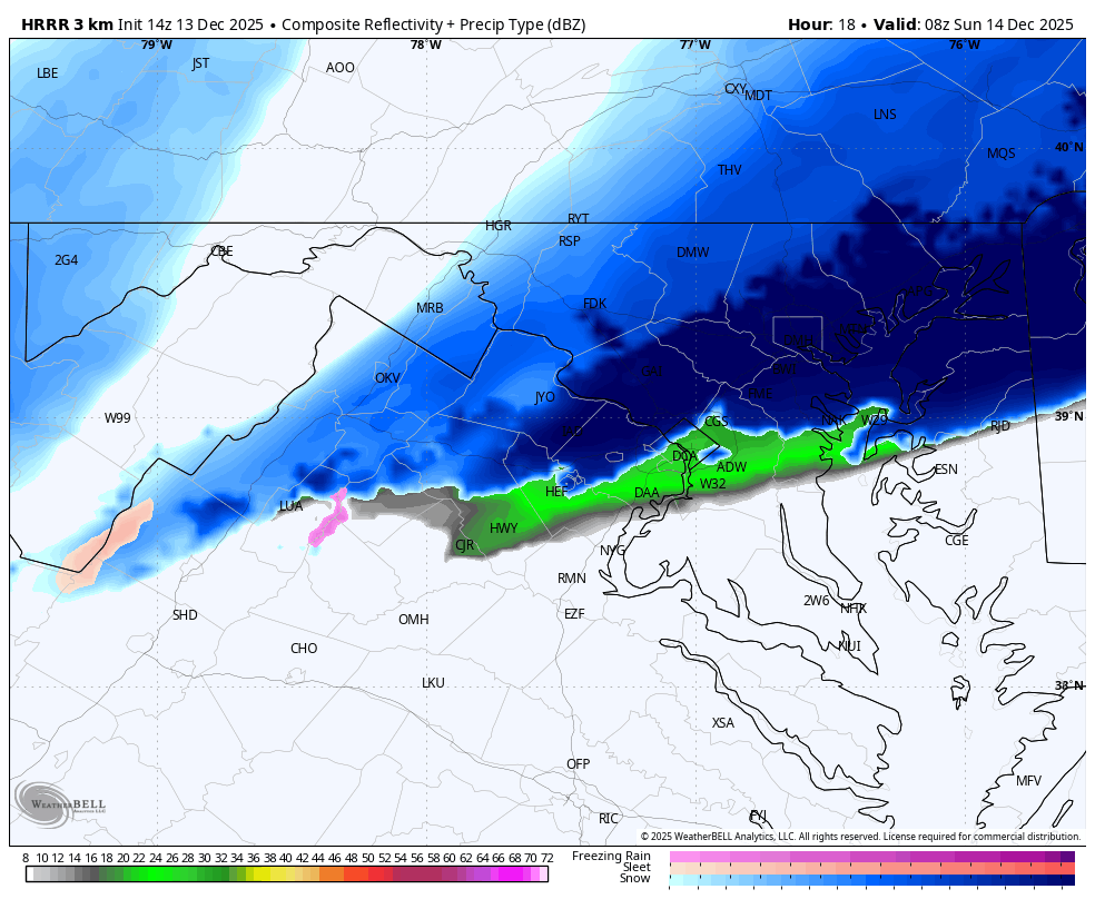
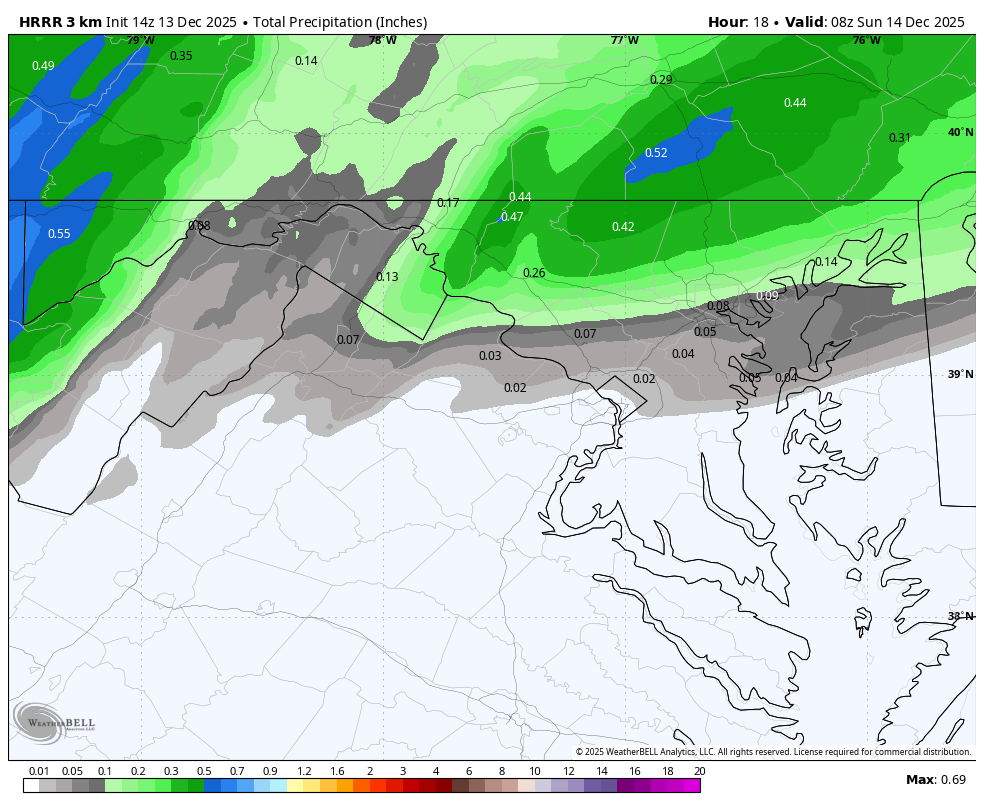
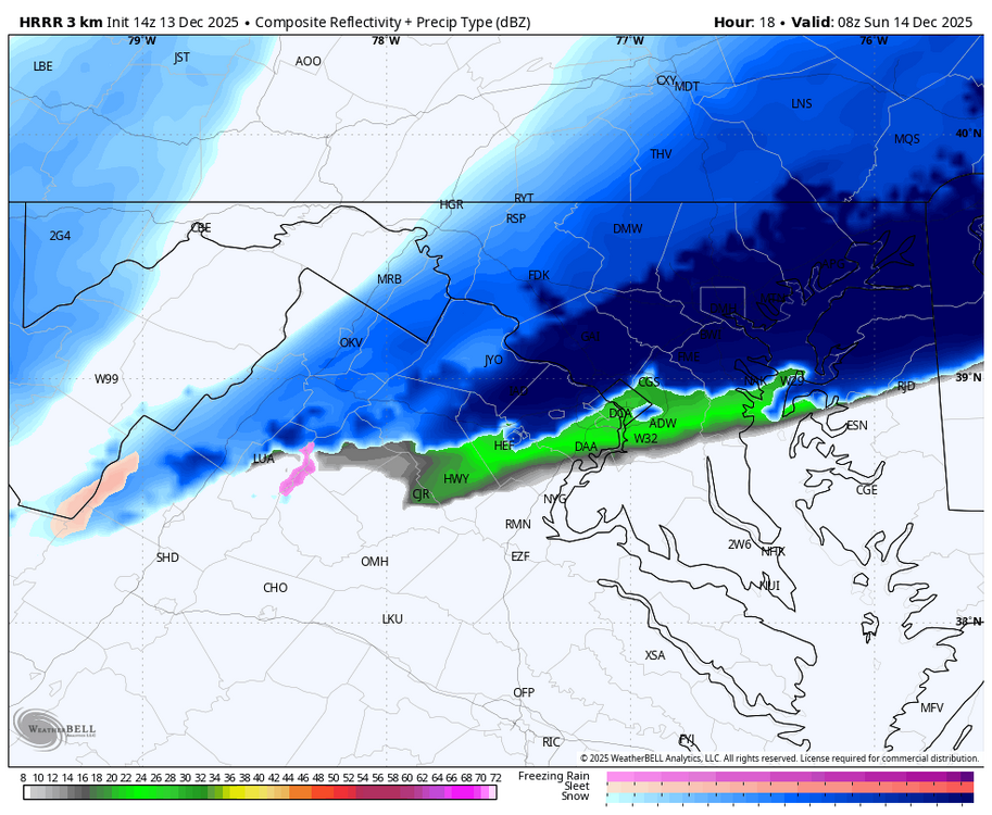
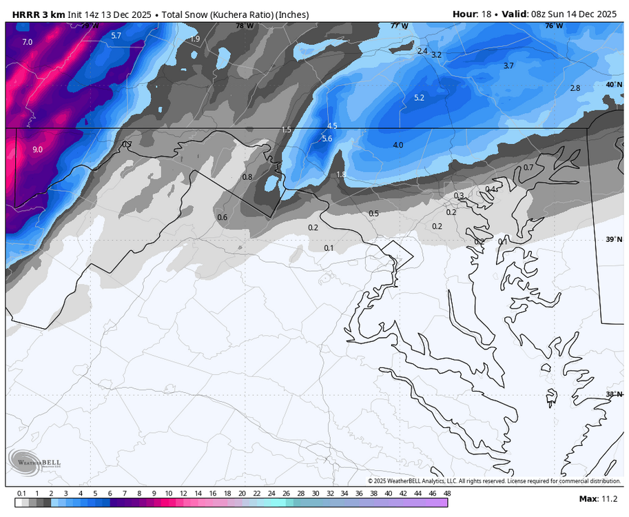
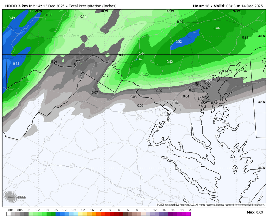
WB 14Z HRRR Hr. 18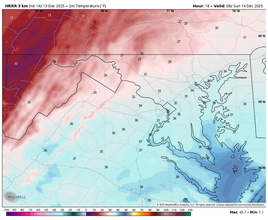
-
Pretty amazing to see Lindsey Vonn win World Cup Downhill at St Moritz. More than 7yrs since her last World Cup win and at the age of 41.
-
12/14: Sunday funday? Will the south win again?
winter_warlock replied to TSSN+'s topic in Mid Atlantic
Ukie is as reliable as the Mets are at keeping their players lol -

12/14: Sunday funday? Will the south win again?
Maestrobjwa replied to TSSN+'s topic in Mid Atlantic
This is so interesting how the weenie insanity manifested itself before phones and internet. But no matter the era...driving force was still the same, haha Whhyyy are we like this?? Lol We need to be studied! -

Central PA Winter 25/26 Discussion and Obs
Jns2183 replied to MAG5035's topic in Upstate New York/Pennsylvania
The cut of gradiant for this one is going to be brutal Sent from my SM-S731U using Tapatalk -
It still gives me about 1.5” imby, so if that’s the “worst” model, I’ll take. Happy to see balt corridor get the jack this time though
-
Oh man I'd shit my drawers if that happened!!!
-
at least dry air shouldn't be an issue with this one.
-
I have my 1-3" pants on.
-

Moderate snowfall 12/14/2025 WWA up for most of the area
jm1220 replied to WeatherGeek2025's topic in New York City Metro
I definitely see the chance for a northern weenie band somewhere, hopefully it doesn't park over the sound. That's where the mid level lift and fronto would be best and could sneak a 5-6" total. North of that unfortunately might be skunked somewhat with subsidence but we have to see how it evolves. Also liking how the snow seems to linger longer which might be based on the trough bending a little more and bringing more moisture north, so it might be more like a 12 hour event from maybe 3z to 15z around or east of the city. The sound might help enhance the snow as well over LI since we have a northerly flow with the storm-the northerly winds enhance lift through frictional convergence-the wind "piles up" over LI and forces air to rise. Should be a nice little event. Not huge by any means but on the upper end of what this kind of fast pattern allows. I could see a 6" total or two where the banding sits overhead and if the snow lingers for 12 hours or more. -
Risking more banter, I too am old enough to have OBSESSIVELY called 936-1212
-
 Yes true in all areas except near the Belvedere Castle/CPK weather station
 -

Central PA Winter 25/26 Discussion and Obs
pasnownut replied to MAG5035's topic in Upstate New York/Pennsylvania
as been of concern for the last few days, the coastal interaction is easters key to the snow globe toy chest. Prorgressive pattern keeps this thing moving, and still worries me that any delay, will quickly rob wester LSV folks, and even me as. Somethin to keep an eye on. While not a Miller B, similar attributes/characteristics in play IMO -
I also remember that my dad had a radio that could pick up NOAA Weather Radio stations, kinda dull way back in my youth but for its time it was pretty cool.
-

December 14th - Snow showers or Plowable snow?
ORH_wxman replied to Sey-Mour Snow's topic in New England
NAM has some really good snow growth on the south coast predawn and early morning tomorrow. So if they can get into some decent rates, they could fluff their way to low end warning. -
That thing is the Lucy of CAMs. Always the warmest, driest model it seems.
-
Yep, and no area code before it.