All Activity
- Past hour
-

The Monday wintry event potential (12/8/25)
landof2rivers replied to GaWx's topic in Southeastern States
I’ve been decorating Christmas trees for many years. Today was the only day I remember it snowing while I put the lights on the tree. Pandora played Christmas music and it was a day to remember! Probably banter, move if necessary. -
More of an up and in event.
-

2025-2026 Fall/Winter Mountain Thread
Buckethead replied to Buckethead's topic in Southeastern States
Not bad for a forecasted 1-2" event! Currently 25 with light snow in Wolf. Sent from my Pixel 10 Pro using Tapatalk -
31.3, I'm thinking 8 inches now looking at the radar.
-
The end of that 18z GFS run would make for some tough sledding on the 24th.
-

December 2025 Short/Medium Range Forecast Thread
Carvers Gap replied to John1122's topic in Tennessee Valley
Lets try that again, and this time NOT in centimeters. In my haste I clicked centimeters. Up to 30" of 10:1 snow. Most assuredly, if that wasn't Digital snow, that would be much more due to higher rates due to colder air. 40" Kuchera in W VA. -
Radar looks like its pivoting a bit. Might be the coastal cranking. Heavier here again. Could make a run at 4
-
Down to 5.9°F, We're going sub zero tonight.
-
That’s hilarious. A plant peeler of yore.
-

December 2025 regional war/obs/disco thread
moneypitmike replied to Torch Tiger's topic in New England
That would be great--I'm not seeing it that way. -
Wilton?
-
December 2025 Short/Medium Range Forecast Thread
Carvers Gap replied to John1122's topic in Tennessee Valley
It would make a lot of sense if the pattern was about to break for warm...for that blizzard to show in exactly that spot. The GFS has held to that since yesterday. I would encourage everyone to not get their hopes up. I actually don't like tracking Christmas systems since so many get their hopes up. But I really want to see the GFS hit this from day 16. Also, do remember that systems are often lost between d5-7. Let's get that out of the way now. LOL. -

Central PA Winter 25/26 Discussion and Obs
AccuChris replied to MAG5035's topic in Upstate New York/Pennsylvania
18z GFS long range eye candy says Merry Christmas to all, and to all a good night . -

December 2025 regional war/obs/disco thread
mahk_webstah replied to Torch Tiger's topic in New England
1040 and slightly west of yesterday’s 1035 -
Amazing the difference over 2-3 miles. We have the nice fluffy flakes though.
-
Still snowing here. I'll go with 3.5" for me. Might have hit 4 but the early compaction is what it is and I'm conservative with my measurements. Still snowing so maybe 4" is in the cards. This was such an awesome event. Snowed continuously from 7:30am past sunset. Cold north wind and dropping temps all day. Snow blowing off the eaves and trees. Dark grey sky when it did lighten up at times. True deep winter vibe and that doesn't come easy down this way. Very thankful for the good luck even though my friends north of me couldn't share this one. Tables will turn soon enough and I'll be on the outside looking in lol. I'm pretty satisfied for a while.
-
Now that’s fun: https://www.tropicaltidbits.com/analysis/models/?model=gfs®ion=us&pkg=uv250&runtime=2025120818&fh=354 This is Sunday: https://www.tropicaltidbits.com/analysis/models/?model=gfs®ion=us&pkg=uv250&runtime=2025120818&fh=138
-

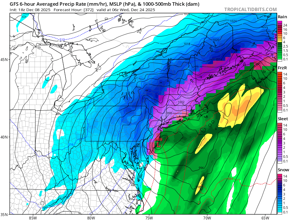
E PA/NJ/DE Winter 2025-26 Obs/Discussion
Ralph Wiggum replied to LVblizzard's topic in Philadelphia Region
OK, so let's skip over the next 5-6 days and go right to the monster Christmas Eve winter storm. Isn't 'perfect' but that is plenty close enough for me. Only need it to hold for about 60 more runs. 42 straight hours of wintry precip:
-

Richmond Metro/Hampton Roads Area Discussion
Rvarookie replied to RIC Airport's topic in Mid Atlantic
Looks like shut off edit: still got some dust flying around -
And the 18z GFS has a doozy leading up to Christmas for parts of NC. TW
-
Yes. It was 49/47 so it did not feel or smell anything like snow. We are rolling now though. Great start to the winter. Just took a quick peek outside and it is accumulating now. Coating on the cars and grass.
-
It's in la-la land sure, but yeah looks like a big (and quite cold) sleet/ice event mainly in the I-95 corridor around DC/Balt, with a snowstorm to the west and north! Mid-20s and ice? That would qualify as a @Bob Chill "glaciation" scenario! I say bring it!
-
yea, one heck of a storm. 30” in the jack zones, messy fun in the metros. But then again it’s the most normal winter GFS run, so
-
Yeah at some point this cold air will have to ease up. Very few winters have almost wall to wall cold. And in this climate, it’s nearly impossible. All the more reason to capitalize on the cold now and get some snow
-
Good points. But if there were a clearly identified long time model bias, adjusting for that would obviously make sense.