All Activity
- Past hour
-
https://science.nasa.gov/earth/arctic-winter-sea-ice-2026/#:~:text=End of dialog window.,Flight Center in Greenbelt%2C Maryland. For the second consecutive year, winter sea ice in the Arctic reached a level that matches the lowest peak observed since satellite monitoring began in 1979. On March 15, Arctic sea ice extent reached 5.52 million square miles (14.29 million square kilometers), very close to the 2025 peak of 5.53 million square miles (14.31 million square kilometers). Scientists with NASA and the National Snow and Ice Data Center (NSIDC) at the University of Colorado, Boulder, note that the two years are statistically tied. Along with the overall extent, researchers are also observing changes in ice thickness. “Based on what we’re seeing with NASA’s ICESat-2 satellite, much of the ice in the Arctic is thinner this year, especially in the Barents Sea northeast of Greenland.,” said Nathan Kurtz, chief of the Cryospheric Sciences Laboratory at NASA’s Goddard Space Flight Center in Greenbelt, Maryland. “The Sea of Okhotsk that borders northern Japan and Russia also had relatively low ice this year — a region that naturally experiences significant year-to-year variability.” Scientists with NASA and NSIDC found that this winter’s peak Arctic ice coverage continues the long-term trend observed over the past several decades. This year, peak ice cover was below the average levels between 1981 and 2010 by roughly half a million square miles (about 1.3 million square kilometers). Sea ice extent is defined as the total area of the ocean with at least 15% ice concentration. The area of the Arctic Ocean covered in ice expands in the cold of winter. Although much of the sea ice melts in warmer months, some ice remains throughout the year. Recently, less new ice has been forming. As a result, less multi-year ice has accumulated. “A low year or two don’t necessarily mean much by themselves,” said NSIDC ice scientist Walt Meier. But viewed within the long‑term downward trend since 1979, Meier added, they contribute to the overall picture of change in Arctic sea ice throughout the seasons.
-
The Summer of 2012 which followed was the 3rd warmest on record for the CONUS.
-
Agree I loved the cold this past winter but its not common. Give me alot of snow to rain or rain to snow events. The normal here.
-

Forecasting now vs. 30 years ago
FPizz replied to EWR757's topic in Weather Forecasting and Discussion
I haven't seen much improvement from the late 90s to now. More models, more resolution in those models and all it created was more chaos. With less models back 30 years ago, there was less of a guessing game to pick which model you thought was more accurate and more brain knowledge in each forecast. There are just as many busted forecasts now as there ever was. -
I have a forecast low of 28 on Tuesday night. Hoodie weather indeed
-
didn't they change the location though? philly runs very high all the time. rainshadow (Tony Gigi) who used to post here years ago and worked for mt holly for years still makes fun of their temps. I'll take a real met over the wannabe's in here any day.
-

2026-2027 El Nino
brooklynwx99 replied to Stormchaserchuck1's topic in Weather Forecasting and Discussion
hey, give me a loaded STJ and temps that aren't an abject torch and I'd like to see what happens now that we're in a paradigm of blockier winters. 2023-24 was cursed and I think people are scared about an outcome like that. I find it unlikely, there are much better analogs -

E PA/NJ/DE Spring 2026 Obs/Discussion
BBasile replied to PhiEaglesfan712's topic in Philadelphia Region
Picked up 0.95" of rain from the storms last night. Currently 44F. -
Those were the days: https://weather.com/retro/ https://x.com/weatherchannel/status/2039705220276535314?s=61 watched for hours on end. Sicko.
-
Those were the days: https://weather.com/retro/ https://x.com/weatherchannel/status/2039705220276535314?s=61 watched for hours on end. Sicko.
-

2026 Severe Wx - General Thread
SchaumburgStormer replied to largetornado's topic in Lakes/Ohio Valley
I would normally assume that this kind of morning rain would bone any severe chances, but these storms are moving and conditions should pop nicely once the warm front slams through. -
The more I look at this .. I wouldn't trust any warm pattern up our way through at least mid month. Not saying it will be like today - this is something else entirely. There are fewer days out of a year actually this repugnant. This is something uniquely egregious. We could get lucky ... but we can't seem to shake a negative anomaly in the deep troposphere circulation mode wobbling around the Canadian archipelago to D. straight and back. And as that is persistently there, the flow is naturally going to be episodically confluent across S-SE Canada. That's going to generate these high pressures that then suppress the ambient late season polar boundary S ...probably south of climatology at times, too. That PV has been plaguing that region for months, really... As we embark upon the warm season, it's not relenting... not yet anyway. I think until that does we relay on being lucky... Since I live here, and want it to be warm, unfortunately ... that means everyone else that wants it warm will end up UN lucky Probably we'll log another NASA month where relative to everywhere else around, we have a negative offset cooler region over SE Can/NE U.S. when the March numbers are settled.
-
Can’t wait for my 4pm warm sector on Friday that slams shut sunrise Saturday. Sat looks like definite toast now. NAM has screen doors slamming shut in CT midday.
-
Sooner or later they all catch up. Stay well, as always …
-

Forecasting now vs. 30 years ago
Devidbrain replied to EWR757's topic in Weather Forecasting and Discussion
Forecasting has certainly evolved, with high-resolution models, ensemble forecasting, and AI greatly improving accuracy. NWS meteorologists can still rely on experience and local knowledge to adjust guidance, especially in complex or rapidly changing situations. While modern forecasts are more data-driven, expert judgment remains crucial, so some subjectivity and forecaster “personality” still play a role. -
Rhea?
-

2026-2027 El Nino
mitchnick replied to Stormchaserchuck1's topic in Weather Forecasting and Discussion
I'd roll the dice with that. -
Oof

-
Drought worsened significantly across the entire region on the latest drought monitor.
- Today
-
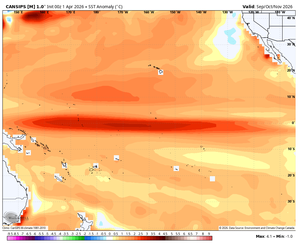
Cansips SON fwiw Modoki ~+2 in 3.4 (ONI), implying RONI ~~+1.5, with a peak ~+1.7 RONI in winter:

-
I still want to ski a couple more times... Not sure it will happen on the weekend of April 11/12, but I will try
-
2026-2027 El Nino
mitchnick replied to Stormchaserchuck1's topic in Weather Forecasting and Discussion
Not that anyone should care what I think, I'm stillnot seeing west anomalies prevailing over forecasts periods thru June. Gfs and Cfs are now both showing (I understand the relationship between the models) and easterly anomaly over the next week that has intensified over the past few days as reflected on the 2 attachments. That should knock 3.4 temps down a bit again. Again, I'm not saying a mod or strong Niño isn't possible, but more that the Niña continues to put up a decent fight..thumb.gif.599de0dd56cd4543ab238b95cef224c0.gif)
.thumb.png.efeba6d8451a24a5d1133be215435579.png)
-
Stuck in the nasty muck. What a difference a day makes today from yesterday and today to tomorrow. Hope we can get more sun tomorrow
-
Normally I’d wish that were happening here too…but not now. I’d rather have 65-70 with clouds and sun today. 41 with drizzle…
-

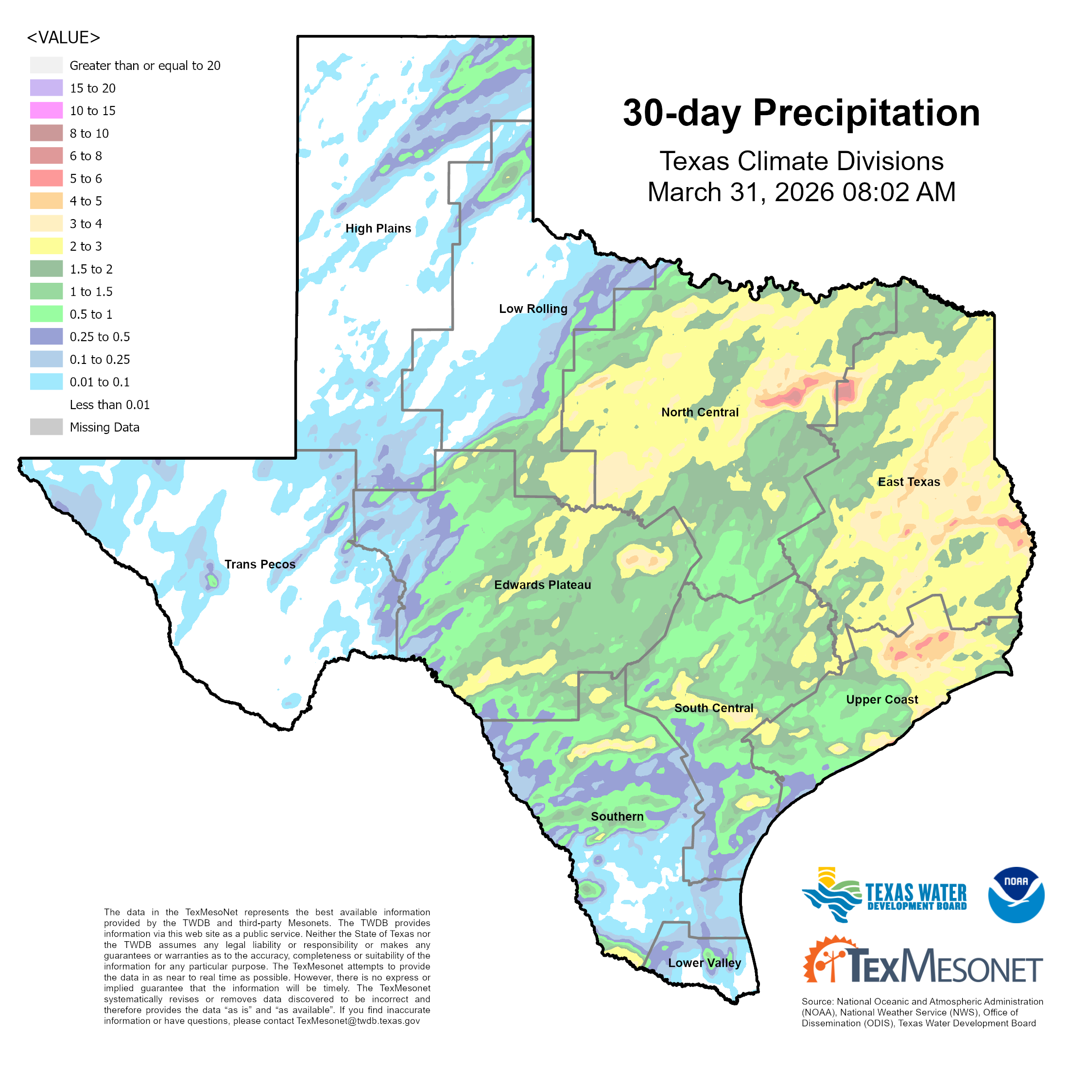
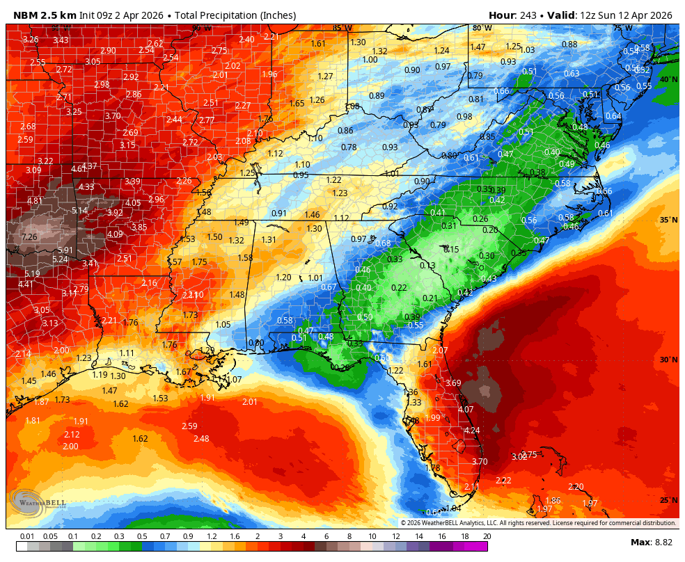
Texas 2026 Discussion/Observations
Stx_Thunder replied to Stx_Thunder's topic in Central/Western States
Not bad for March: Especially considering last year's March (2025) was sig drier with all the wildfires that also occurred. If we keep this up in April & May (likely a good bet now with ENSO transition back to EN territory finally underway), much of the ongoing statewide drought conditions should be taken care of at least till later summer. Things are already looking pretty wet (for the time of year) this Easter weekend with substantial MCS activity likely, and then again into mid-April.


.gif.c1451bb7392c14b7a8396f3cb56c24c1.gif)
.png.df8c720da5ae033468bc0467962d9768.png)