All Activity
- Past hour
-
AIGFS is a little colder on the surface then previous runs. Not super ptype confident but think it might be snow -> ice for most north of 66
-
GFS manages to squeak out a little Christmas Day snow TV for some folks in northern Maryland. Torchmas
-
Until tomorrow
-
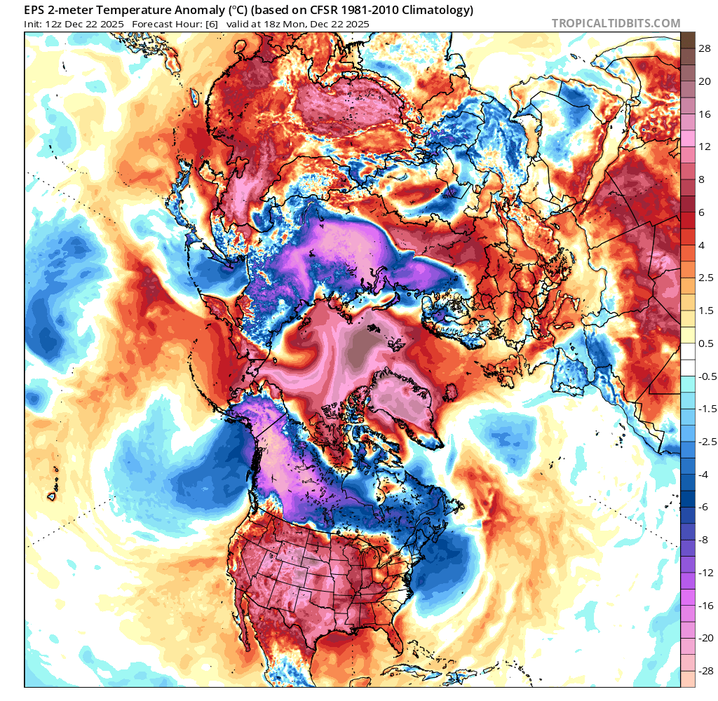
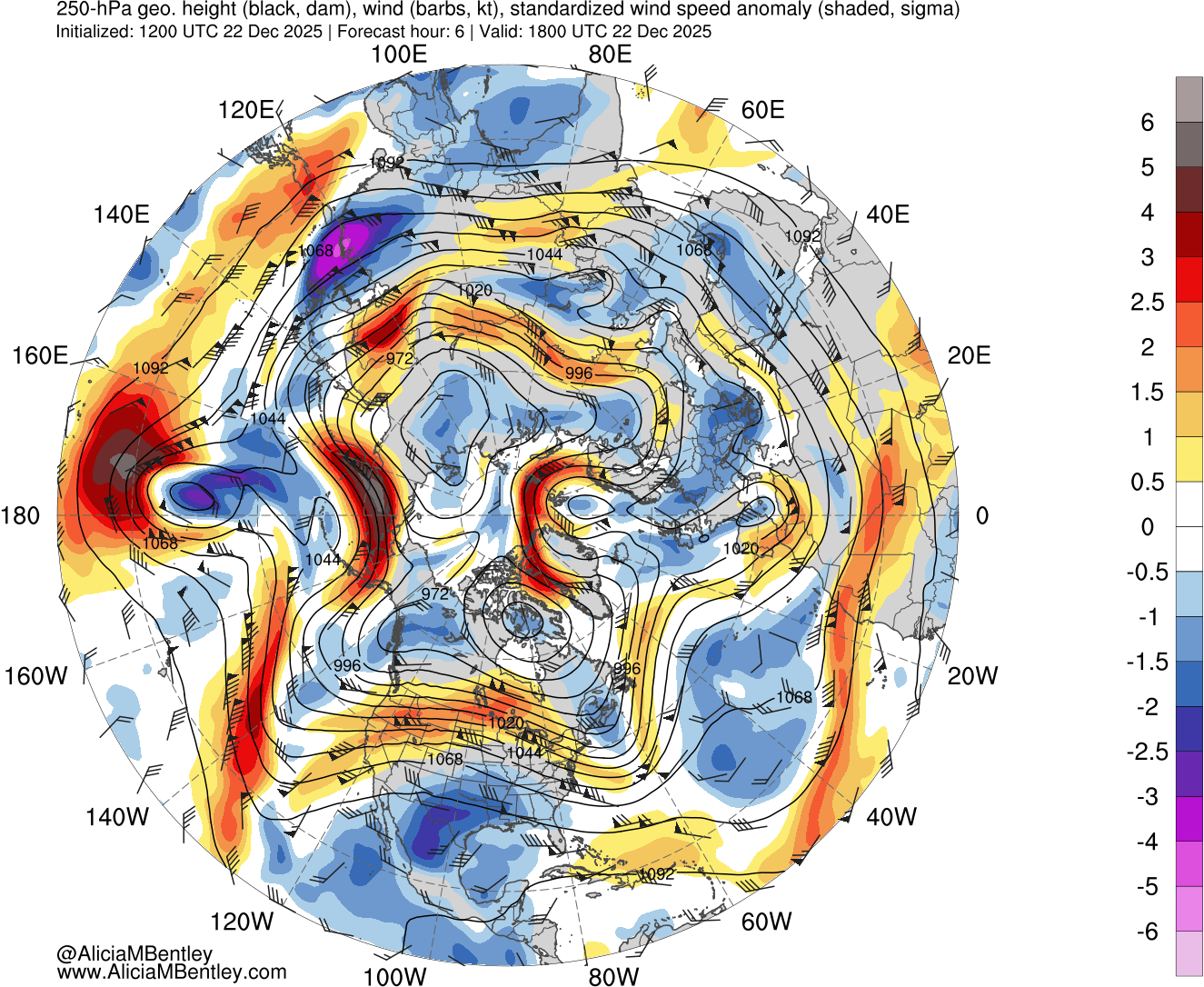
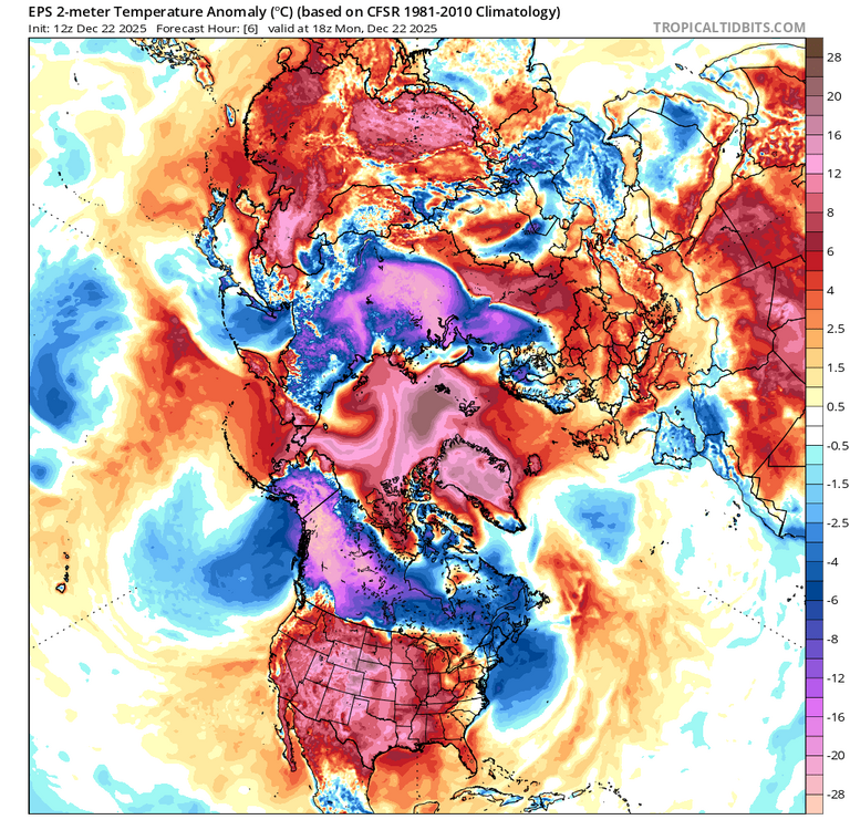
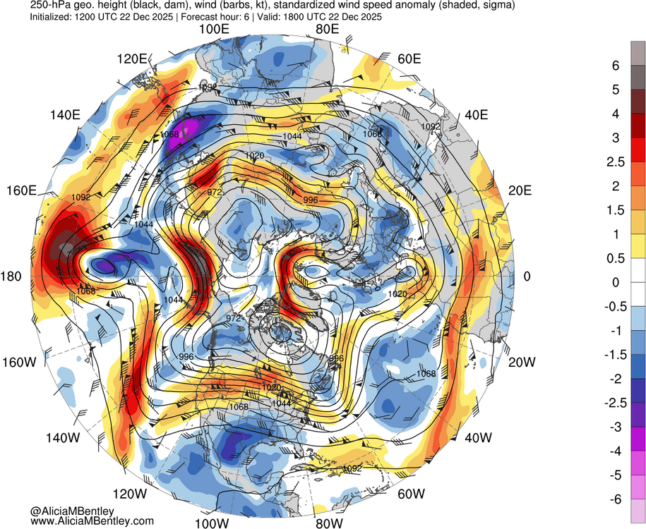
Extreme temperature gradients in Asia and North America. Multiple 4 to 5 sd Jet streaks along the thermal gradients. Overall the Northern Hemisphere is very warm for this time of year due to the warmth covering more real estate. So it will be hard to trust individual model storm details beyond 72-96 hrs. Since a tiny shift in the gradient between the strong 500 mb mid and high latitude blocking ridges can cause a big swing in local sensible weather. So we can say it’s looking like a very active pattern with the details to be worked out in the short term.
-
This is what we need at a minimum. A more established block /more confluence/ stronger HP to the west of the 50-50 low would be better.
-
I actually didn't say I preferred it, you assumed that..it was noteworthy because the models suddenly chopped 20° off our highs overnight. But of course, your assumption was correct. The untimely melting of the snow makes for a bare Christmas, but the ground is frozen and lakes covered in ice and January and February are big winter rec months in Michigan...so why on earth would I want 60 over 40?
-

White Christmas Miracle? December 23-24th
ORH_wxman replied to Baroclinic Zone's topic in New England
Yeah…high outlier comes back to earth. Still think 1-3” away from immediate shore is the good play. -

December 2025 Short/Medium Range Forecast Thread
Met1985 replied to John1122's topic in Tennessee Valley
That's freaking awesome. -

White Christmas Miracle? December 23-24th
tamarack replied to Baroclinic Zone's topic in New England
Between the increasing snow forecasts for our area and the kids running thru norovirus (some at peak, some all better), the trip will be on Wednesday. Dealing with Christmas Eve traffic seemed the better choice. GYX afternoon added an inch to the above 3-5. Hoping for nice dendrites and 12-15:1 ratios rather than crummy flakes and 8-9:1. -
Ideally yes. Lets hope. I have my doubts.
-

White Christmas Miracle? December 23-24th
SouthCoastMA replied to Baroclinic Zone's topic in New England
nice rug pull at 18z. HRGEM is paltry -
A weak system will bring some light snow possibly mixing with or ending as some light rain or drizzle in some areas tomorrow. New York City will likely see a coating to 1". A 1"-3" snowfall is possible in the northern and western suburbs where it will be somewhat colder. The temperature will likely remain above freezing throughout the day on Tuesday in New York City. In New York City, only 25.6% of storms have seen measurable snowfall with a daily low of 33° or above with just 9.2% seeing 1" or more snowfall. Almost three-quarters (74.4%) of such events have seen only a trace of snowfall. Another system could bring precipitation on Friday into Saturday. This system could have more moisture to work with than tomorrow's. No exceptionally cold or warm weather appears likely for the first week of astronomical winter. The closing days of December will likely be colder than normal. December 2025 will likely finish with a maximum monthly temperature below 60° in New York City. The last time that happened was in 2019 when the monthly high was 58°. If 2025 has a monthly high below 60°, that would be only the fifth such occurrence since 2000 (2003, 2004, 2005, and 2019 are the cases since 2000). The ENSO Region 1+2 anomaly was -0.6°C and the Region 3.4 anomaly was -0.8°C for the week centered around December 17. For the past six weeks, the ENSO Region 1+2 anomaly has averaged -0.40°C and the ENSO Region 3.4 anomaly has averaged -0.68°C. La Niña conditions will likely continue through at least mid-winter. The SOI was +10.59 today. The preliminary Arctic Oscillation (AO) was +1.620 today. The PNA was -1.766. That's the lowest winter value since December 24, 2021 when the PNA was -2.084. Based on sensitivity analysis applied to the latest guidance, there is an implied near 100% probability that New York City will have a cooler than normal December (1991-2020 normal). December will likely finish with a mean temperature near 34.3° (4.8° below normal). Supplemental Information: The projected mean would be 3.1° below the 1981-2010 normal monthly value.
-

White Christmas Miracle? December 23-24th
Sey-Mour Snow replied to Baroclinic Zone's topic in New England
GFS cut back a good bit at 18z as expected.. has the “relative min “ from Waterbury to ORH -

December 2025 regional war/obs/disco thread
DavisStraight replied to Torch Tiger's topic in New England
You do that by remote? I didn't see you there. -
No. Below are the PNA values: 2004 1 27 0.127 2004 1 28 0.228
-

December 2025 regional war/obs/disco thread
TauntonBlizzard2013 replied to Torch Tiger's topic in New England
Someone is going to get a good smack from this Friday Saturday deal, unfortunately, it’s looking like that’s going to be south of New England. Jersey gets clobbered on some of these runs -
IMO it already has lol
-
Beautiful day to take down a tree ( aren't they all?). Bluebird skies...
-
I think you put it very eloquently in one of your past posts—it's called meteorology, not modelogy. Great call there.
-

December 2025 regional war/obs/disco thread
Cyclone-68 replied to Torch Tiger's topic in New England
I stand corrected…Good catch -
December 2025 regional war/obs/disco thread
DavisStraight replied to Torch Tiger's topic in New England
Joe Rudi and Rollie Fingers, Sparky was history, we weren't getting him back. -

Central PA Winter 25/26 Discussion and Obs
mahantango#1 replied to MAG5035's topic in Upstate New York/Pennsylvania
You mean you were going over to strong arm them. You know you can't reason with them dudes. -
As I mentioned in your excellent post yesterday, the models are catching up to what the analogs say Must happen
-
White Christmas Miracle? December 23-24th
Sey-Mour Snow replied to Baroclinic Zone's topic in New England
RRFS too -
December 2025 regional war/obs/disco thread
DavisStraight replied to Torch Tiger's topic in New England
And we traded him for Danny Cater, dumbasses