All Activity
- Past hour
-
We shall see!

-
Don, where did you get your numbers for the 18z HRRR and NAM output? They don't match pivotal, so I assume you derived them somehow. But using what method? I don't think you responded to this question from earlier. To my knowledge, bufkit does not output snow/ice accumulations. Your tables also reinforce the false belief that weather models generate forecasted snowfall as output.
-
Yep, I get so tired of people saying, oh, the cold is a week away.The cold is a week away, and then it gets pushed back.And pushed back, and then when we actually do get into the cold..Nowhere near is.It has historic as the temperature guidance suggested instead of like being thirty degrees below.Average.It's like ten
-

Ice Ice Baby December 28-29 Storm Discussion
powderfreak replied to Baroclinic Zone's topic in New England
Latent heat release is real. SLK with a quick 0.07” at temps in the 20s. Gotta be slick out there. The ice maps are just QPF at temps 32F or lower… but a tenth of an inch as ZR gets slippery in a hurry on roads, driveways, parking lots, etc. -

Ice Ice Baby December 28-29 Storm Discussion
tavwtby replied to Baroclinic Zone's topic in New England
every year they're out there throwing sparks at nothing, but the other night didn't see a plow until well after midnight, they're out now slipping and sliding up the hill trying to treat it, waste time and resources early and if we have a rough winter cry about budget in February they're out of sand and salt etc...btw, still 30 and pretty steady ZR here now, my station needs new batteries so closest one will have to due -

Ice Ice Baby December 28-29 Storm Discussion
WxWatcher007 replied to Baroclinic Zone's topic in New England
30.3° -

Ice Ice Baby December 28-29 Storm Discussion
Chrisrotary12 replied to Baroclinic Zone's topic in New England
GYX really leaning into the ice huh? -
THIS IS TRUTH
-

E PA/NJ/DE Winter 2025-26 Obs/Discussion
RedSky replied to LVblizzard's topic in Philadelphia Region
31F -
"Letter of the law" how so? All the data I've pored over supports the idea that the NAM performed best with QPF and ptype from about 3 days out until Friday afternoon. The ECM was probably second best with a late adjustment northeastward. The NAM was consistently 0.2 - 0.5" liquid across the NYC metro with a frozen ptype over its last few runs before the event. Despite "generous" final tallies for EWR and NYC, that's how it played out. It was best in the LHV, ENY, CT, and SNE. The ECM was too far southwest across the board. I'm not even sure how this is contentious. I feel like Don is/was biased against the NAM leading to a non-scientific and distorted assessment.
-

Ice Ice Baby December 28-29 Storm Discussion
CT Valley Snowman replied to Baroclinic Zone's topic in New England
Up to 31 -
December 2025 regional war/obs/disco thread
powderfreak replied to Torch Tiger's topic in New England
A mesoscale winter. Lake effect, upslope, the moist cold air advection spots. And a few random synoptic events. Suppressed at times. -
We got way too many models to keep up with now imo
-

January 2026 Medium/Long Range Discussion
RevWarReenactor replied to snowfan's topic in Mid Atlantic
GFs is warm wet cold dry. Great patterns have been 2 weeks away for the last 10 years. -
Absolutely no need for those conditions... Terrible DPW management!
-
Ice Ice Baby December 28-29 Storm Discussion
WxWatcher007 replied to Baroclinic Zone's topic in New England
27.6/25 on a very light NNE wind. Probably above freezing by midnight. -
Yeah. He does a good job. I don't know what's going on with the US Model's. Maybe they were recently "upgraded". If so, maybe DEI Hires did them.
-
Nope
-

Pittsburgh/Western PA WINTER ‘25/‘26
colonel717 replied to Burghblizz's topic in Upstate New York/Pennsylvania
-

Ice Ice Baby December 28-29 Storm Discussion
tunafish replied to Baroclinic Zone's topic in New England
Bottomed out at 23° here around 7, upta 25° now. -
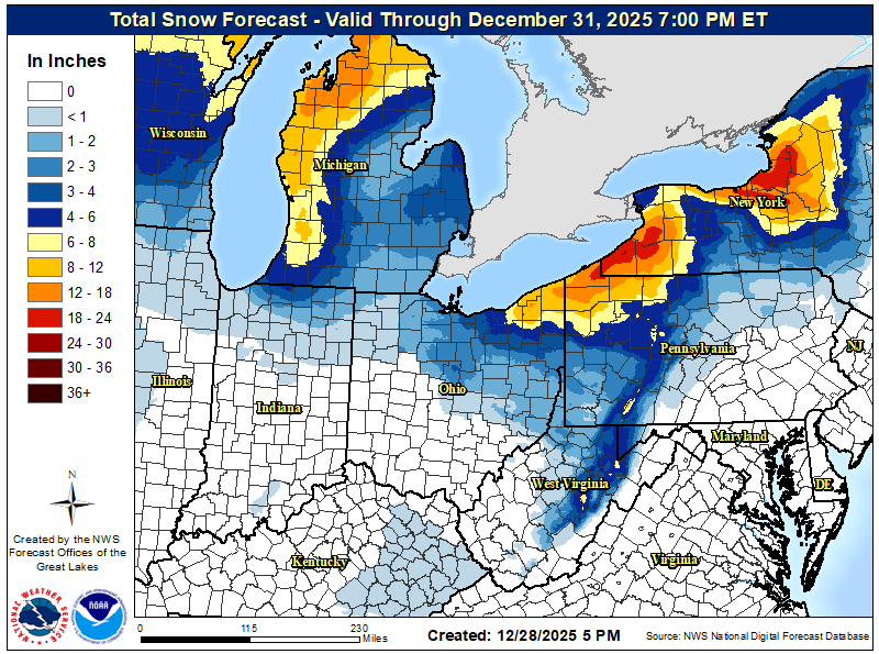
Looks like good snow showers and squalls over Appalachian mountains and inland regions of PA and New England. Those rarely ever make it to the coast. Looks cold enough for accumulation though if anything does fall.
-

-

Some Historic Snowstorm/Nor'easter Obs/Statements
vortex95 replied to vortex95's topic in New England
Here's a decoded hourly obs string from the above storm for KFMH. Dendrite nirvana!
-

Ice Ice Baby December 28-29 Storm Discussion
Damage In Tolland replied to Baroclinic Zone's topic in New England
Models trended lower today for highs tomorrow