All Activity
- Past hour
-
 July DCA _ NYC _ BOS _ ORD _ ATL _ IAH _ DEN _ PHX _ SEA 2.1 2.4 1.9 2.6 2.3 2.0 2.3 1.3 1.9
 -
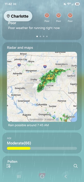
Glad for you all that are getting the rain! Much needed. We missed it by about 20 miles. Hopefully we get some tomorrow.
-
Just checking what the 12z ICON days for fun for Wednesday to Friday at DCA... oh. 103/106/106... HI values 110-115
-

Occasional Thoughts on Climate Change
Silver Meteor replied to donsutherland1's topic in Climate Change
The deeper you look the more you find narrative-driven quackery. https://grokipedia.com/page/World_Weather_Attribution -
0.36 here. A slight chance of showers tomorrow morning. Looks like the heat comes back next week. Area Forecast Discussion National Weather Service New York NY 1034 AM EDT Fri Jun 26 2026 DISCUSSION... .KEY MESSAGE 1... Area in warm sector with southerly flow. The southerly flow increases this afternoon becoming gusty along parts of the coast. The rain showers with left front quad dynamics will be less expansive and decrease in probability later this morning when the dynamics are less favorable. Showers with possible embedded thunderstorms into early this morning will be capable of producing locally heavy rain. There will be building instability but drier air and a lack of vertical moisture. So, the cold front is not expected to result in additional shower and thunderstorm activity as it approaches this afternoon and moves across this evening into overnight. The chances for showers increase late tonight into Saturday as a wave of low pressure develops along the cold front south of the region. There may be enough elevated instability for a possible thunderstorm but probabilities for these are slight chance. Max temperatures in the 80s today for most locations and more in the 70s to near 80 Saturday with that greater chance of showers. .KEY MESSAGE 2... Building heat potential late weekend into next week. Mainly dry but a few disturbances may bring about some periodic showers and thunderstorms next week. High pressure moves in by Sunday and into Monday. This high pressure area settles south of the region and becomes based in Western Atlantic thereafter. Mainly dry conditions expected Saturday night and through the rest of the weekend as well as through Monday. Chances for any showers and thunderstorms will be tied more to any occasional disturbances, weak waves of low pressure or embedded shortwaves in the mid level flow aloft Tuesday onward next week. There are relatively higher chances as the week progresses as there will be more daytime instability to help make the air more buoyant. The forecast used a blend of forecast guidance for late weekend into next week for temperatures. Forecast high temperatures well into the 80s for Monday will get more into the 90s as the week progresses with more of the region getting into the 90s range. With the synoptic setup, airmass will become humid as well, with potential max heat indices in the mid 90s to near 100 range for mid to late next week.
-
Let it be known that literally no one called for this..... but we will for sure take it. What a beautiful surprise this morning.
-

2026-2027 Super El Nino
40/70 Benchmark replied to Stormchaserchuck1's topic in Weather Forecasting and Discussion
Are you certain that you didn't receive 17.574" last season? Lots of slat-stickers down there in the mid atl... -

Junorch obs and discussion 2026
Damage In Tolland replied to Damage In Tolland's topic in New England
Who will hit 140?!! -
Thanks for stealing my lines, imitation is the sincerest form of flattery.
-
Happy Birthday @stormtracker, are you turning 69 or 70 today?
-
Hopefully that big heat materializes.
-
Have you tried requesting the desktop site on your phone? I can't remember if it will give you the new page on your phone...it works on the ipad, but sometimes the phone is different. Both of these links may revert to the legacy page for you. https://weather.cod.edu/forecast/legacy/ https://weather.cod.edu/forecast/ Edit...requesting desktop site worked for me on the iphone
-
Do you have the link for the new page? I can’t even find that.
-
95-100F for all!
-
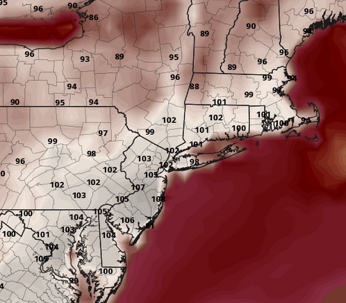
wow... this ICON model has just been masturbating this heat idea, unrelenting. This rendition off 00z is truly historic next Thursday in the M/A ... No picnic in SNE either.
-
Joe Namath is sober so far
-
Finally there is no lag! Hopefully it’s done! Anyone else seeing a big improvement? Maybe wow fixed it? @Maggie Valley Steve
-

Winter 2026-2027 Seasonal Outlook
GaWx replied to WinstonSalemArlington's topic in Southeastern States
A lot of 45 degree rains would themselves be great news to relieve the drought. A lot of rains at any temp! Relieving the drought would make it a good winter whether or not any there are any widespread SE winter storms. If one happens to be a winter storm, which wouldn’t be hard to occur, that would be icing on the cake. -
My goal is to never have to use our damage assessment or debris management plan, so no.
-
So what I'm hearing when you say that is that you're asking for a heat dome derecho.
-

2026-2027 Super El Nino
FPizz replied to Stormchaserchuck1's topic in Weather Forecasting and Discussion
Understand. My kids are 16 months apart, but it was a son then identical girls, so went from 0 to 3 kids fast. Now they are all in college... -
ahh yes...yeah the new site is much better. Wish it was available mobile (unless it is now)
- Today
-
no issues today so far fwiw on American. from my end
-
PC defaults to the new site which I said seems faster to respond/load.
-
Do you use it on pc or mobile? cod is definitely not user friendly mobile


.thumb.gif.f92b16c631a1d15d405ed77b33f0710d.gif)


