All Activity
- Past hour
-
15 years ago today we were tracking a monster storm. Today we are tracking its little brother for the same date lol
-

White Christmas Miracle? December 23-24th
TauntonBlizzard2013 replied to Baroclinic Zone's topic in New England
0.0 -
You may need to import water from the Chesapeake.
-

Boxing Night Snow/Sleet/Ice Dec 26-27 Storm Thread/Obs.
Albedoman replied to Mikeymac5306's topic in Philadelphia Region
throw this map out. No way does this storm produce the mixed lines like this. None of these boundary lines follows physical geography. What a waste. Historical weather patterns in my lifetime point to the evolution of the storm producing pingers in the last two hours of the storm event, then to a quick shot of freezing rain and then the final cake frosting of freezing drizzle in the LV with a normal thump of 6-8 inches of snow. That is a safe bet right now. All I can say is it will be one hell of back breaking shoveling event. Snow blower special indeed., Under a winter storm watch now too -
Honeybees show up at the bird feeders often during mild periods in winter. Must be a hint of pollen that draws them in. Helps that the neighbor has 6 hive boxes
-
Radar drying up, Took the last measurement and will end with 18" final.
-

December 2025 Short/Medium Range Forecast Thread
John1122 replied to John1122's topic in Tennessee Valley
We will see if it holds, but the Aleutian ridge is basically eliminated by the end of the Euro run and it looks like a +PNA is building. If that happens, January 10th and beyond could be plenty of Pacific driven good times. Traditionally when it collapses extreme winter periods of 2 to 3 weeks can happen. -
2020. 10.5" in December (December 16-17 snowstorm) and 38.6" seasonal snowfall.
-

White Christmas Miracle? December 23-24th
SouthCoastMA replied to Baroclinic Zone's topic in New England
Congrats to E Plymouth County and outer Cape. nada accumulation here, in between best bands -
GFS will always underdo mid-level warmth though in that scenario the flow aloft at the warmest level is like from 280, not as bad as it being from 230 but probably still verbatim underdone a bit. Its why I said before you'll see ratios near 10:1 eventually, even if its 25F at the surface if you're -1C at 750 or 800
-

Occasional Thoughts on Climate Change
TheClimateChanger replied to donsutherland1's topic in Climate Change
Clearly, the urban heat island effect at work in a town of 31,000 spawled across 3,250 square miles. -
96th street.
-
correct..
-
Occasional Thoughts on Climate Change
TheClimateChanger replied to donsutherland1's topic in Climate Change
To be honest, not seeing much evidence of increasing cold extremes in the Juneau data. -

26th-27th event, coming at us like a wounded duck.
weatherwiz replied to Go Kart Mozart's topic in New England
Initial thoughts: Greatest uncertainty is the farther northeast into the state you go. The greatest warm air advection is going to occur well to our southwest, from PA into NJ and likely clipping southwest Fairfield County. Where this occurs is critical because this is where the heaviest banding of snow will occur along with the heaviest rates and highest ratios. I think there is room for some higher totals in southwest CT (possibly in the 6-8" range) but there are questions about drier air advecting in aloft and drying out the DGZ. This could result in a solid 2-3 hour window of moderate-to-heavy snow with snow quickly decreasing in intensity and snow growth become poor. This would also occur as the WAA diminishes. It is also very possible the mesos are throwing us caution flags which need to be considered as many of the mesos essentially have one heavy band, with little outside of this band. That would fit the mold of this setup well as much of the forcing is tied into the strong WAA. Might have time to update this tomorrow. Depends on what I have going on for Christmas after work.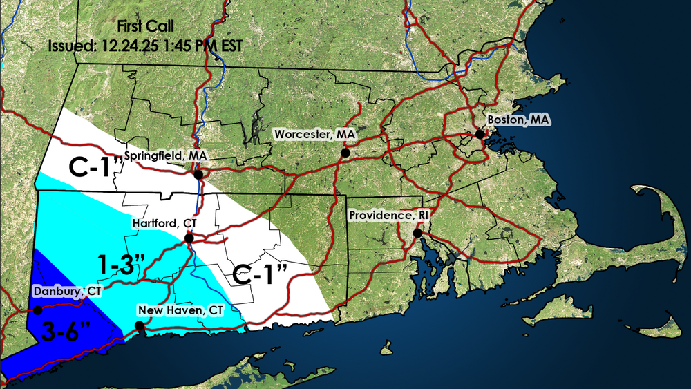
-
Another nothing burger out here. We are going to be in very dire straights out here this summer unless something drastically changes.
-
2020 I think
-

White Christmas Miracle? December 23-24th
Baroclinic Zone replied to Baroclinic Zone's topic in New England
Nope -
craig should the permanent weather forecaster on channel 2 and not lonnie quinn
-

26th-27th event, coming at us like a wounded duck.
tavwtby replied to Go Kart Mozart's topic in New England
can we please get a bump NE, I'd love to end December with at least close to double digit snowfall... -
If this all plays out as expected? When was the last time Central Park recorded 10" of snow in December? And how did that winters final totals end up?
-
Occasional Thoughts on Climate Change
TheClimateChanger replied to donsutherland1's topic in Climate Change
Odd, why were -10s and -20s relatively common from the 1940s to 1970s in Juneau? But only twice since (1995 & 2025)? Very weird. Regardless, a quick search shows downtown Juneau was as low as -17F in 1998, so I don't know why the airport was so much warmer. By contrast, Salt Lake City has been above its prior monthly record high minimum temperature (since 1874!) for two consecutive days, and likely a third unless it drops to 52 or lower by midnight. So I don't think those two events are actually comparable from a historical climate standpoint. -

Winter 2025-26 Medium/Long Range Discussion
sbnwx85 replied to michsnowfreak's topic in Lakes/Ohio Valley
Looks like a swing and a miss unless you only look at the Canadian. 12z runs were brutal overall. -
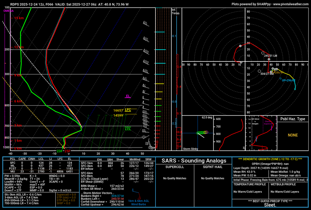
Here's the RGEM, shows a very shallow level above freezing but it's only towards the tail end of the event and if rates are still decent enough maybe we can overcome it. It would still yield a beautiful front end thump regardless.
-

Central PA Winter 25/26 Discussion and Obs
Summit Snow replied to MAG5035's topic in Upstate New York/Pennsylvania
URGENT - WINTER WEATHER MESSAGE National Weather Service Binghamton NY 119 PM EST Wed Dec 24 2025 NYZ025-044-045-055>057-062-PAZ039-040-044-048-072-250630- /O.NEW.KBGM.WS.A.0013.251226T1800Z-251227T1700Z/ Tompkins-Cortland-Chenango-Tioga-Broome-Delaware-Sullivan- Susquehanna-Northern Wayne-Lackawanna-Pike-Southern Wayne- Including the cities of Owego, Honesdale, Norwich, Waverly, Hallstead, Equinunk, Delhi, Milford, Binghamton, Damascus, Cortland, Ithaca, Montrose, Scranton, Walton, and Monticello 119 PM EST Wed Dec 24 2025 ...WINTER STORM WATCH IN EFFECT FROM FRIDAY AFTERNOON THROUGH SATURDAY MORNING... * WHAT...Heavy snow possible. Total snow accumulations between 5 and 10 inches possible. * WHERE...In New York, Broome, Chenango, Cortland, Delaware, Sullivan, Tioga, and Tompkins Counties. In Pennsylvania, Lackawanna, Northern Wayne, Pike, Southern Wayne, and Susquehanna Counties. * WHEN...From Friday afternoon through Saturday morning. * IMPACTS...Travel could be very difficult. The hazardous conditions could impact the Friday evening commute. PRECAUTIONARY/PREPAREDNESS ACTIONS... Monitor the latest forecasts for updates on this situation.


